
King's Cross railway station, also known as London King's Cross, is a passenger railway terminus in the London Borough of Camden, on the edge of Central London. It is in the London station group, one of the busiest stations in the United Kingdom and the southern terminus of the East Coast Main Line to Yorkshire and the Humber, North East England and Scotland. Adjacent to King's Cross station is St Pancras International, the London terminus for Eurostar services to continental Europe. Beneath both main line stations is King's Cross St Pancras tube station on the London Underground; combined, they form one of the country's largest and busiest transport hubs.
St Pancras is a district in central London. It was originally a medieval ancient parish and subsequently became a metropolitan borough. The metropolitan borough then merged with neighbouring boroughs and the area it covered now forms around half of the modern London Borough of Camden. The area of the parish and borough includes the sub-districts of Camden Town, Kentish Town, Gospel Oak, Somers Town, King's Cross, Chalk Farm, Dartmouth Park, the core area of Fitzrovia and a part of Highgate.

King's Cross is a district on either side of Euston Road, in north London, England, 1.5 miles (2.4 km) north of Charing Cross. It is bordered by Barnsbury to the north, Clerkenwell and Islington to the east, Holborn to the south and Somers Town to the west. It is served by two major rail termini, St Pancras and King's Cross. King's Cross station is the terminus of one of the major rail routes between London and the North.

St Pancras railway station, officially known since 2007 as London St Pancras International, is a major central London railway terminus on Euston Road in the London Borough of Camden. It is the terminus for Eurostar services from Belgium, France and the Netherlands to London. It provides East Midlands Railway services to Leicester, Corby, Derby, Sheffield and Nottingham on the Midland Main Line, Southeastern high-speed trains to Kent via Ebbsfleet International and Ashford International, and Thameslink cross-London services to Bedford, Cambridge, Peterborough, Brighton, Horsham and Gatwick Airport. It stands between the British Library, the Regent's Canal and London King's Cross railway station, with which it shares a London Underground station, King's Cross St Pancras.

St Pancras was a civil parish and metropolitan borough in London, England. It was an ancient parish in the county of Middlesex, governed by an administrative vestry. The parish was included in the area of responsibility of the Metropolitan Board of Works in 1855 and became part of the County of London in 1889. The parish of St Pancras became a metropolitan borough in 1900, following the London Government Act 1899, with the parish vestry replaced by a borough council. In 1965 the borough was abolished and its former area became part of the London Borough of Camden in Greater London.

Holborn and St Pancras is a parliamentary constituency in Greater London that was created in 1983. It has been represented in the House of Commons of the Parliament of the United Kingdom since 2015 by Sir Keir Starmer, the current Leader of the Labour Party and Leader of the Opposition.

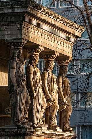
St Pancras Church is a Greek Revival church in St Pancras, London, built in 1819–22 to the designs of William and Henry William Inwood. The church is one of the most important 19th-century churches in England and is a Grade I listed building.

All Saints Cathedral, Camden Street, London, originally All Saints Church, Camden Town, St Pancras, Middlesex, is a church in the Camden Town area of London, England. It was built for the Church of England, but it is now a Greek Orthodox church known as the Greek Orthodox Cathedral Church of All Saints. It stands where Camden Street and Pratt Street meet.
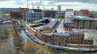
King's Cross Central (KXC) is a mixed-use development in the north-east of central London. The site is owned and controlled by the King's Cross Central Limited Partnership. It consists of approximately 67 acres (27 ha) of former railway lands to the north of King's Cross and St Pancras mainline railway stations. The site is largely determined by three boundaries: the existing East Coast Main Line railway leading out of King's Cross; York Way, a road marking the division between Camden and Islington boroughs; and the new railway line, High Speed 1 (HS1), formerly known as the Channel Tunnel Rail Link, which curves around the site to the north and west.

Kings Place is a building in London’s Kings Cross area, providing music and visual arts venues combined with seven floors of office space. It has housed the editorial offices of The Guardian newspaper since December 2008 and is the former headquarters of Network Rail and CGI.

St Mary's Church is a Church of England church on Eversholt Street in Somers Town, in the London Borough of Camden.

Camden Town Hall, known as St Pancras Town Hall until 1965, is the headquarters of Camden London Borough Council. The main entrance is in Judd street with its northern elevation extending along Euston Road, opposite the main front of St Pancras railway station. It has been Grade II listed since 1996.

Charlotte Street is a street in Fitzrovia, historically part of the parish and borough of St Pancras, in central London. It has been described, together with its northern and southern extensions, as the spine of Fitzrovia.

St Pancras Lock is a lock on the Regent's Canal, in the London Borough of Camden, England. The St Pancras Basin is nearby.

The St Pancras Basin, also known as St Pancras Yacht Basin, is part of the Regent's Canal in the London Borough of Camden, England, slightly to the west of St Pancras Lock. Formerly known as the Midland Railway Basin, the canal basin is owned by Canal & River Trust, and since 1958 has been home to the St Pancras Cruising Club. The basin is affected by the large-scale developments in progress, related to King's Cross Central.
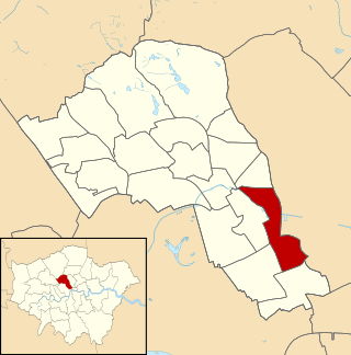
King's Cross is a ward of the London borough of Camden, in the United Kingdom. The ward has existed since the creation of the borough on 1 April 1965 and was first used in the 1964 elections. The population of the ward at the 2011 Census was 11,843. In 2018, the ward had an electorate of 7,274. The Boundary Commission projects the electorate to rise to 8,459 in 2025.

The London Borough of Camden is a London borough in Inner London, England. Camden Town Hall, on Euston Road, lies 1.4 mi (2.3 km) north of Charing Cross. The borough was established on 1 April 1965 and includes the former Central London borough of Holborn, and St Pancras and Hampstead.

Pancras Square Library is in the London Borough of Camden located just off the Euston Road in the King's Cross area of the borough. It is situated on the ground floor of Camden Council's Town Hall complex. With a separate children's library it provides a wide selection of books, CDs and DVDs available to borrow, and free internet access, making it central to provide a library service and gateway to other Council services to the local community.
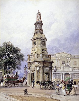
King's Cross was a short-lived building in London which gave its name to the area still known as Kings Cross. The building was erected in 1830, as the base for a memorial to the recently deceased King George IV. A statue of the late king was added in 1835, but then removed in 1842, and the structure was demolished in 1845.

Camley Street is a street in the London Borough of Camden in London, England. It lies in St Pancras and King's Cross: stretching over a kilometre from St Pancras railway station in the south, over the Regent's Canal, and to Agar Grove in the north.


