Schoharie County is a county in the U.S. state of New York. As of the 2020 census, the population was 29,714, making it the state's fifth-least populous county. The county seat is Schoharie. "Schoharie" comes from a Mohawk word meaning "floating driftwood." Schoharie County is part of the Albany-Schenectady-Troy, NY Metropolitan Statistical Area.

Gilboa is a town in Schoharie County, New York, United States. The population was 1,111 at the 2020 census.

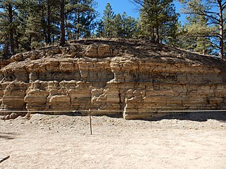
Petrified wood, also known as petrified tree, is the name given to a special type of fossilized wood, the fossilized remains of terrestrial vegetation. Petrifaction is the result of a tree or tree-like plants having been replaced by stone via a mineralization process that often includes permineralization and replacement. The organic materials making up cell walls have been replicated with minerals. In some instances, the original structure of the stem tissue may be partially retained. Unlike other plant fossils, which are typically impressions or compressions, petrified wood is a three-dimensional representation of the original organic material.
The Florissant Formation is a sedimentary geologic formation outcropping around Florissant, Teller County, Colorado. The formation is noted for the abundant and exceptionally preserved insect and plant fossils that are found in the mudstones and shales. Based on argon radiometric dating, the formation is Eocene in age and has been interpreted as a lake environment. The fossils have been preserved because of the interaction of the volcanic ash from the nearby Thirtynine Mile volcanic field with diatoms in the lake, causing a diatom bloom. As the diatoms fell to the bottom of the lake, any plants or animals that had recently died were preserved by the diatom falls. Fine layers of clays and muds interspersed with layers of ash form "paper shales" holding beautifully-preserved fossils. The Florissant Fossil Beds National Monument is a national monument established to preserve and study the geology and history of the area.

Schoharie Creek is a river in New York that flows north 93 miles (150 km) from the foot of Indian Head Mountain in the Catskills through the Schoharie Valley to the Mohawk River. It is twice impounded north of Prattsville to create New York City's Schoharie Reservoir and the Blenheim-Gilboa Power Project.

Archaeopteris is an extinct genus of progymnosperm tree with fern-like leaves. A useful index fossil, this tree is found in strata dating from the Upper Devonian to Lower Carboniferous, the oldest fossils being 385 million years old, and had global distribution.

Fossil wood, also known as fossilized tree, is wood that is preserved in the fossil record. Over time the wood will usually be the part of a plant that is best preserved. Fossil wood may or may not be petrified, in which case it is known as petrified wood or petrified tree. The study of fossil wood is sometimes called palaeoxylology, with a "palaeoxylologist" somebody who studies fossil wood.

New York State Route 990V (NY 990V) is an east–west reference route in Schoharie County, New York, in the United States. It extends for 6.15 miles (9.90 km) from an intersection with NY 30 in the town of Gilboa to a junction with County Route 18 (CR 18) in the town of Conesville, where the road continues east as CR 3. Reference routes in New York are typically unsigned; however, NY 990V is fully signed with touring route markers. The road is a remnant of New York State Route 342, a route assigned as part of the 1930 renumbering of state highways in New York. The NY 342 designation was removed in the late 1940s; however, its former routing from Gilboa to Conesville remained a state highway and became NY 990V when the modern reference route system in New York was created.

The Schoharie Reservoir is a reservoir in the Catskill Mountains of New York State that was created to be one of 19 reservoirs that supplies New York City with water. It was created by impounding Schoharie Creek. Portions of it lie in the towns of Conesville and Gilboa in Schoharie County, Roxbury in Delaware County, and Prattsville in Greene County.
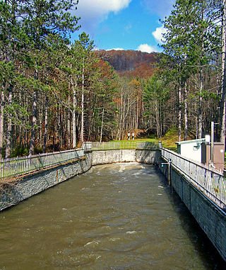
The Shandaken Tunnel is an aqueduct in Eastern New York State, part of the New York City water supply system. It was constructed between 1916 and 1924. The tunnel starts in Gilboa, New York at the Schoharie Reservoir, which is in the counties of Schoharie, Delaware, and Greene. The water flows south towards the Esopus Creek in Ulster County. It finally empties into a man-made pool in Allaben, New York, within the Town of Shandaken, and enters Esopus Creek there.
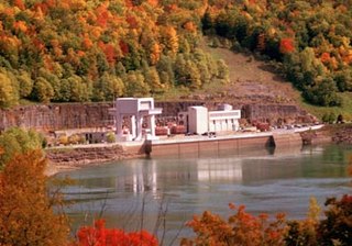
The Blenheim–Gilboa Pumped Storage Power Station is a pumped-storage hydroelectricity plant in the Catskill Mountains of New York State. The plant is part of the New York Power Authority, and can generate over 1,100 megawatts (1,500,000 hp) of electricity, all of which is sent to New York City. It is used daily to cover peak demand. There are two reservoirs that are involved in the project, both with a capacity of 5 billion US gallons (19,000,000 m3); one at the foot of Brown Mountain in the Schoharie Valley, and another one at the top of the mountain. The power station has an accumulated capacity of about 12,000 megawatt-hours (43,000 GJ) after storing up to 17,000 megawatt-hours (61,000 GJ).

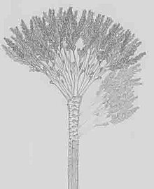
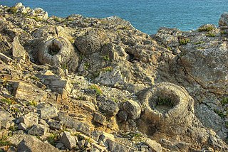
Wattieza was a genus of prehistoric trees that existed in the mid-Devonian that belong to the cladoxylopsids, close relatives of the modern ferns and horsetails. The 2005 discovery in Schoharie County, New York, of fossils from the Middle Devonian about 385 million years ago united the crown of Wattieza to a root and trunk known since 1870. The fossilized grove of "Gilboa stumps" discovered at Gilboa, New York, were described as Eospermatopteris, though the complete plant remained unknown. These fossils have been described as the earliest known trees, standing 8 m (26 ft) or more tall, resembling the unrelated modern tree fern.
The cladoxylopsids are an extinct group of plants related to ferns and sphenopsids.
Winifred Goldring, was an American paleontologist whose work included a description of stromatolites, as well as the study of Devonian crinoids. She was the first woman in the nation to be appointed as a State Paleontologist.
The Schoharie Valley is a corridor that runs through Schoharie County from Schoharie, New York to Gilboa, New York.
The Fossil Forest is the remains of an ancient submerged forest from Jurassic times, located to the east of Lulworth Cove on the Isle of Purbeck in Dorset, England. It lies on the Jurassic Coast, on a wide ledge in the seaside cliff. The site is within the Lulworth Ranges and thus has restricted access. Parts of forest can also be seen on the Isle of Portland and in quarries near the town of Weymouth to the west.

Specimen Ridge, el. 8,379 feet (2,554 m) is an approximately 8.5-mile (13.7 km) ridge along the south rim of the Lamar Valley in Yellowstone National Park. The ridge separates the Lamar Valley from Mirror Plateau. The ridge is oriented northwest to southeast from the Tower Junction area to Amethyst Mountain. The ridge is known for its abundance of amethyst, opal and petrified wood. It was referred to as Specimen Mountain by local miners and was probably named by prospectors well before 1870. The south side of the ridge is traversed by the 18.8-mile (30.3 km) Specimen Ridge Trail between Tower Junction and Soda Butte Creek. The trail passes through the Petrified Forest and over the summit of Amethyst Mountain el. 9,614 feet (2,930 m).

Paleontology in New York refers to paleontological research occurring within or conducted by people from the U.S. state of New York. New York has a very rich fossil record, especially from the Devonian. However, a gap in this record spans most of the Mesozoic and early Cenozoic.
Amethyst Mountain, el. 9,609 feet (2,929 m) is the highest peak and central part of a northwest – southeast trending ridge that lies between the Lamar River to the northeast and Deep Creek to the southwest within Park County, Wyoming. From northwest to southeast, this ridge consists of Specimen Ridge, Amethyst Mountain, and the Mirror Plateau in Yellowstone National Park. The nearest town is Silver Gate, Montana, which is 19.2 miles away.
The Panther Mountain Formation is a geologic formation in New York. It preserves fossils dating back to the Devonian period. It is located in the counties of Albany, Madison, Oneida, Otsego, and Schoharie. It is well known for its fossil arthropods preserved as flattened cuticles, including Attercopus and Dracochela.