Gladsmuir

Last updated

Gladsmuir
Gladsmuir Parish Church - geograph.org.uk - 171751.jpg
Gladsmuir Parish Church
East Lothian UK location map.svg
Red pog.svg
Gladsmuir
Scotland location map.svg
Red pog.svg
Gladsmuir
Location within Scotland
OS grid reference NT457732
Civil parish
  • Gladsmuir
Council area
Lieutenancy area
Country Scotland
Sovereign state United Kingdom
Post town TRANENT
Postcode district EH33
Dialling code 01875
Police Scotland
Fire Scottish
Ambulance Scottish
UK Parliament
Scottish Parliament
List of places
UK
Scotland
55°56′56″N2°52′05″W / 55.949°N 2.868°W / 55.949; -2.868

Gladsmuir is a village and parish in East Lothian, Scotland, situated on the A199 and near Tranent and Prestonpans.

Contents

Description

Gladsmuir's principal "claim to fame" relates to its role as the site of the Battle of Prestonpans (1745). Some sources – particularly maps – occasionally refer to the confrontation as the Battle of Gladsmuir. [1] The Jacobite poet William Hamilton (1704–1754) wrote a poem entitled Ode on the Battle of Gladsmuir, 1745 in celebration of the battle. [2]

The philanthropist George Heriot, jeweller to James VI, King of Scots and founder of Heriot's Hospital, (later George Heriot's School), in Edinburgh, may have been born in Gladsmuir, his father was. [3]

Scottish writer George Godfrey Cunningham (c. 1802–1860) lived at Redcol in Gladsmuir parish. [4]

Church

Old Gladsmuir Parish Kirk dates from some time between 1650 and the creation of the parish in 1695 and its ruins stand to the north of the current operational church. [5]

The replacement church is a Romanesque cruciform church dating from 1839 and designed by William Burn. The interior was destroyed by a fire in 1886 and restored by architect John Farquharson of Haddington with later improvements made in 1929. The older ruined kirk can still be seen and explored behind the new kirk. The graveyard contains interesting 18th century monuments and several CWGC graves from both world wars. [6]

The manse dates from 1871 and stands to the north-east. [7]

Notable Ministers

History

Gladsmuir parish was created in 1692 and in its original form it reached the southern shores of the Firth of Forth and extended to an area of 10 square miles. As well as the modern village of Gladsmuir the villages of Longniddry, Macmerry, Elvingston and Samuelston were within the newly created parish. The name Gladsmuir was originally 'Gledsmuir' and this name means 'the moor of the kite or hawk', gled being the Scots word for either a red kite or a common buzzard. There were limestone and coal deposits within the parish, as well as rich deposits of clay and iron and in the 19th century this was an industrial parish. Weaving dominated in Longniddry and Samuelston while there were iron works at Macmerry and limeworkings at Harlow. Distinctively white bricks and roof tiles were produced locally, while the coal mines employed 50 miners, in addition to 30 women and 36 boys in 1836. In the mid-20th century mining had mostly disappeared from the area; however, open-cast coal extraction continued at Blindwells up to the 1970s. The Great North Road between Edinburgh and London once passed through the parish, as does the railway lines to North Berwick and the south. In the 20th century Longniddry and Macmerry expanded and overtook Gladsmuir village in size and importance. [9]

Butterdean wood

Butterdean Wood is a mixed woodland of conifers and broad-leafed trees to the north of Gladsmuir which is owned by the Woodland Trust. It has a car park and two way-marked trails and contains a number of wildlife themed sculptures. [10]

Related Research Articles

<span class="mw-page-title-main">East Lothian</span> Council area of Scotland

East Lothian is one of the 32 council areas of Scotland, as well as a historic county, registration county and lieutenancy area. The county was called Haddingtonshire until 1921.

<span class="mw-page-title-main">Longniddry</span> Village in East Lothian, Scotland

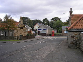
Longniddry is a coastal village in East Lothian, Scotland, with an estimated population of 2,340 in 2020. The Scottish Women's Rural Institute was founded here in 1917.

<span class="mw-page-title-main">Cockenzie and Port Seton</span> Town in East Lothian, Scotland

Cockenzie and Port Seton is a unified town in East Lothian, Scotland. It is on the coast of the Firth of Forth, four miles east of Musselburgh. The burgh of Cockenzie was created in 1591 by James VI of Scotland. Port Seton harbour was built by the 11th Lord Seton between 1655 and 1665.

<span class="mw-page-title-main">Haddington, East Lothian</span> Town in East Lothian, Scotland

The Royal Burgh of Haddington is a town in East Lothian, Scotland. It is the main administrative, cultural and geographical centre for East Lothian. It lies about 17 miles east of Edinburgh. The name Haddington is Anglo-Saxon, dating from the sixth or seventh century AD when the area was incorporated into the kingdom of Bernicia. The town, like the rest of the Lothian region, was ceded by King Edgar of England and became part of Scotland in the tenth century. Haddington received Burgh status, one of the earliest to do so, during the reign of David I (1124–1153), giving it trading rights which encouraged its growth into a market town.

<span class="mw-page-title-main">Tranent</span> Town in East Lothian, Scotland

Tranent is a town in East Lothian, in the south-east of Scotland. The town lies 6 miles from the boundary of Edinburgh, and 9.1 miles from the city centre. It lies beside the A1 road, the A1 runs through the parish splitting the parish from its associated villages and hamlets namely Meadowmill and the port of the parish Cockenzie. The original main post road ran straight through the town until the new A1 was built. Built on a gentle slope, about 90 metres (300 ft) above sea level it is one of the oldest towns in East Lothian. The population of the town is approximately 12,140, an increase of over 4,000 since 2001. Tranent was formerly a major mining town, but now serves as a commuter town for Edinburgh.

<span class="mw-page-title-main">Longniddry railway station</span> Railway station in East Lothian, Scotland

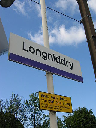
Longniddry railway station is located at the southeast corner of the coastal village of Longniddry, East Lothian, Scotland. The station is on the East Coast Main Line, 13+14 miles (21.3 km) east of Edinburgh Waverley, and is served by stopping passenger trains on the North Berwick Line.

<span class="mw-page-title-main">Macmerry</span> Village in East Lothian, Scotland

Macmerry is a village located on the old A1 just east of Tranent.

<span class="mw-page-title-main">Prestonpans</span> Human settlement in Scotland

Prestonpans is a small mining town, situated approximately eight miles east of Edinburgh, Scotland, in the council area of East Lothian. The population as of 2020 is 10,460. It is near the site of the 1745 Battle of Prestonpans. Prestonpans is "Scotland's Mural Town", with many murals depicting local history.

<span class="mw-page-title-main">Prestongrange Parish Church</span>

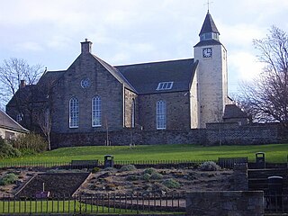
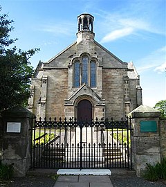
Prestongrange Parish Church is a Church of Scotland kirk situated in the small, former mining town of Prestonpans in East Lothian. The church was built in 1596, one of the first churches to be built in Scotland following the Scottish Reformation in 1560. In 1606, Prestonpans was created a parish in its own right following centuries of being part of the parish of Tranent.

<span class="mw-page-title-main">Bankton House</span> Historic site

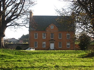
Bankton House is a late 17th-century house situated south of Prestonpans in East Lothian, Scotland. The house is located between the A1 road and the East Coast Main Line railway at grid reference NT394736.

The Macmerry Branch was a North British Railway built double track branch railway line in East Lothian, Scotland, that ran from a junction west of Inveresk on the East Coast Main Line to Macmerry via four intermediate stations, Smeaton, Crossgatehall Halt, Ormiston, and Winton. Two lines ran off the branch line, one a spur line to Hardengreen Junction on the Waverley Line from Smeaton, and the other a branch line to Gifford from just past Ormiston.

<span class="mw-page-title-main">2003 East Lothian Council election</span>

Elections to East Lothian Council were held on 1 May 2003, the same day as the other Scottish local government elections and the Scottish Parliament general election.

<span class="mw-page-title-main">1999 East Lothian Council election</span>

Elections to East Lothian Council were held on 6 May 1999, the same day as the other Scottish local government elections and the Scottish Parliament general election.

<span class="mw-page-title-main">1995 East Lothian Council election</span>

Elections to East Lothian Council were held on 6 April 1995, the same day as the other Scottish local government elections.

John Farquharson (1847–1933) was a Scottish architect operational in the late 19th century and early 20th century. He designed several schools in the East Lothian district.

<span class="mw-page-title-main">1992 East Lothian District Council election</span> Election in 1992, part of Scotland wide district council elections

Elections to the East Lothian District Council took place in May 1992, alongside elections to the councils of Scotland's various other districts.

Elections for the East Lothian Council took place in May 1988, alongside elections to the councils of Scotland's various other districts.

Elections for East Lothian District Council took place on Thursday 3 May 1984, alongside elections to the councils of Scotland's various other districts.

The 1980 East Lothian District Council election for the East Lothian Council took place in May 1980, alongside elections to the councils of Scotland's various other districts.

References

  1. Ben Johnson. "Battle of Prestonpans". Historic UK Ltd. Retrieved 24 March 2020.
  2. "Ode on the Battle of Gladsmuir, 1745". Poetry Nook. Retrieved 24 March 2020.
  3. "Gladsmuir". Gazetteer for Scotland. Retrieved 24 March 2020.
  4. East Lothian Annual Register. Haddington: Neill & Sons. 1848. p. 17.
  5. Historic Environment Scotland. "Gladsmuir, Old Parish Church (54970)". Canmore . Retrieved 24 March 2020.
  6. Historic Environment Scotland. "Gladsmuir Parish Church with graveyard gatepiers and gates (LB12709)" . Retrieved 24 March 2020.
  7. Historic Environment Scotland. "Gladsmuir Dragonswell with garden building (LB12705)" . Retrieved 24 March 2020.
  8. Fasti Ecclesiae Scoticanae; by Hew Scott
  9. "Gladsmuir". John Gray Centre. East Lothian Council. Retrieved 24 March 2020.
  10. "Butterdean Wood". Woodland Trust. Retrieved 24 March 2020.