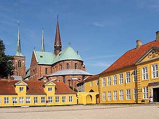
Roskilde is a city 30 km (19 mi) west of Copenhagen on the Danish island of Zealand. With a population of 52,974, the city is a business and educational centre for the region and the 10th largest city in Denmark. It is governed by the administrative council of Roskilde Municipality.

Nyborg is a city in central Denmark, located in Nyborg Municipality on the island of Funen and with a population of 17,900 (2023). It is the easternmost settlement on Funen. By road, it is located 34 km east of Odense, 35 km north of Svendborg and 21 km south of Kerteminde. It also connects to Korsør through the Great Belt Bridge. Nyborg is the seat of Nyborg Municipality, and until 1793 it was also the seat of Nyborg County.
Glostrup Municipality is a suburban municipality and town in Region Hovedstaden on the island of Zealand (Sjælland) approx. 10 km west of Copenhagen in eastern Denmark. The municipality covers an area of 13.31 km2, and has a total population of 23,655 (2024). Its Zip code (Postnummer) is 2600. Its mayor as of 2022 is Kasper Damsgaard, a member of the Social Democrats (Socialdemokratiet) political party. The municipality was established in 1841 following the municipal reforms of the 1840s, ranking as a parish municipality (sognekommune) until 1950 when suburbanisation of Copenhagen inhabited the municipality and the status was changed to town municipality (købstadskommune). From 1947 to 1960 the population in the municipality doubled due to the expanding suburbs of Copenhagen, reaching the municipality in the post-war period. Glostrup was designated as a new suburb along the western Tåstrup-finger of the Copenhagen Finger Plan of 1947.

Høje-Taastrup Municipality is a municipality in the Capital Region on the island of Zealand (Sjælland) in eastern Denmark. The municipality covers an area of 78 km2 (30 mi2), and has a total population of 57,540. It was formed by the 1970 Danish Municipal Reform, and its 1974 adjustment, by merging the parish municipalities of Høje Taastrup, Sengeløse, the Fløng part of Hvedstrup-Fløng and the Reerslev part of Reerslev-Vindinge. Since 1 January 2006 the mayor of the municipality has been Michael Ziegler, a member of the Conservative People's Party political party.

Holbæk is a town in Denmark and the seat of Holbæk municipality with a population of 29,960. It is located in the northwestern part of Region Sjælland, Denmark.

Kongens Lyngby is the seat and commercial centre of Lyngby-Taarbæk Municipality in the northern suburbs of Copenhagen, Denmark. Lyngby Hovedgade is a busy shopping street and the site of a branch of Magasin du Nord as well as Lyngby Storcenter. The district is also home to several major companies, including COWI A/S, Bang & Olufsen, ICEpower a/s and Microsoft. The Technical University of Denmark relocated to Lyngby from central Copenhagen in the 1970s. Lyngby station is located on the Hillerød radial of Copenhagen's S-train network.
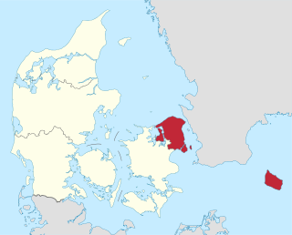
The Capital Region of Denmark is the easternmost administrative region of Denmark, and contains Copenhagen, the national capital.

Valby ( ) is one of the 10 official districts of Copenhagen Municipality, Denmark. It is in the southwestern corner of Copenhagen Municipality, and has a mixture of different types of housing. This includes apartment blocks, terraced housing, areas with single-family houses and allotments, plus the remaining part of the old Valby village, around which the district has formed, intermingled with past and present industrial sites.

Glostrup station is a commuter rail railway station serving the railway town/suburb of Glostrup west of Copenhagen, Denmark. It is located close to the historical, administrative and commercial centre of Glostrup Municipality, but also serves Brøndbyvester in Brøndby Municipality, the boundary of which comes within a few hundred metres from the station. The station is connected to the nearby Glostrup Shopping Center via an underground walkway, the same walkway which is used to access the platforms.

Hedehusene is a suburban town located on the rail line between Copenhagen and Roskilde in the Capital Region of Denmark. It has absorbed the villages of Baldersbrønde and Fløng and almost merged with Roskilde's eastern Trekroner neighbourhood to the west and Høje Taastrup to the east. To the south is the large recreational area Hedeland. As of 1 January 2023, the town had a population of 14,868. A large development project, NærHeden, created as a collaboration between Høje-Taastrup Municipality and Realdania, will expand the town to the southeast with a new sustainable neighbourhood.

Frederiksberg is a part of the Capital Region of Denmark. It is an independent municipality, Frederiksberg Municipality, separate from Copenhagen Municipality, but both are a part of the neighborhood of Copenhagen. It occupies an area of less than 9 km2 and had a population of 103,192 in 2015.

Rødovre is a town in eastern Denmark, seat of the Rødovre Municipality, in the Region Hovedstaden. The town's population 1 January 2019 was 39,907, and in addition 145 persons had no fixed address, which made up a total of 40,052 in the municipality as a whole. Rødovre is part of the urban area of Copenhagen.
Lemvig is a market town located on the Limfjord in North Jutland, Denmark. The town has a population of 6,827 (2023)., and is the seat of Lemvig Municipality in the North Jutland Region.

Køge is a seaport on the coast of Køge Bugt 39 km southwest of Copenhagen. It is the principal town and seat of Køge Municipality, Region Sjælland, Denmark. In 2023, the urban area had a population of 38,588.

The Finger Plan is an urban plan from 1947 which provides a strategy for the development of the Copenhagen metropolitan area, Denmark. According to the plan, Copenhagen is to develop along five 'fingers', centred on S-train commuter rail lines, which extend from the 'palm', that is the dense urban fabric of central Copenhagen. In between the fingers, green "wedges" are intended to provide land for agriculture and recreational purposes.
Borup is a railway town in Zealand, Denmark. It lies about 40 km southwest of Copenhagen on the railroad between Roskilde and Ringsted. It is located in Køge Municipality in Region Zealand. With a population of 4,833, it is the second largest town of the municipality.

Roskildevej is a road between Copenhagen and Roskilde in the Danish capital area. The direct continuation of Vesterbrogade, which begins at Copenhagen's City Hall Square, the road begins at Pile Allé and continues through Frederiksberg, Valby, Rødovre, Glostrup, Albertslund, Taastrup and Hedehusene to Roskilde. The section between Hedehusene and Roskilde is now known as Københavnsvej and in Hedehusene and Glostrup it is simply known as Hovedgaden.
Transport in Copenhagen and the surrounding area relies on a well-established infrastructure making it a hub in Northern Europe due to its road and rail networks as well as its international airport. Thanks to its many cycle tracks, Copenhagen is considered one of the world's most bicycle-friendly cities. The metro and S-train systems are key features of the city's well-developed public transport facilities. Since July 2000, the Øresund Bridge has served as a road and rail link to Malmö in Sweden. The city is also served by ferry connections to Oslo in Norway while its award-winning harbour is an ever more popular port of call for cruise ships.

Greater Copenhagen Light Rail is a planned electric light rail system crossing the lines of the S-train in Greater Copenhagen, Denmark, parallel to but outside the borders of Copenhagen Municipality. Its first stage is known as the Ring 3 Light Rail, for which construction started in 2018. It will go from Lundtofte Park north of Copenhagen to Ishøj station in the southwest, and it is expected to open in 2025, with an annual ridership of 13-14 million projected. The line will be owned by the Ringby-Letbanesamarbejdet, which is a collaboration between the municipalities serviced or affected by the line.

Ølstykke-Stenløse is a city located in the Egedal Municipality, in the Capital Region of Denmark. Both Ølstykke and Stenløse has been counted as one city by Statistics Denmark from 1 January 2010, and it forms the eastern part of the city closest to Copenhagen, 25 kilometers in a straight line northwest of City Hall Square, as well as Gammel Ølstykke and Ølstykke Stationsby in the west. It is Denmark's 29th largest city (2023), with a population of 23,130 (2023). It is the largest city in Egedal Municipality and more than half of the municipality's residents live within the city.


