Goodman's Buildings

Last updated

Goodman's Buildings
Goodman's Buildings.jpg
Goodman's Buildings, 2019
Location2-12 Johnston Street, Annandale, Inner West Council, Sydney, New South Wales, Australia
Coordinates 33°53′15″S151°10′03″E / 33.8876°S 151.1674°E / -33.8876; 151.1674 Coordinates: 33°53′15″S151°10′03″E / 33.8876°S 151.1674°E / -33.8876; 151.1674
Official name: Goodman's Buildings
Typestate heritage (built)
Designated2 April 1999
Reference no.672
TypeShop
CategoryRetail and Wholesale
Location map Australia Sydney.png
Red pog.svg
Location of Goodman's Buildings in Sydney

Goodman's Buildings is a heritage-listed retail building at 2-12 Johnston Street, Annandale, Inner West Council, Sydney, New South Wales, Australia. It was added to the New South Wales State Heritage Register on 2 April 1999. [1]

Annandale, New South Wales Suburb of Sydney, New South Wales, Australia

Annandale is a suburb in the Inner West of Sydney, in the state of New South Wales, Australia. Annandale is located within 5 kilometres west of the Sydney central business district and is part of the local government area of the Inner West Council. Annandale's northern end lies on Rozelle Bay, which is on Sydney Harbour. Glebe lies to its east, Lilyfield and Leichhardt to its west and Stanmore to its south.

Inner West Council Local government area in New South Wales, Australia

Inner West Council is a local government area located in the inner western region of Sydney in the state of New South Wales, Australia. The Council was formed on 12 May 2016 from the forced merger of the former Ashfield, Leichhardt, and Marrickville councils.

Sydney City in New South Wales, Australia

Sydney is the state capital of New South Wales and the most populous city in Australia and Oceania. Located on Australia's east coast, the metropolis surrounds Port Jackson and extends about 70 km (43.5 mi) on its periphery towards the Blue Mountains to the west, Hawkesbury to the north, the Royal National Park to the south and Macarthur to the south-west. Sydney is made up of 658 suburbs, 40 local government areas and 15 contiguous regions. Residents of the city are known as "Sydneysiders". As of June 2017, Sydney's estimated metropolitan population was 5,230,330 and is home to approximately 65% of the state's population.

Contents

History

Annandale was to be a "model township". The developer, John Young, created the 100 feet (30 m) wide boulevard along the main ridge, Johnston Street, which was intended to be the finest street in the Colony and encouraged the symmetrical street grid pattern. Walter Goodman, a local shoe merchant and entrepreneur, chose the site to construct a large emporium. Designed by prominent architects, Sheerin and Hennessy the building was built in stages between 1890 and 1912. The stepped elements in the building facades give some indication of the staged construction, with the Johnston Street frontage and corner being part of the first stage. On completion of the building Mr Goodman occupied a grand apartment on the first floor and leased out his ground floor shops. [2]

In the late 1980s the NSW Department of Planning co-ordinated the restoration of the exterior of the building as part of a scheme to improve the Parramatta Road streetscape. The works at this time included the repair of the verandah structures, essential repairs and painting of the buildings’ exterior. Paint scrapes were undertaken to determine the earlier colours which were found in the Pascol Paint range. Pascol donated over 700 litres of paint to complete the project. It would appear that a number of changes have been carried out, particularly to the rear of the buildings. The building is now occupied by a number of separate owners and tenants. [2]

The New South Wales Department of Planning and Environment was a department of the New South Wales Government between 2014 and 2019, responsible for effective and sustainable planning to support the growth in the state of New South Wales, Australia. Up until its abolition, it made plans based on evidence for the state’s cities and regions, working with the community, business and local government to create places for people in NSW to live, work and spend their leisure time, while ensuring good access to transport and other services like shops and restaurants. The Department was also responsible for the evidence-based assessment of state significant development applications. In 2015-16 the Department approved major projects worth A$20 billion.

Parramatta Road road in Sydeny

Parramatta Road is the major historical east-west artery of metropolitan Sydney, Australia, connecting the Sydney CBD with Parramatta. It is the easternmost part of the Great Western Highway. Since the 1980s its role has been augmented by the City West Link Road and Motorway M4.

Description

Goodman's Buildings is a two-storey rendered brick commercial and residential building with Victorian Filigree details, high parapet and façade which curves around the Parramatta Road and Johnston Street corner. The building houses thirteen separate shops and residences above with renovated shopfronts on the ground floor with suspended awnings and narrow balconies over on the Parramatta Road frontage and wide posted balconies along the Johnston Street frontage. The first floor balconies all feature cast iron lace balustrade and posts which support the corrugated iron roof (ogee profile). Large double hung timber framed windows are regularly spaced along the first floor facades topped by rendered cornice and mouldings and bayed parapet with moulded cement balustrade and decorative urns at the end of each bay. A pediment bearing the name of the building is located at the western end of the Parramatta Road façade, corner and northern end of the Johnston Street façade. The façades and parapet conceal the skillion roof forms and rear wings which extend back to Albion Lane. [2]

Parapet barrier which is an extension of the wall at the edge of a roof, terrace, balcony, walkway or other structure

A parapet is a barrier which is an extension of the wall at the edge of a roof, terrace, balcony, walkway or other structure. The word comes ultimately from the Italian parapetto. The German equivalent Brüstung has the same meaning. Where extending above a roof, a parapet may simply be the portion of an exterior wall that continues above the edge line of the roof surface, or may be a continuation of a vertical feature beneath the roof such as a fire wall or party wall. Parapets were originally used to defend buildings from military attack, but today they are primarily used as guard rails and to prevent the spread of fires.

Significance

The Goodman's Buildings are of high historic, aesthetic and social significance as a relatively rare example of a grand emporium style building constructed in the inner city from 1890. The building is a largely intact example of a Victorian styled building constructed from 1890 that retains its overall scale, character and details particularly the first floor balconies and distinctive parapet and pediments. The building occupies a prominent corner site and has landmark qualities and makes a positive contribution to this part of the Parramatta Road and Johnston Street streetscapes. [2]

Heritage listing

Goodman's Buildings was listed on the New South Wales State Heritage Register on 2 April 1999. [1]

New South Wales State Heritage Register

The New South Wales State Heritage Register, also known as NSW State Heritage Register, is a heritage list of places in the state of New South Wales, Australia, that are protected by New South Wales legislation, generally covered by the Heritage Act, 1977 (NSW) and its 2010 amendments. The register is administered by the NSW Office of Environment and Heritage, a division of the Government of New South Wales Department of Planning and Environment.

See also

Related Research Articles

Downing Centre

The Downing Centre is a major heritage-listed former department store and now courthouse complex in Sydney, New South Wales, Australia. It features state government courts, including the Local Court, the District Court, and a law library known as the Downing Centre Library. The Downing Centre forms part of the Department of Justice and houses court services and sheriffs offices.

Hunters Buildings

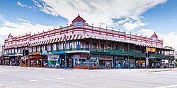
Hunters Buildings is a heritage-listed group of commercial buildings at 179 - 191 George Street, Brisbane City, City of Brisbane, Queensland, Australia. The individual buildings are Treasury Chambers, St Francis House, and Symons Building. They were designed by Richard Gailey and built in 1886 by George Gazzard. They were added to the Queensland Heritage Register on 21 October 1992.

Annandale Post Office

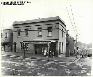
The Annandale Post Office is a post office located at 115-117 Booth Street, on the junction with Johnston Street, in Annandale, a suburb of Sydney, New South Wales, Australia. The post office is owned and operated by Australia Post, an agency of the Australian Government.

Parramatta Town Hall

The Parramatta Town Hall is an heritage-listed town hall located in the Sydney suburb of Parramatta, New South Wales, Australia. Designed by Messrs Blackmann and Parkes in the Victorian Free Classical architectural style, the town hall was completed in 1883 at a cost of A£2,300 to serve as the town hall and municipal chamber for the Borough of Parramatta.

Tamworth Peel Barracks

The Tamworth Peel Barracks is an heritage-listed historic site located at 214 Peel Street, Tamworth, Tamworth Regional Council, New South Wales, Australia. The property is owned by Tamworth Regional Council and was added to the New South Wales State Heritage Register on 2 April 1999.

Substation No. 15

Substation No. 15 is a heritage-listed electrical substation at 182 Johnston Street, Annandale, Inner West Council, Sydney, New South Wales, Australia. It was built in 1910. The property is owned by Ausgrid. It was added to the New South Wales State Heritage Register on 2 April 1999.

Brooklyn Hotel, The Rocks

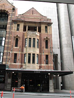
The Brooklyn Hotel is a heritage-listed bar and restaurant and former hotel located at 229 George Street, in the inner city Sydney suburb of The Rocks in the City of Sydney local government area of New South Wales, Australia. It was designed by Walter Liberty Vernon and built in 1912. The property is owned by Property NSW, an agency of the Government of New South Wales. It was added to the New South Wales State Heritage Register on 10 May 2002.

Butchery Building

The Butchery Building is a heritage-listed restaurant and former terraced houses and butcher's shop located at 178-180 Cumberland Street, in the inner city Sydney suburb of The Rocks in the City of Sydney local government area of New South Wales, Australia. It was built from 1890 to 1899. It is also known as The Butchery Buildings. The property is owned by Property NSW, an agency of the Government of New South Wales. It was added to the New South Wales State Heritage Register on 10 May 2002.

182.5-188 Cumberland Street, The Rocks

182.5-188 Cumberland Street, The Rocks are a series of heritage-listed terrace houses located at 182.5-188 Cumberland Street, in the inner city Sydney suburb of The Rocks in the City of Sydney local government area of New South Wales, Australia. It was built during 1890 by William John Finneran. The property is owned by Property NSW, an agency of the Government of New South Wales. It was added to the New South Wales State Heritage Register on 10 May 2002.

145 George Street, The Rocks

145 George Street, The Rocks is a heritage-listed duty-free store complex and former retail building and residence located at 145 George Street, in the inner city Sydney suburb of The Rocks in the City of Sydney local government area of New South Wales, Australia. It was built in 1892. It is also known as Currently part of Duty Free Store complex. The property is owned by Property NSW, an agency of the Government of New South Wales. It was added to the New South Wales State Heritage Register on 10 May 2002.

Winsbury Terrace "Heritage place or item located at 75, 77, 79 Kent Street Millers Point New South Wales, Australia"

Winsbury Terrace are heritage-listed terrace houses located at 75-79 Kent Street, in the inner city Sydney suburb of Millers Point in the City of Sydney local government area of New South Wales, Australia. It was built from 1875. The property was added to the New South Wales State Heritage Register on 2 April 1999.

28 Lower Fort Street, Millers Point

28 Lower Fort Street, Millers Point is a heritage-listed former residence and now boarding house at 28 Lower Fort Street, in the inner city Sydney suburb of Millers Point in the City of Sydney local government area of New South Wales, Australia. The property was added to the New South Wales State Heritage Register on 2 April 1999.

115-121 Kent Street, Millers Point

115-121 Kent Street, Millers Point are heritage-listed terrace houses located at 115-121 Kent Street, in the inner city Sydney suburb of Millers Point in the City of Sydney local government area of New South Wales, Australia. The property was added to the New South Wales State Heritage Register on 2 April 1999.

Hawken and Vance Produce Exchange

Hawken and Vance Produce Exchange is a heritage-listed commercial building facade at 95-99 Sussex Street, Sydney, City of Sydney, New South Wales, Australia. It was built in 1883, with the remainder of the building apart from the facade being demolished in 1989. It was added to the New South Wales State Heritage Register on 2 April 1999.

Kings Hotel, Sydney CBD

Kings Hotel is a heritage-listed former pub and now commercial premises located at 138-140 Pitt Street, in the Sydney central business district, in the City of Sydney local government area of New South Wales, Australia. It was built from 1879. It is also known as Trickett's Hotel and Sugar House. It was added to the New South Wales State Heritage Register on 2 April 1999.

National House

National House is a heritage-listed former warehouse and bank branch and now pub located at 75 York Street, on the corner of King Street, in the Sydney central business district, in the City of Sydney local government area of New South Wales, Australia. It now operates as the Hotel CBD. It was added to the New South Wales State Heritage Register on 2 April 1999.

Grahames Corner

Grahame's Corner is a heritage-listed commercial and office building located at 142-144 Pitt Street, in the Sydney central business district, in the City of Sydney local government area of New South Wales, Australia. It was designed by G. A. Morell and built from 1877 to 1882. It is also known as Grahams Corner and the AMFIS Building. The property was added to the New South Wales State Heritage Register on 2 April 1999.

Metters Building Heritage listed building in Sydney, New South Wales, Australia

The Metters Building is a heritage-listed office building at 154-158 Elizabeth Street, in the Sydney central business district, in the City of Sydney local government area of New South Wales, Australia. It was designed by Robertson and Marks and built by W. Gawne & Sons in 1914. It was added to the New South Wales State Heritage Register on 2 April 1999.

Clarence Street Police Station former police station in Sydney, Australia

The Clarence Street Police Station is a heritage-listed former police station and now community service office located at 281 Clarence Street, in the Sydney central business district, in the City of Sydney local government area of New South Wales, Australia. It was designed by James Barnet as the NSW Government Architect and was built from 1890 to 1928. It was added to the New South Wales State Heritage Register on 2 April 1999.

References

  1. 1 2 "Goodman's Buildings". New South Wales State Heritage Register . Office of Environment and Heritage. H00672. Retrieved 2 June 2018.
  2. 1 2 3 4 "Goodman's Buildings". State Heritage Inventory. Office of Environment and Heritage. Retrieved 29 September 2018.

Attribution

Commons-logo.svg Media related to Goodman's Buildings at Wikimedia Commons