Parramatta Road

Last updated

Parramatta Road

Parramatta Road near University of Sydney.jpg
Parramatta Road
General information
TypeRoad
Length23 km (14 mi)
Opened1811
Route number(s)
Former
route number
see Former route allocations
Major junctions
East endAUS Alphanumeric Route A22.svg Broadway
Chippendale, Sydney
 
West endAUS Alphanumeric Route A44.svg Church Street
Granville, Sydney
Location(s)
Major suburbs Ultimo, Chippendale, Glebe, Camperdown, Forest Lodge, Annandale, Stanmore, Leichhardt. Petersham, Lewisham, Haberfield, Summer Hill Ashfield. Five Dock, Croydon, Concord, Burwood, Strathfield, Homebush, Auburn

Parramatta Road is the major historical east-west artery of metropolitan Sydney, New South Wales, Australia, connecting the Sydney CBD with Parramatta. It is the easternmost part of the Great Western Highway. Since the 1990s its role has been augmented by the City West Link and M4 Motorway.

Contents

The road begins in the east as a continuation of George Street, which becomes Broadway west of Harris Street, and Parramatta Road west of the City Road junction, and ends at the junction with Church Street in Parramatta. Its 23 kilometres (14 mi) distance is dominated by caryards and small marginally-viable shops. At the same time, however, it has over 100 abandoned and derelict stores. [1] [2] Owing to this and its abrasively noisy traffic, it has rarely been considered beautiful. [3]

Opened in 1811, it is one of Sydney's oldest roads and Australia's first road between two cities (before Sydney and Parramatta coalesced). As at 2015, over three million commuters every year drove Parramatta Road. [4] The road is the hub of Sydney's motor dealership industry - with 67% of the adjacent land used for motor retailing and services.

History

1790s–1800s: Development

A carriage marked "Ashfield-Burwood" trundles down Parramatta Road in the early 1870s, with the University of Sydney in the background. Parramattard1870susyd.jpg
A carriage marked "Ashfield-Burwood" trundles down Parramatta Road in the early 1870s, with the University of Sydney in the background.

British settlement in Parramatta began in the same year (1788) as it did in Sydney. The Parramatta River was used as navigation between them. Sometime between 1789 and 1791 an overland track was made to provide an official land route between the two settlements. [5]

Parramatta Road dates to the 1792 formation of a route linking Sydney to the settlement of Parramatta. This route was formalised under the direction of Surveyor–General Augustus Alt in 1797. Parramatta Road became one of the colony's most important early roads, and for many years remained one of Sydney's principal thoroughfares. [6] The early road was a poorly built and poorly maintained track through bush. In 1794, the governor of the colony reported that he had caused a very good road to be made, but there is no evidence that any bridges were built over the streams. The road subsequently deteriorated and on 9 June 1805 the Sydney Gazette reported that the road was impassable as the result of heavy rain. Attempts to improve the road continued over the years. [7]

1810–1815

By 1811, Parramatta Road had officially opened to traffic and was financed during a large portion of the 19th century by a toll, with toll booths located at what now is Sydney University and the Duck River. Governor Macquarie called tenders for the repair of the road, raised a three shilling per gallon levy on spirits and levied a toll to pay for the work. The road was to be 10 metres wide. This turnpike road was opened on 10 April 1811. The toll barriers were at the present Railway Square and at Becket's Creek (near Parramatta).[ citation needed ]

In 1814, a stage cart service was established along Parramatta Road. Fares were 10 shillings for passengers and 3 pence for letters. Heavy rain again nearly destroyed this road, so in 1817 it was announced that all tree-stumps would be removed and the road paved with stone which would be covered with earth and gravel. This improvement was announced as finished on 15 January 1815.[ citation needed ]

In 1815 the "profit" from the Sydney toll reached £465. The growth of Sydney caused the toll barrier to be moved to Grose Farm (present University of Sydney) in April 1836. In 1839 it was moved further west to Annandale.[ citation needed ]

1820s–1880s

Parramatta Road in the 1930s looking east across Iron Cove Creek towards Lewisham ParramattaRd1938.jpg
Parramatta Road in the 1930s looking east across Iron Cove Creek towards Lewisham

The colony's first stage coach (valued at £300) was imported in 1821 but did not begin regular service until 1823. The stage left the city at 7:00 am, arrived in Parramatta at 9:30 am and left Parramatta for the return journey at 4:00 pm. Inside passengers were charged six shillings. Hazards on the road included the threat of attacks by Indigenous people and bushrangers. Hotels and settlements sprang up along the road to serve coaching traffic. [8]

The importance of the road declined with the advent of the Sydney-Parramatta railway in 1855. In 1883, a steam tram line opened along Parramatta Road as far as Annandale, and was extended onward to Norton Street in 1884, where it turned to run along Norton Street to Short Street.

In the 1800s, the government acquired a strip of land from Ashfield to Burwood from the Rosebank Estate, owned by the Sisters of the Good Samaritan, Australia's first religious congregation. Rosebank College now stands on the former Rosebank Estate, and the heritage-listed building of the private school stands adjacent to the road at Five Dock.

1900s–present: Motorisation

Sydney Municipal Council began widening the major routes into the city centre in 1911, including the construction of Broadway and the widening of the cutting on Parramatta Road adjacent to Sydney University. In the 1920s, the road was sealed and tramlines were removed from the road. Sheep and cattle were still crossing Parramatta Road at Homebush as late as the 1960s.

Increased traffic congestion along the road steadily made it less attractive for residential and commercial use during the 20th century. By the last quarter of the 20th century, the only active businesses on many stretches of the road were car dealerships. The decline of industry in the Inner West also drove the decline of commercial areas formerly catering to factory workers. By the end of the 20th century, proposals to revitalise Parramatta Road and make it more attractive were regularly made.

One of these proposals was made in 2012, which would have widened and lowered the road below street level in a "slot" as part of the Roads & Maritime Services WestConnex motorway proposal. This plan was abandoned, and the WestConnex proposal was later changed to a pair of tunnels parallel to Parramatta Road and connecting to the existing M4 motorway. The new extension was known as M4 East and was eventually built between the end of the existing M4 motorway in North Strathfield and Haberfield, where it connected to the A4 road. The new tunnels opened to traffic in July 2019. [9] [10] The project resulted in the creation of a new entry and exit ramp on Parramatta Road in Ashfield, the narrowing of westbound traffic lanes for through-traffic to one lane at either end of the tunnel, and the demolition of a large number of houses in Ashfield and Haberfield to make way for the tunnel ramps.

Criticism

Homebush Cinema, built in 1925, is one of the many derelict establishments on the road, which operated until 1996 as a reception centre. Homebush Cinema.JPG
Homebush Cinema, built in 1925, is one of the many derelict establishments on the road, which operated until 1996 as a reception centre.

The road has been criticised by the community for its traffic pollution, congestion, and for its vacant shops and rundown buildings, particularly between Leichhardt and Concord, and local government has been accused of failing to adopt policies to encourage the redevelopment and regeneration of vacant sites. [11]

A local mayor described it as a "varicose vein". [12] A NSW Business Chamber Executive Patricia Forsythe said that the road is "one of the least attractive commercial areas of Sydney". Former NSW premier Nick Greiner thought the road looked "like Beirut on a bad day". The Sydney Morning Herald writer Elizabeth Farrelly described it as "filthy, noisy, sclerotic and dull". [13] On a lighter note, Tess De Quincey, an Australian performer/director said, "Every chapter of Sydney's history has been written on Parramatta Road." [14] A Sydney Morning Herald editor said that whilst the road is "ugly in parts, drab in others, and generally unpleasant", it is still "fundamental to the economic and social viability of the greater city". [15]

Since the 1970s many buildings fronting Parramatta Road, especially those in the prime locations of the Inner West (from Newtown to Homebush), have become vacant and fallen into disrepair, with many vandalised. Previously these buildings were a major part of local life for the suburbs along Parramatta Road, providing employment, retailing and other services. The buildings with graffiti and broken windows provide a sight that is sought out by graffiti vandals and proficient urban photographers. [16]

Nicholas Munning, an owner of a music store in Annandale, described the road as, "A lost cause...You can see the hodgepodge of buildings - abandoned buildings, abandoned shops - [with people thinking] let’s just let this sit here for four years until we get council approval to knock it down and build apartments...They don’t care if it sits there vacant with broken windows and looks like shit, The problem is the whole road looks like that. So nobody is going to say, 'hey, this is a great area. I’m going to spend $x making a really classy looking shop or restaurant'.” [17]

Redevelopment plan

The Government of New South Wales published the 'Parramatta Road Urban Transformation Strategy' in 2016, with a 30-year plan for redeveloping the area through planning and infrastructure investment. [18] Among the strategy's goals are housing an additional 56,000 people in 27,000 new homes on the corridor (with minimum five percent affordable housing); 50,000 workers employed in the area; and 66 hectares of new open space is provided through linear parks and along watercourses or infrastructure. [19]

The proposed development rights are worth millions of dollars to developers but are also controversial due to the density of some of the proposals and the likely impact on an already over-congested road. As a result, many of the development proposals are controversial with local residents and are opposed by local councils. A number of the disputes between developers and councils have led to court disputes. [17]

The Inner West Council and City of Canada Bay, through which the road runs for much of its length, have proposed using an electric guided bus running on the centre of the road for public transport, as opposed to kerbside buses as suggested in the strategy. [20]

Location

Parramatta Road looking west at Burwood, near Rosebank College, during peak hour Parramatta Road at Burwood.JPG
Parramatta Road looking west at Burwood, near Rosebank College, during peak hour

The highway forms the boundaries of various suburbs along the way and ends at the junction of Church Street, Parramatta, where the Great Western Highway briefly turns to the north. Parramatta Road forms the southern boundary of the following suburbs:

Parramatta Road forms the northern boundary of the following suburbs:

West of Concord and Burwood, Parramatta Road passes through Strathfield, Homebush, Auburn and Granville before reaching Parramatta.

Former route numbers

Parramatta Road has many former route allocations including former National Route 32. [21] [22] [23] [24] Where and when the former route numbers were implemented are stated below.

ChippendaleSummer Hill:

Summer HillHaberfield:

HaberfieldNorth Strathfield:

North StrathfieldAuburn:

AuburnClyde:

ClydeGranville:

Related Research Articles

<span class="mw-page-title-main">Homebush, New South Wales</span> Suburb of Sydney, New South Wales, Australia

Homebush is a suburb in the Inner West of Sydney in the state of New South Wales, Australia. It is located 12 kilometres west of the Sydney central business district, in the local government area of the Municipality of Strathfield.

<span class="mw-page-title-main">Great Western Highway</span> Highway in New South Wales

Great Western Highway is a 202-kilometre-long (126 mi) state highway in New South Wales, Australia. From east to west, the highway links Sydney with Bathurst, on the state's Central Tablelands.

<span class="mw-page-title-main">Inner West</span> Region in New South Wales, Australia

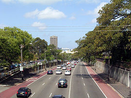
The Inner West of Sydney is an area directly west of the Sydney central business district, New South Wales, Australia. The suburbs that make up the Inner West are predominantly located along the southern shore of Port Jackson, stretching south to the shores of the Cooks River. The western boundary of the Inner West is approximately the A3 arterial road, which divides the Inner West from the Greater Western Sydney region. The Inner West is much larger than the Inner West Council local government area. The Inner West roughly corresponds with the Parish of Petersham and Parish of Concord, two cadastral divisions used for land titles.

<span class="mw-page-title-main">A4/M4 (Sydney)</span> Road route in New South Wales, Australia

The A4, A44 and M4 are a collection of arterial routes in Sydney, New South Wales that connect the Inner West of Sydney with the outer western suburbs.

<span class="mw-page-title-main">Haberfield, New South Wales</span> Suburb of Sydney, New South Wales, Australia

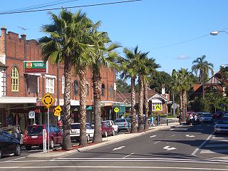
Haberfield is a suburb in the Inner West of Sydney, in the state of New South Wales, Australia. Haberfield is located 6.5 kilometres west of the Sydney central business district in the local government area of the Inner West Council.

<span class="mw-page-title-main">A3 (Sydney)</span>

The A3 is a route designation of a major metropolitan arterial route through suburban Sydney, connecting the A8 at Mona Vale at its northern end, to Princes Highway at Blakehurst at its southern end. This name covers a few consecutive roads and is widely known to most drivers, but the entire allocation is also known – and signposted – by the names of its constituent parts: Mona Vale Road, Ryde Road, Lane Cove Road, Devlin Street, Church Street, Concord Road, Homebush Bay Drive, Centenary Drive, Roberts Road, Wiley Avenue and King Georges Road.

<span class="mw-page-title-main">Cumberland Highway</span> Highway in Sydney, New South Wales, Australia

Cumberland Highway is a 34-kilometre (21 mi) long urban highway located in Sydney, New South Wales, Australia. The highway links Pacific Highway and Pacific Motorway (M1) at Pearces Corner, Wahroonga in the northeast with Hume Highway at Liverpool in the southwest. This name covers a few consecutive roads and is widely known to most drivers, but the entire allocation is also known – and signposted – by the names of its constituent parts: Pennant Hills Road, James Ruse Drive, Briens Road, Old Windsor Road, Hart Drive, Freame Street, Emert Street, Jersey Road, Betts Road, Warren Road, Smithfield Road, Palmerston Road, (New) Cambridge Street, Joseph Street and Orange Grove Road. The entire length of Cumberland Highway is designated part of route A28.

<span class="mw-page-title-main">Westlink M7</span> Motorway in Sydney, Australia

The Westlink M7 Motorway is a 41-kilometre (25 mi) tolled urban motorway in Sydney, New South Wales that is part of the Sydney Orbital Network. Owned by the NorthWestern Roads (NWR) Group, it connects three motorways: the M5 South-West Motorway at Prestons, the M4 Western Motorway at Eastern Creek, and the M2 Hills Motorway at Baulkham Hills. It opened on 16 December 2005, eight months ahead of schedule.

<span class="mw-page-title-main">Sydney Orbital Network</span> Road in New South Wales, Australia

The Sydney Orbital Network is a 110 kilometre motorway standard ring road around and through Sydney, the capital of New South Wales in Australia. It runs north from Sydney Airport, underneath the CBD to the North Shore, west to the Hills District, south to Prestons and then east to connect with the airport. Much of the road is privately owned and financed by tolls.

<span class="mw-page-title-main">Strathfield, New South Wales</span> Suburb of Sydney, New South Wales, Australia

Strathfield is a suburb in the Inner West of Sydney, in the state of New South Wales, Australia. It is located 12 kilometres west of the Sydney central business district and is the administrative centre of the Municipality of Strathfield. A small section of the suburb north of the railway line lies within the City of Canada Bay, while the area east of The Boulevard lies within the Municipality of Burwood. North Strathfield and Strathfield South are separate suburbs to the north and south, respectively.

<span class="mw-page-title-main">Croydon, New South Wales</span> Suburb of Sydney, New South Wales, Australia

Croydon is a suburb in the Inner West of Sydney, in the state of New South Wales, Australia. It is located 9 kilometres (5.6 mi) west of the Sydney central business district. Croydon is split between the two local government areas of Municipality of Burwood and the Inner West Council.

<span class="mw-page-title-main">Strathfield railway station</span> Railway station in Sydney, New South Wales, Australia

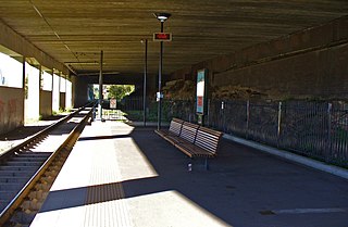
Strathfield railway station is a heritage-listed railway station located on the Main Suburban line in the Sydney suburb of Strathfield in the Municipality of Strathfield local government area of New South Wales, Australia. The station is served by Sydney Trains T1 North Shore & Western Line, T9 Northern Line and T2 Inner West & Leppington Line suburban services as well as NSW TrainLink Intercity and regional services. The station is located on the Main Northern and Main Western railway lines, forming a major junction for regional and suburban rail services. The station and associated infrastructure was added to the New South Wales State Heritage Register on 2 April 1999.

<span class="mw-page-title-main">City West Link</span> Road in Sydney, Australia

City West Link is a 5.0-kilometre (3.1 mi) link road connecting Parramatta Road and the Western Distributor through the Inner West suburbs of Sydney, New South Wales, Australia. It will be bypassed by the WestConnex project upon its completion in late 2023. This name covers a few consecutive roads and is widely known to most drivers, but the entire allocation is also known – and signposted – by the names of its constituent parts: Wattle Street, Dobroyd Parade, City West Link proper and The Cresent.

<span class="mw-page-title-main">Pennant Hills Road</span> Highway in Sydney, Australia

Pennant Hills Road is a 16.1-kilometre-long (10.0 mi) arterial road located in Sydney, New South Wales, Australia. The road links the suburb of Wahroonga in the northeast, to the major central business district of Parramatta in the southwest. Apart from a small section at its southwestern end, it is a constituent part of Cumberland Highway, and is designated part of route A28.

<span class="mw-page-title-main">M4 Motorway (Sydney)</span> Motorway in Sydney

The M4 Motorway is a 52.6-kilometre (32.7 mi) partially tolled dual carriageway motorway in Sydney, New South Wales that is designated the M4 route marker. The M4 designation is part of the wider A4 and M4 route designation, the M4 runs parallel/below ground to the Great Western Highway and Parramatta Road (A44).

<span class="mw-page-title-main">M5 Motorway (Sydney)</span> Motorway in Sydney, Australia

The M5 Motorway is a 29-kilometre (18 mi) motorway located in Sydney, New South Wales that is part of the Sydney Orbital Network.

<span class="mw-page-title-main">Western Distributor (Sydney)</span>

Western Distributor is a 4.3-kilometre-long (2.7 mi) grade-separated motorway that is primarily elevated for the majority of its route on the western fringe of the Sydney central business district in New South Wales, Australia. It links the southern end of Bradfield Highway at the Sydney Harbour Bridge to Victoria Road in Rozelle, at its western terminus near White Bay. It is a constituent part of the A4 route.

Sydney Bypass refers to a number of roads, existing and proposed, that motorists can use to avoid the congested approaches to the Sydney central business district (CBD). The main bypasses are:

WestConnex is a 33-kilometre (21 mi) predominantly underground motorway scheme in Sydney, New South Wales, Australia. As of 2023, it is partially completed and partially still under construction. A joint project of the New South Wales and Federal governments, the motorway scheme is creating around 26 kilometres (16 mi) of new tunnels between Homebush and Kingsgrove, passing underneath Inner West suburbs including Haberfield and St Peters. The first of the tunnels, the M4 East, opened to traffic in July 2019. The second of the tunnels, the M8 Motorway, opened to traffic a year later in July 2020. The third of the tunnels which extend the M4 and M8 opened to traffic in January 2023, and the rest of the tunnels are expected to open to traffic in late 2023.

References

  1. "City's main artery a desolate wasteland". The Daily Telegraph. 18 April 2011. Retrieved 14 January 2015.
  2. "AV Union". Time Out Sydney, Nicholas Adams. 16 October 2012. Archived from the original on 15 January 2015. Retrieved 14 January 2015.
  3. "Renew project targets Forum". Alt Media, Mason McCann. 26 September 2013. Retrieved 14 January 2015.
  4. "PARRAMATTA ROAD – History". Archived from the original on 15 January 2015.
  5. Broomham, Rosemary (2001), Vital connections: a history of NSW roads from 1788, Hale & Iremonger in association with the Roads & Traffic Authority, p. 25, ISBN   978-0-86806-703-2
  6. "Sandstone Kerb - Parramatta Road". State Heritage Register. Office of Environment & Heritage, Government of New South Wales. 2005. Retrieved 7 October 2013.
  7. Francis Peron, 'Account of Port Jackson and Sydney Town, New South Wales', translation quoted in The literary panorama, vol 10, Charles Taylor, London, 1809, col 921
  8. The Roadmakers: A History of Main Roads in New South Wales, Department of Main Roads, Sydney, 1976, p 47
  9. "WestConnex". NSW Government. Archived from the original on 10 July 2019. Retrieved 10 July 2019.
  10. "New M4 tunnels to open this weekend". WestConnex. 10 July 2019. Retrieved 10 July 2019.
  11. "CAN PARRAMATTA RD ROCK ONCE MORE?". Ciao Magazine. 12 July 2013. Retrieved 14 January 2015.
  12. "200-year dream for renewal and free flow for 'varicose vein'". Sydney Morning Herald. 5 October 2012. Retrieved 16 January 2015.
  13. "Developers won't save Parramatta Road alone". Sydney Morning Herald. 21 June 2012. Retrieved 16 January 2015.
  14. "isbn:9052010366 – Google Search".
  15. "A chance to get Parramatta Road right". Sydney Morning Herald. 31 October 2014. Retrieved 16 January 2015.
  16. Why derelict buildings worth millions are being left behind in a region desperate for places to live by David Barwell (The Daily Telegraph)
  17. 1 2 'The shops have closed': Parramatta Road 'a lost cause', retailer says by Garry Maddox (Sydney Morning Herald)
  18. "Parramatta Road Urban Transformation Strategy 2016". Landcom. 19 February 2020. Retrieved 11 March 2021.
  19. "Parramatta Road Corridor Urban Transformation Strategy" (PDF).
  20. "Parramatta Road Urban Renewal - Inner West Council". www.innerwest.nsw.gov.au. Retrieved 11 March 2021.
  21. "National Route 32". OZROADS: The Australian Roads Website. 2013. Retrieved 1 June 2013.[ self-published source ]
  22. "National Routes". OZROADS: The Australian Roads Website. 2013. Retrieved 1 June 2013.[ self-published source ]
  23. "Metroad 4". OZROADS: The Australian Roads Website. 2013. Retrieved 1 June 2013.[ self-published source ]
  24. "Metroad 5". OZROADS: The Australian Roads Website. 2013. Retrieved 1 June 2013.[ self-published source ]

33°52′05″S151°05′57″E / 33.86814°S 151.09909°E / -33.86814; 151.09909