Iron Cove Creek

Last updated

Iron Cove
Iron Cove Creek empties into Iron Cove, Five Dock.jpg
Iron Cove Creek looking towards Iron Cove.
Location
Country Australia
State New South Wales
Municipality Sydney
Physical characteristics
Source Ashfield Park
  location Ashfield
  coordinates 33°53′20″S151°7′30″E / 33.88889°S 151.12500°E / -33.88889; 151.12500
Mouth Parramatta River
  location
Iron Cove
  coordinates
33°52′13.4862″S151°8′31.02″E / 33.870412833°S 151.1419500°E / -33.870412833; 151.1419500 Coordinates: 33°52′13.4862″S151°8′31.02″E / 33.870412833°S 151.1419500°E / -33.870412833; 151.1419500
Basin features
River system Parramatta River

Iron Cove Creek (also known as Dobroyd Stormwater Channel), a southern tributary of the Parramatta River, is an urban stream west of Sydney Harbour, located in the inner-western Sydney suburbs of Croydon, Ashfield, Haberfield and Five Dock in New South Wales, Australia.

Contents

Iron Cove Creek traverses mostly through residential areas and parkland, making a 2 kilometres (1.2 mi) journey from where it surfaces in Croydon to where it empties into Iron Cove, which is a bay of the Parramatta River, at Five Dock. It also forms much of the border between Croydon and Ashfield upstream from Parramatta Road. Once a natural watercourse abound with native vegetation and wildlife, Iron Cove Creek was transformed in the late 19th century into a stormwater channel that drains a fairly large catchment area in Sydney's inner-western suburbs.

History

Iron Cove Creek flowing swiftly after a thunderstorm. Looking upstream from the Church Street bridge, Croydon, NSW Iron Cove Creek looking upstream after rain.jpg
Iron Cove Creek flowing swiftly after a thunderstorm. Looking upstream from the Church Street bridge, Croydon, NSW

In the 1860s Iron Cove Creek was a freely flowing waterway which in places broadened into ponds that made excellent and picturesque swimming holes. Water birds and snakes were abundant in this area and these, like the possums and gliders that inhabited the treetops, often fell victim to the predations [ citation needed ] of children with improvised bows and arrows and slingshots and their elders armed with more sophisticated weapons [ ambiguous ].

During the 1890s the character and appearance of Iron Cove Creek was dramatically altered. As early as 1880 Iron Cove Creek was perceived to present hazards both to the health and convenience of the local community; it tended to flood in heavy rain and to become stagnant during dry weather and, with the sanitary conditions that then prevailed, was a source of typhoid fever. Plans were made to concrete its banks, but major work did not commence until 1891. The construction of the banks was carried out by the Department of Public Works and was supervised by a local resident, William Best Chessell. It took five years and had a profound effect on the appearance and future development of Croydon. In his book Between Two Highways: the story of early Croydon, Eric Dunlop points out that as a result of the construction of canals and tunnels:[ citation needed ]

the waters now drained away quickly, the swamps and pools disappeared, and as the banks of the main stream were filled in and leveled to the edges of the canal its wooded foreshores vanished and more land became available for settlement.

Present course

A rapid Iron Cove Creek flowing downstream from the John St bridge after a thunderstorm, Ashfield, NSW. Iron Cove Creek looking downstream from John St.jpg
A rapid Iron Cove Creek flowing downstream from the John St bridge after a thunderstorm, Ashfield, NSW.

Iron Cove Creek begins as a tiny trickle in a narrow channel near Norton Street in Croydon, where it appears as a stormwater tunnel finally exiting into daylight. From here, it makes its way through a cement cutting only a few metres wide with high concrete walls on either side and passes under the Main Suburban railway line. From here until Parramatta Road it remains just a small trickle during dry weather. The canal is bounded by the fences of commercial and residential properties as well as a barbed wire fence along Etonville Parade, and is for the most part hidden from the public eye.

The creek's character does not change until it reaches the John Street bridge where the concreted channel widens significantly and the height of the banks drops about threefold. From John Street to West Street, Iron Cove Creek is flanked by a wide grass verge covered with various types of vegetation leaving potential for a recreational walking/cycling path beside the creek. There is also ample space for bush regeneration to take place by the planting of indigenous species. About 100 metres (330 ft) downstream from West Street is the Parramatta Road bridge, which marks the approximate tidal limit of the creek. Adjacent to the creek on Parramatta Road are popular fast-food restaurants, a council depot and a service station. After flowing under the Parramatta Road bridge, Iron Cove Creek finally enters public parkland and becomes a broad channel probably similar to the width of the original channel. On the right is parkland and running parallel to the creek on the left bank of is Henley Marine Drive. Iron Cove Creek then passes beneath Ramsay Street, widens further, and proceeds through parkland including Timbrell Park.

The creek is very tidal here and the water level difference between low and high tide is significant. The tidal limit of Dobroyd Canal is located 100 metres (330 ft) upstream of Parramatta Road. [1] Mullet may also be seen in the lower reaches of Iron Cove Creek below Parramatta Road at high tide.

The creek empties into Iron Cove as a broad canal at the intersection of Timbrell Drive and Dobroyd Parade at Five Dock, where there is a floating boom across the creek that is designed to stop pollution entering Port Jackson.

Between Parramatta Road and Iron Cove, Iron Cove Creek forms part of the border between the federal electoral divisions of Reid and Grayndler following a 2009 redistribution.[ citation needed ]

Church Street bridge

The Church Street bridge spans Iron Cove Creek on the border of the inner-western suburbs of Croydon and Ashfield. The bridge is built of sandstone, brick, and steel. The course of Church Street was originally defined by the track used by Burwood residents to attend St John's Ashfield, who crossed the Creek at a conveniently-located large fallen tree. [2]

Pollution

The lower reaches of Iron Cove Creek beside Dobroyd Pde, Five Dock at low tide. Iron Cove Creek at Timbrell Park, Five Dock.jpg
The lower reaches of Iron Cove Creek beside Dobroyd Pde, Five Dock at low tide.

Pollution entering Iron Cove from Iron Cove Creek poses as a serious environmental problem as materials such as heavy metals, asphalt, road dust and various nutrients flow into the creek during rainfall. This problem is enhanced by the fact popular fast-food restaurants and a service station are located adjacent to Iron Cove Creek on Parramatta Road. Also, the concrete lining of the creek prevents the growth of natural vegetation such as mangroves which assist in maintaining water quality.

Iron Cove Creek supplies water and sediment enriched in copper, lead and zinc to the Iron Cove under low flow conditions and is a major source of contaminants. Increasing salinity in the lower sections of Iron Cove Creek largely controls partitioning between the particulate and dissolved phases of copper, lead and zinc. Contaminant loading to Iron Cove may be contingent on extended periods of low flow rather than high flow events during which contaminated material is rapidly exported from the estuary in a discrete surface layer. This unusual characteristic offers attractive possibilities for remediation of stormwater entering Port Jackson.

Related Research Articles

River Camel River in the United Kingdom

The River Camel is a river in Cornwall, England, United Kingdom. It rises on the edge of Bodmin Moor and with its tributaries its catchment area covers much of North Cornwall. The river flows into the eastern Celtic Sea between Stepper Point and Pentire Point having covered about 30 miles, making it the second longest river wholly in Cornwall. The river is tidal upstream to Egloshayle and is popular for sailing, birdwatching and fishing. The name Camel comes from the Cornish language for 'the crooked one', a reference to its winding course. Historically the river was divided into three named stretches. Heyl was the name for the estuary up to Egloshayle, the River Allen was the stretch between Egloshayle and Trecarne, whilst the Camel was reserved for the stretch of river between its source and Trecarne.

Parramatta River River in Australia

The Parramatta River is an intermediate tide-dominated, drowned valley estuary located in Sydney, New South Wales, Australia. With an average depth of 5.1 metres (17 ft), the Parramatta River is the main tributary of Sydney Harbour, a branch of Port Jackson. Secondary tributaries include the smaller Lane Cove and Duck rivers.

Lane Cove River

The Lane Cove River, a northern tributary of the Parramatta River, is a tide-dominated, drowned valley estuary west of Sydney Harbour, located in Sydney, New South Wales, Australia. The river is a tributary of the Parramatta River, winding through a bushland valley. It joins Parramatta River at Greenwich and Woolwich, where together they form an arm of Sydney Harbour, and serves a border along with Middle Harbour separating Sydney's North Shore.

Inner West Region in New South Wales, Australia

The Inner West of Sydney is an area directly west of the Sydney central business district, New South Wales, Australia. The suburbs that make up the Inner West are predominantly located along the southern shore of Port Jackson, stretching south to the shores of the Cooks River. The western boundary of the Inner West is approximately the A3 arterial road, which divides the Inner West from the Greater Western Sydney region. The Inner West is much larger than the Inner West Council local government area. The Inner West roughly corresponds with the Parish of Petersham and Parish of Concord, two cadastral divisions used for land titles.

Haberfield, New South Wales Suburb of Sydney, New South Wales, Australia

Haberfield is a suburb in the Inner West of Sydney, in the state of New South Wales, Australia. Haberfield is located 6.5 kilometres west of the Sydney central business district in the local government area of the Inner West Council.

Croydon, New South Wales Suburb of Sydney, New South Wales, Australia

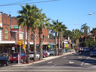
Croydon is a suburb in the Inner West of Sydney, in the state of New South Wales, Australia. It is located 9 kilometres (5.6 mi) west of the Sydney central business district. Croydon is split between the two local government areas of Municipality of Burwood and the Inner West Council.

Tank Stream

The Tank Stream is a heritage-listed former fresh water tributary of Sydney Cove and now tunnel and watercourse located in the Sydney central business district, in the City of Sydney local government area of New South Wales, Australia. The Tank Stream was the fresh water supply for the fledgling colony of New South Wales in the late 18th century. Today it is little more than a storm water drain. It originated from a swamp to the west of present-day Hyde Park and at high tide entered Sydney Cove at what is now the intersection of Bridge and Pitt Streets in the Sydney central business district. The catchment was 65 hectares, corresponding roughly the size of the Sydney central business district. It was added to the New South Wales State Heritage Register on 2 April 1999.

Five Dock, New South Wales Suburb of Sydney, New South Wales, Australia

Five Dock is a suburb in the Inner West of Sydney, in the state of New South Wales, Australia. Five Dock is located 10 kilometres west of the Sydney central business district, in the local government area of the City of Canada Bay.

Mullum Mullum Creek

Mullum Mullum Creek is a creek in the outer eastern suburbs of Melbourne, Victoria, Australia. It is the main watercourse of the Mullum Mullum Valley, a tributary of the Yarra River and Yarra Valley. For tens of thousands of years it was used as a food and tool source sustainably by the Wurundjeri people, Indigenous Australians of the Kulin nation, who spoke variations of the Woiwurrung language group.

City West Link

City West Link is a link road in Sydney, Australia. It makes up a section of the A4 between Leichhardt, Haberfield and Five Dock. As such, it provides an alternative route to Parramatta Road into Sydney's CBD from the Inner-West. It is part of the A4 corridor. It will be completely bypassed by the WestConnex project when completed in 2023.

Iron Cove Bay on the Parramatta River in Australia

Iron Cove is a bay on the Parramatta River, in the inner-west of Sydney, in the state of New South Wales, Australia. It is approximately 5 kilometres (3.1 mi) due west of Sydney's central business district. It is surrounded by the suburbs of Birchgrove, Balmain, Rozelle, Lilyfield, Haberfield, Five Dock, Rodd Point, Russell Lea and Drummoyne. The bay extends from Longnose Point to the south-west and is fed by the Hawthorne Canal and the Iron Cove Creek.

Hawthorne Canal

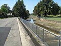
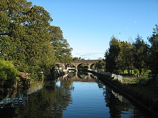
The Hawthorne Canal, a southern tributary of the Parramatta River, is a heritage–listed artificial waterway located in the western reaches of Sydney Harbour, in the inner–western Sydney suburbs of Lewisham, Summer Hill, Haberfield, and Leichhardt in New South Wales, Australia.

Elizabeth Underwood Australian pioneering land owner (1794–1858)

Elizabeth Underwood in Norfolk Island, New South Wales, Australia, was a pioneering Australian land owner who founded the village of Ashfield, New South Wales.

The Bay Run

The Bay Run is a 7 kilometre-long pedestrian and cycling circuit around Iron Cove in the suburbs of Rozelle, Lilyfield, Haberfield, Five Dock and Drummoyne in the inner-west of Sydney, New South Wales, Australia. The Bay Run provides excellent views of Iron Cove for its entire course as it constantly hugs the shoreline. The Bay Run is popular with joggers, walkers, roller skaters and cyclists who enjoy the pleasant waterside scenery while exercising. The Bay Run plays host to the annual Bay Run fun run, a community event that brings people together in the name of health, fun and exercise.

Haslams Creek

Haslams Creek, a southern tributary of the Parramatta River, is a creek west of Sydney Harbour, located in Sydney, Australia. It flows through Sydney Olympic Park and joins Parramatta River at Homebush Bay.

Johnstons Creek (New South Wales)

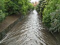
Johnstons Creek, formerly Johnston's Creek, is an urban gully, located in Sydney, Australia and situated in the Leichhardt local government area. The creek flows from Petersham, past Annandale, Camperdown, Forest Lodge and Harold Park, before spilling into Rozelle Bay, within Sydney Harbour.

Duck River (New South Wales)

The Duck River is a perennial stream and southern tributary of the Parramatta River, in Sydney, New South Wales, Australia.

Archer Creek, a northern tributary of the Parramatta River, is a creek west of Sydney Harbour, located in Sydney, New South Wales, Australia. It joins Parramatta River at Meadowbank Park, Meadowbank.

Yasmar

Yasmar is a heritage-listed house at 185 Parramatta Road, Haberfield, Inner West Council, Sydney, New South Wales, Australia. It has variously served as a private home, Sunday school, children's court and juvenile remand and detention centre, and is now used by community groups and as a correctional services training facility. It was designed by John Bibb and built from 1856 to 1858. The surrounding site has also been known as Yasmar Hostel, Yasmar Detention Centre, Yasmar Child Welfare Home, Ashfield Remand Home, Yasmar Shelter and the Yasmar Juvenile Justice Centre. The property is owned by Land and Property Management Authority (LPMA). It was added to the New South Wales State Heritage Register on 18 February 2000.

Lewisham Sewage Aqueduct

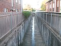
Lewisham Sewage Aqueduct is a heritage-listed sewage aqueduct in Gadigal Reserve, adjacent to 5 Grosvenor Crescent, Summer Hill, Inner West Council, Sydney, New South Wales, Australia. It was designed by Sewerage Construction Branch and Department of Public Works and built in 1900. The property is owned by Sydney Water. It was added to the New South Wales State Heritage Register on 18 November 1999.

References

Citations

  1. "Parramatta River Estuary Data Compilation and Review Study" (PDF). Parramatta River Estuary Management Committee. July 2008. p. 16. Retrieved 6 September 2012.
  2. Coupe, Sheena and Robert (1988). Speed The Plough, Ashfield 1788–1988. The Council of the Municipality of Ashfield. p. 49. ISBN   0-9595234-1-3.

Sources