Woolwich, New South Wales

Last updated

Woolwich
Sydney,  New South Wales
Woolwich Lookout.JPG
Woolwich Lookout
Woolwich, New South Wales
Woolwich
Population814 (2016 census) [1]
Postcode(s) 2110
Location11 km (7 mi) west of Sydney CBD
LGA(s) Municipality of Hunter's Hill
State electorate(s) Lane Cove
Federal division(s) North Sydney
Suburbs around Woolwich:
Longueville Greenwich Northwood
Hunters Hill Woolwich Greenwich
Drummoyne Cockatoo Island Birchgrove

Woolwich is a suburb on the Lower North Shore of Sydney, in the state of New South Wales, Australia. Woolwich is located 11 kilometres north-west of the Sydney central business district, in the local government area of the Municipality of Hunter's Hill. Woolwich sits on the peninsula between the Lane Cove River and the Parramatta River, jutting out from Hunters Hill.

Contents

History

The suburb's name is derived from its namesake Woolwich, by the banks of the Thames in London. Parramatta River had been known as the 'Thames of the Antipodes' and other nearby suburbs were also named after Thames localities of Greenwich, Putney and Henley. [2]

The area's Aboriginal name is 'Mookaboola' or 'Moocooboola', which means meeting of waters. An early settler was John Clarke, who bought land here in 1834 and is responsible for naming Clarke's Point. Samuel Onion was another early land owner with an ironmongery business and he gave the suburb its first name 'Onion Point' in 1835.

The world's first, union-led green ban was placed on the suburb. Jack Mundey and his followers in the Builder's Labourers Federation did not support the destruction of local habitat. They eventually won their battle and 'Kelly's Bush' remains today.

61 properties in Woolwich are listed on the NSW State Heritage Register, including the Woolwich Pier Hotel and the Woolwich Wharf. [3] There are also notable heritage items of local significance dotted across the peninsula, including St John’s Anglican Church built in 1908. It has a simple gabled form from the Victorian Gothic revival style. The church became Hunter’s Hill Theatre [4] in more recent years and was sold in 2012 to become a residential house. More recently, the Church underwent a significant renovation by Arc Architects and Interior Architecture by Michiru Higginbotham completed in 2020. [5] [6]

Clarks Point Reserve, Woolwich, New South Wales Clarks Point Reserve, Woolwich, New South Wales.jpg
Clarks Point Reserve, Woolwich, New South Wales

Population

Demographics

In the 2016 Australian Bureau of Statistics Census of Population and Housing, the population of Woolwich stood at 814 people, 53.1% female and 46.9% male, and with a Median age of 51 years. 72.5% of people were born in Australia and 78.6% of people only spoke English at home. The most common responses for religion were Catholic 32.1%, No Religion 28.6% and Anglican 19.8%. [1]

Woolwich's median weekly household income was $3,211, compared with $1,438 in Australia. According to the Australian Taxation Office statistics for the financial year of 2016–2017, the postcode of 2110 (Hunters Hill & Woolwich) had an average taxable income of $156,069 making it the 10th wealthiest suburb in Australia. [7] The most common response for occupations was Professionals with 37.7% of all responses. 76.1% of the suburb's occupied private dwellings were family households. [1]

Politics

State Elections [8]
Liberal 63.5%
Labor 16.5%
Greens 12.1%
Democrats 6.5%
Christian Democrats 0.9%
Unity Party 0.4%
Federal Elections [9]
Liberal64.86%
Labor28.17%
Greens6.12%
Christian Democrats 0.57%
Climate Change 0.28%
Independent0.00%
Family First 0.00%
Citizens Electoral Council 0.00%

Woolwich is in the federal electoral division of North Sydney. This seat was won by Joe Hockey, the current Treasurer of Australia at the 1996 federal election and retained most recently in the 2013 Australian federal election. [10] North Sydney is one of only two original divisions in New South Wales, along with Wentworth, which have never been held by the Australian Labor Party (ALP).

For NSW state elections, Woolwich is in the Electoral district of Lane Cove. As of 2003 this seat is held by Liberal MP Anthony Roberts, who was last re-elected in the 2007 state election except for the March 2011 NSW State election. [11]

Schools

Marist Sisters' College, Woolwich and Woolwich Public School.

Related Research Articles

<span class="mw-page-title-main">Lane Cove River</span> River in Sydney, Australia

The Lane Cove River, a northern tributary of the Parramatta River, is a tide-dominated, drowned valley estuary west of Sydney Harbour, located in Sydney, New South Wales, Australia. The river is a tributary of the Parramatta River, winding through a bushland valley. It joins Parramatta River at Greenwich and Woolwich, where together they form an arm of Sydney Harbour, and serves as a border along with Middle Harbour separating Sydney's North Shore.

<span class="mw-page-title-main">Greenwich, New South Wales</span> Suburb of Sydney, New South Wales

Greenwich is a suburb on the Lower North Shore of Sydney, in the state of New South Wales, Australia. Greenwich is located 7 kilometres (4 mi) north-west of the Sydney central business district, in the local government area of the Municipality of Lane Cove.

<span class="mw-page-title-main">Hunters Hill, New South Wales</span> Suburb of Sydney, New South Wales, Australia

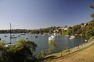
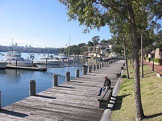
Hunters Hill is a suburb of the lower north shore of Sydney, in the state of New South Wales, Australia. Hunters Hill is located 9 kilometres (5.6 mi) north-west of the Sydney central business district and is the administrative centre for the local government area of the Municipality of Hunter's Hill.

<span class="mw-page-title-main">Summer Hill, New South Wales</span> Suburb of Sydney, New South Wales, Australia

Summer Hill is a suburb of Sydney, in the state of New South Wales, Australia. Summer Hill is located 7 kilometres west of the Sydney central business district, in the local government area of the Inner West Council.

<span class="mw-page-title-main">Longueville, New South Wales</span> Suburb of Sydney, New South Wales, Australia

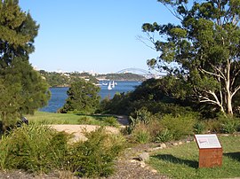
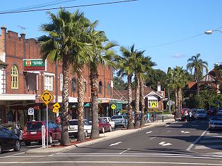
Longueville is an affluent harbourside suburb on the Lower North Shore of Sydney, New South Wales, 8 kilometres north-west of the Sydney central business district, in the local government area of the Municipality of Lane Cove.

Dundas is a suburb of Sydney, New South Wales, Australia. Dundas is located 21 kilometres north-west of the Sydney central business district, in the local government area of the City of Parramatta, and the electoral division of Bennelong. Dundas is a leafy green suburb, notably due to its centrepiece The Ponds Walk, which follows the Ponds Subiaco Creek. Dundas is part of the Northern Sydney and Greater Western Sydney regions.

<span class="mw-page-title-main">Croydon, New South Wales</span> Suburb of Sydney, New South Wales, Australia

Croydon is a suburb in the Inner West of Sydney, in the state of New South Wales, Australia. It is located 9 kilometres (5.6 mi) west of the Sydney central business district. Croydon is split between the two local government areas of Municipality of Burwood and the Inner West Council.

<span class="mw-page-title-main">Gladesville</span> Suburb of Sydney, New South Wales, Australia

Gladesville is a suburb in the Lower North Shore of Sydney, in the state of New South Wales, Australia. Gladesville is located 10 kilometres north-west of the Sydney central business district, in the local government area of the City of Ryde and the Municipality of Hunter's Hill. Gladesville is part of the federal electorates of North Sydney and Bennelong.

<span class="mw-page-title-main">Mortlake, New South Wales</span> Suburb of Sydney, New South Wales, Australia

Mortlake is a suburb in the Inner West of Sydney, in the state of New South Wales, Australia. It is 10 kilometres west of the Sydney central business district, in the local government area of the City of Canada Bay.

<span class="mw-page-title-main">Meadowbank, New South Wales</span> Suburb of Sydney, New South Wales, Australia

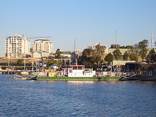
Meadowbank is a suburb of Sydney, New South Wales, Australia, 15 kilometres north west of the Sydney central business district, in the local government area of the City of Ryde and part of the Northern Sydney region. Meadowbank sits in a valley on the northern bank of the Parramatta River.

<span class="mw-page-title-main">Linley Point, New South Wales</span> Suburb of Sydney, New South Wales, Australia

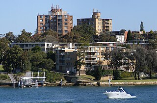
Linley Point is a small peninsular suburb located on the Lower North Shore of Sydney, in the local government area of the Municipality of Lane Cove, in the state of New South Wales, Australia. It is approximately 10 kilometres north-west of the Sydney central business district by car.

<span class="mw-page-title-main">Birchgrove, New South Wales</span> Suburb of Sydney, New South Wales, Australia

Birchgrove is a suburb in the Inner West of Sydney, in the state of New South Wales, Australia. Birchgrove is located five kilometres west of the Sydney central business district, in the local government area of the Inner West Council.

<span class="mw-page-title-main">Camellia, New South Wales</span> Suburb of Sydney, New South Wales, Australia

Camellia is a suburb of Sydney, in the state of New South Wales, Australia. Primarily industrial with no residential population, environmental remediation commenced in late 2015, with the suburb ear-marked as a major centre for future high density living.

<span class="mw-page-title-main">Chiswick, New South Wales</span> Suburb of Sydney, New South Wales, Australia

Chiswick is a suburb in the Inner West of Sydney, in the state of New South Wales, Australia. It is located 9 kilometres west of the Sydney central business district in the local government area of the City of Canada Bay. Chiswick sits on the peninsula between Abbotsford Bay and Five Dock Bay, on the Parramatta River. It is surrounded by the suburbs of Abbotsford, Russell Lea and Drummoyne.

<span class="mw-page-title-main">Ermington, New South Wales</span> Suburb of Sydney, New South Wales, Australia

Ermington is a suburb of Sydney, New South Wales, Australia. Ermington is located 19 kilometres West of the Sydney central business district, in the local government area of the City of Parramatta. Ermington lies on the northern bank of the Parramatta River.

<span class="mw-page-title-main">Henley, New South Wales</span> Suburb of Sydney, New South Wales, Australia

Henley is a suburb on the Lower North Shore of Sydney, in the state of New South Wales, Australia. Henley is located 9 kilometres west of the Sydney central business district, in the local government area of the Municipality of Hunter's Hill. Henley sits on the northern side of the Parramatta River.

<span class="mw-page-title-main">Electoral district of Lane Cove</span>

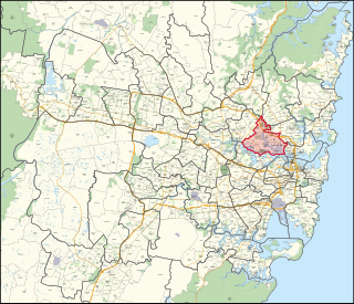
Lane Cove is an electoral district of the Legislative Assembly in the Australian state of New South Wales. It is represented by Anthony Roberts of the Liberal Party. The electoral district of Lane Cove encompasses the suburbs and localities of Artarmon, Chatswood West, East Ryde, Gladesville, Gore Hill, Greenwich, Henley, Hunters Hill, Huntleys Point, Lane Cove, Linley Point, Longueville, Macquarie Park, Monash Park, North Ryde, Northwood, Putney, Riverview, Ryde, St Leonards, Tambourine Bay and Woolwich.

<span class="mw-page-title-main">Parramatta River ferry services</span>

Parramatta River ferry services connect suburbs along the Parramatta River in Sydney with Circular Quay by commuter ferry. The services are numbered F3 and form part of the Sydney Ferries network.

<span class="mw-page-title-main">Northern Sydney</span> Region of Sydney in New South Wales, Australia

Northern Sydney is a large metropolitan area in Greater Sydney, New South Wales, Australia on the north shore of Sydney Harbour and Parramatta River. The region embraces suburbs in Sydney's north-east, north and inner north west. Northern Sydney is divided into distinctive regions such as the North Shore, Northern Beaches and Forest District.

<span class="mw-page-title-main">Greenwich Point ferry wharf</span>

Greenwich Point ferry wharf is located on Sydney Harbour serving the Sydney suburb of Greenwich. It served by Sydney Ferries Cockatoo Island services operating between Circular Quay and Cockatoo Island. The single wharf is served by First Fleet and Emerald class ferries. It is also served by limited school term services by Captain Cook Cruises services to Hunters Hill.

References

  1. 1 2 3 Australian Bureau of Statistics (27 June 2017). "Woolwich (State Suburb)". 2016 Census QuickStats. Retrieved 18 November 2017. OOjs UI icon edit-ltr-progressive.svg
  2. The Book of Sydney Suburbs, Compiled by Frances Pollon, Angus & Robertson Publishers, 1990, Published in Australia ISBN   0-207-14495-8, page 276
  3. "Search the State Heritage Inventory". Heritage NSW. 22 October 2019. Retrieved 4 May 2021.
  4. "ABOUT US". HUNTERS HILL THEATRE. Retrieved 30 November 2023.
  5. Heritage Impact Statement for re-use of St John's Church Woolwich prepared by Bruce Lay of Heritage Solutions. July 2017.
  6. "The Church Woolwich Sydney". Michiru Higginbotham - Sydney Residential Architecture & Interior Design. Retrieved 30 November 2023.
  7. "Australia's richest and poorest postcodes revealed". ABC News. 28 March 2019.
  8. "State Electoral District – Lane Cove Results 2007". State Elections. Electoral Commission NSW. 2007. Retrieved 28 December 2007. Percentages calculated using combined results for "Woolwich" polling booths, and only counting formal votes.
  9. "Polling Place – Woolwich". House of Representatives – Election 2007. Australian Electoral Commission. 2007. Retrieved 28 December 2007.
  10. "Electoral Division of North Sydney (NSW) The Hon Joe Hockey MP". Members. Commonwealth of Australia. 14 March 2008. Retrieved 16 March 2008.
  11. "Mr Anthony John ROBERTS, MP". Legislative Assembly. Parliament of New South Wales. 2007. Archived from the original on 29 September 2007. Retrieved 19 December 2007.

33°50′24″S151°10′16″E / 33.840°S 151.171°E / -33.840; 151.171