Johnstons Creek (New South Wales)

Last updated

Johnstons Creek
Johnston's Creek
Johnstons Creek, Glebe NSW.JPG
Johnstons Creek from the footbridge between Federal and Bicentennial Parks.
EtymologyIn honour of Lieutenant-Colonel George Johnston [1]
Location
Country Australia
State New South Wales
Region Sydney basin (IBRA), Sydney, Inner West
Council Inner West, Sydney
Physical characteristics
Source 
  location Petersham
Mouth Johnstons Bay
  location
Rozelle Bay
Basin features
River system Port Jackson/Sydney Harbour
Tributaries 
  right Orphan School Creek

Johnstons Creek, formerly Johnston's Creek, is an urban gully, [2] located in Sydney, Australia and situated in the Inner West and Sydney local government areas. The creek flows from Petersham, past Annandale, Camperdown, Forest Lodge and Harold Park, before spilling into Rozelle Bay, within Sydney Harbour.

Contents

Course and features

Originally a natural watercourse, Johnston's Creek was converted into a brick and concrete channel in the 1890s in order to improve sanitation in Sydney[ citation needed ]. The creek rises in Petersham and initially marked the eastern boundary of the land granted to Lieutenant-Colonel George Johnston [1] in the 1790s, which he named Annandale. The Annandale Estate was subdivided in the latter part of the 19th Century into what is now the suburbs of Stanmore and Annandale. The channel now forms a boundary of Annandale, Forest Lodge, Camperdown and Stanmore.[ citation needed ]

Johnstons Creek has one minor tributary, Orphan School Creek, an urban canal that joins Johnstons Creek at Forest Lodge.[ citation needed ]

Urban structures

Johnstons Creek is crossed by the Annandale Bridge on Parramatta Road, and road bridges at Booth Street and The Crescent. The heritage-listed Allan Truss Bridge, formerly the Federal Road Bridge, crosses Johnstons Creek near its mouth, connecting Annandale and Glebe. The bridge was decommissioned for road usage and converted as a footbridge in 2000. [3] A small pedestrian and road bridge crosses the canal at Harold Park,[ citation needed ] and a former tram bridge provides a direct route from Minogue Crescent to Hogan and Spindler Park. The Bowstring Bridge, a footbridge, is an early example of reinforced concrete bowstring arch bridges built in Australia, located on Minogue Crescent, Forest Lodge. [4]

A heavy rail viaduct, now used for the Inner West Light Rail, crosses the creek between Jubilee Park and Federal Park, west of Glebe.

Completed in 1898, the Johnston's Creek Sewer Aqueduct connects Sydney's western suburbs to the Northern Main Sewer extension of the Bondi Ocean Outfall Sewer, managed by Sydney Water. The Johnston's and White's Creek Aqueducts, both listed on the Register of the National Estate, were the first reinforced concrete structures in Australia. [5]

A salt marsh wetland was constructed in 2001 to filter storm water before it enters Sydney Harbour via Johnston's Creek.[ citation needed ]

In 2020 Sydney Water started a major project to naturalise the creek from The Crescent to the mouth at Rozelle Bay. [6]

Marine life

In September 2009 a bull shark believed to be 1.8 metres (5 ft 11 in) long was sighted in Johnstons Creek. The shark was last seen swimming along the Glebe foreshore in the direction of the Anzac Bridge. [7]

See also

Related Research Articles

<span class="mw-page-title-main">Port Jackson</span> Body of water in Sydney, Australia

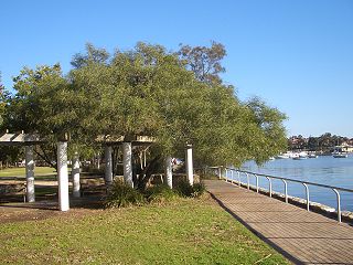
Port Jackson, consisting of the waters of Sydney Harbour, Middle Harbour, North Harbour and the Lane Cove and Parramatta Rivers, is the ria or natural harbour of Sydney, New South Wales, Australia. The harbour is an inlet of the Tasman Sea. It is the location of the Sydney Opera House and Sydney Harbour Bridge. The location of the first European settlement and colony on the Australian mainland, Port Jackson has continued to play a key role in the history and development of Sydney.

<span class="mw-page-title-main">Leichhardt, New South Wales</span> Suburb of Sydney, New South Wales, Australia

Leichhardt is a suburb in the Inner West of Sydney, in the state of New South Wales, Australia. Leichhardt is located 5 kilometres west of the Sydney central business district (CBD) and is the administrative centre for the local government area (LGA) of the Inner West Council. The suburb is bordered by Haberfield to the west, Annandale to the east, Lilyfield to the north and Petersham, Lewisham and Stanmore to the south.

<span class="mw-page-title-main">Glebe, New South Wales</span> Suburb of Sydney, New South Wales, Australia

Glebe is an inner-western suburb of Sydney in New South Wales. Glebe is located 3 kilometres (1.9 mi) southwest of the Sydney central business district and is part of the local government area of the City of Sydney, in the Inner West region.

<span class="mw-page-title-main">Lilyfield, New South Wales</span> Suburb of Sydney, New South Wales, Australia

Lilyfield is a suburb in the Inner West of Sydney, in the state of New South Wales, Australia. Lilyfield is located 6 kilometres west of the Sydney central business district, in the local government area of the Inner West Council.

<span class="mw-page-title-main">Stanmore, New South Wales</span> Suburb of Sydney, New South Wales, Australia

Stanmore is a suburb in the Inner West of Sydney, in New South Wales, Australia 6 kilometres south west of the Sydney central business district. It is part of the local government area of the Inner West Council. It is known for its long strip of shops running along Parramatta Road.

<span class="mw-page-title-main">Municipality of Leichhardt</span> Former local government area in New South Wales, Australia

The Municipality of Leichhardt was a local government area in the inner-west region of Sydney, New South Wales, Australia. It is about 10 kilometres (6.2 mi) west of the Sydney central business district. On 12 May 2016, Leichhardt merged with Marrickville Council and the Municipality of Ashfield to form the Inner West Council.

<span class="mw-page-title-main">White Bay (New South Wales)</span>

White Bay is a bay on Sydney Harbour with a surrounding locality near the suburbs of Balmain and Rozelle in the Inner West of Sydney, New South Wales, Australia.

<span class="mw-page-title-main">Electoral district of Balmain</span> State electoral district of New South Wales, Australia

Balmain is an electoral district of the Legislative Assembly of the Australian state of New South Wales in Sydney's Inner West. It is currently represented by Kobi Shetty of the Greens New South Wales.

<span class="mw-page-title-main">Annandale, New South Wales</span> Suburb of Sydney, New South Wales, Australia

Annandale is a suburb in the Inner West of Sydney, in the state of New South Wales, Australia. Annandale is located within 5 kilometres west of the Sydney central business district and is part of the local government area of the Inner West Council. Annandale's northern end lies on Rozelle Bay, which is on Sydney Harbour. Glebe lies to its east, Lilyfield and Leichhardt to its west and Stanmore and Camperdown to its south.

<span class="mw-page-title-main">Whites Creek (Annandale)</span> River in New South Wales, Australia

Whites Creek, formerly known as White's Creek, was once a natural waterway that was concreted to improve sanitation. The creek is now a heritage–listed artificial waterway located in the inner–west region of Sydney, New South Wales, Australia.

<span class="mw-page-title-main">Rozelle Bay</span> Bay in Sydney, New South Wales, Australia

Rozelle Bay is a bay located to the south of Glebe Island and the west of Blackwattle Bay, on Sydney Harbour.

<span class="mw-page-title-main">Lewisham Sewage Aqueduct</span> Historic site in New South Wales, Australia

Lewisham Sewage Aqueduct is a heritage-listed sewage aqueduct in Gadigal Reserve, adjacent to 5 Grosvenor Crescent, Summer Hill, Inner West Council, Sydney, New South Wales, Australia. It was designed by Sewerage Construction Branch and Department of Public Works and built in 1900. The property is owned by Sydney Water. It was added to the New South Wales State Heritage Register on 18 November 1999.

<span class="mw-page-title-main">Cooks River Sewage Aqueduct</span> Historic site in New South Wales, Australia

The Cooks River Sewage Aqueduct is a heritage-listed sewage aqueduct located at Pine Street, Earlwood, New South Wales, Australia. It crosses the Cooks River to Thornley Street, Marrickville. It was designed by Sewerage Construction Branch and NSW Department of Public Works and built during 1895 by J. F. Carson, contractor. The property is owned by Sydney Water, an agency of the Government of New South Wales. It was added to the New South Wales State Heritage Register on 18 November 1999.

<span class="mw-page-title-main">Wolli Creek Aqueduct</span> Historic site in New South Wales, Australia

The Wolli Creek Aqueduct is a heritage-listed sewage aqueduct located at Unwin Street, Earlwood, City of Canterbury-Bankstown, New South Wales, Australia.

<span class="mw-page-title-main">Mosman Bay Sewage Aqueduct</span> Historic site in New South Wales, Australia

The Mosman Bay Sewage Aqueduct is a heritage-listed public pedestrian bridge and sewage aqueduct at Avenue Road, Mosman in the Mosman Council local government area of New South Wales, Australia. It was designed by Sewerage Construction Branch and NSW Department of Public Works and built from 1899 to 1901 by NSW Department of Public Works. It is also known as the Aqueduct over Mosman Bay. The property is owned by Sydney Water, an agency of the Government of New South Wales. It was added to the New South Wales State Heritage Register on 18 November 1999.

<span class="mw-page-title-main">White's Creek Aqueduct</span> Heritage-listed sewage aqueduct in Sydney, Australia

White's Creek Aqueduct is a heritage-listed sewage aqueduct at Piper Street, Lilyfield, Inner West Council, Sydney, New South Wales, Australia. It was designed by engineer William Julius Baltzer of the New South Wales Public Works Department and built by the Department from 1897 to 1898. The property is owned by Sydney Water. It was added to the New South Wales State Heritage Register on 18 November 1999.

<span class="mw-page-title-main">Johnston's Creek Sewer Aqueduct</span> Located in Sydney, Australia

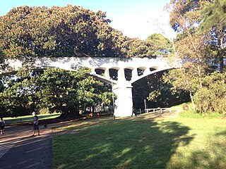
Johnston's Creek Sewer Aqueduct is a heritage-listed sewage aqueduct located in Hogan Park, off Taylor Street, Annandale, Inner West Council, Sydney, New South Wales, Australia. It was designed by William Julius Baltzer, an engineer in the NSW Public Works Department, and built by the Department in 1897. The property is owned by Sydney Water. It was added to the New South Wales State Heritage Register on 18 November 1999.

<span class="mw-page-title-main">Glebe and Wentworth Park railway viaducts</span> Bridge in New South Wales, Australia

The Glebe and Wentworth Park railway viaducts are a series of two heritage-listed railway bridges and arch viaducts that carry the Inner West Light Rail across Wentworth Park, Jubilee Park, and Johnstons Creek in the inner western Sydney suburb of Glebe in the City of Sydney local government area of New South Wales, Australia. They were designed by the New South Wales Government Railways and built from 1892 to 1922 by day labour. They are also known as Wentworth Park Viaduct, Jubilee Park Viaduct and Glebe Viaducts. The viaducts were added to the New South Wales State Heritage Register on 2 April 1999.

References

  1. 1 2 "Johnstons Bay". Geographical Names Register (GNR) of NSW. Geographical Names Board of New South Wales . Retrieved 23 June 2022. OOjs UI icon edit-ltr-progressive.svg
  2. "Johnstons Creek (gully)". Geographical Names Register (GNR) of NSW. Geographical Names Board of New South Wales . Retrieved 23 June 2022. OOjs UI icon edit-ltr-progressive.svg
  3. "Allan Truss Bridge, Former Federal Road Bridge". NSW State Heritage Register . Government of New South Wales. 23 November 2007. Retrieved 3 August 2013.
  4. "Bowstring Bridge". NSW State Heritage Register . Government of New South Wales. 23 November 2007. Retrieved 3 August 2013.
  5. "Johnstons Creek Sewage Aqueduct". Heritage item. Sydney Water. 30 August 2012. Retrieved 3 August 2013.
  6. "Johnstons Creek naturalisation". Sydney Water. 1 June 2020. Retrieved 1 June 2020.
  7. Cubby, Ben (17 September 2009). "Big fish in a small canal". The Sydney Morning Herald. Retrieved 3 August 2013.

34°36′S150°35′E / 34.600°S 150.583°E / -34.600; 150.583