
The Garigal National Park is a protected national park that is located within the North Shore and Forest District regions of Sydney, New South Wales, in eastern Australia. The 2,202-hectare (5,440-acre) national park is situated approximately 20 kilometres (12 mi) north of the Sydney central business district.

Ku-ring-gai Chase National Park is a national park on the northern side of Sydney in New South Wales, Australia. The 14,977-hectare (37,010-acre) park is 25 kilometres (16 mi) north of the Sydney central business district and generally comprises the land east of the M1 Pacific Motorway, south of the Hawkesbury River, west of Pittwater and north of Mona Vale Road. It includes Barrenjoey Headland on the eastern side of Pittwater.

Palm Beach is a suburb in the Northern Beaches region of Sydney, in the state of New South Wales, Australia. Palm Beach is located 41 kilometres (25 mi) north of the Sydney central business district, in the local government area of Northern Beaches Council. Palm Beach sits on a peninsula at the end of Barrenjoey Road near Pittwater and is the northernmost beach in the Greater Sydney Metropolitan area. The population of Palm Beach was 1,593 as at the 2016 census.

The Northern Beaches is a region within Northern Sydney, in the state of New South Wales, Australia, near the Pacific coast. This area extends south to the entrance of Port Jackson, west to Middle Harbour and north to the entrance of Broken Bay. The area was formerly inhabited by the Garigal or Caregal people in a region known as Guringai country.
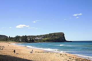
Avalon Beach is a northern beachside suburb of Sydney, in the state of New South Wales, Australia. It is 37 kilometres north of the Sydney central business district, in the local government area of Northern Beaches Council, in the Northern Beaches region. The area was previously called Avalon, with the name Avalon Beach being assigned during a change in boundaries and names in the Pittwater region in 2012.

Narrabeen is a beachside suburb of northern Sydney, New South Wales, Australia, 23 kilometres northeast of the business district, shared by the local government area of Northern Beaches Council and the Northern Beaches region. The bay was named Broken Bay by James Cook as he sailed past.
Dobroyd Head is a point or headland in the Northern Beaches local government area, in the suburb of Balgowlah Heights, New South Wales, Australia. It is part of the Sydney Harbour National Park, which contains examples of ecosystems at risk such as coastal heath. Tania Park is located to the immediate north-east, and contains the 2MWM 90.3 transmitter. There is a lookout sited on the headland named after Arabanoo, the first Aboriginal man to live among European settlers who was captured in Manly Cove in 1788.
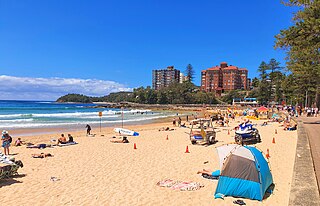
Manly Beach is a beach situated among the Northern Beaches of Sydney, Australia, in Manly, New South Wales. From north to south, the three main sections are Queenscliff, North Steyne, and South Steyne.

Manly is a beach-side suburb of northern Sydney, in the state of New South Wales, Australia. It is 17 kilometres (11 mi) north-east of the Sydney central business district and is currently one of the three administrative centres of the local government area of Northern Beaches Council. Manly has a long-standing reputation as a tourist destination, owing to its attractive setting on the Pacific Ocean and easy accessibility by ferry.

The Eora is primarily a construct developed by Aboriginal people from outside the Sydney region to represent themselves as an Aboriginal Australian people of New South Wales. Eora has been claimed to be the name given by the earliest European settlers to Aboriginal people belonging to the clans along the coastal area of what is now known as the Sydney basin, in New South Wales, Australia. The Eora derive their language from the Darug people, whose traditional lands lie in most of the Sydney basin, including those lands claimed to be Eora.

Dee Why is a coastal suburb of northern Sydney, in the state of New South Wales, Australia, 18 kilometres north-east of the Sydney central business district. It is the administrative centre of the local government area of Northern Beaches Council and, along with Brookvale, is considered to be the main centre of the Northern Beaches region.
Elanora Heights is a suburb in northern Sydney, in the state of New South Wales, Australia. Elanora Heights is 27 kilometres north-east of the Sydney central business district, in the local government area of Northern Beaches Council. Elanora Heights is part of the Northern Beaches region.
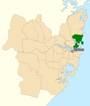
The Division of Warringah is an Australian electoral division in the state of New South Wales.
North Curl Curl is a suburb in northern Sydney, in the state of New South Wales, Australia 19 kilometres north-east of the Sydney central business district, in the local government area of Northern Beaches Council. It is part of the Northern Beaches region.

Mount Kuring-gai is an outer suburb of Northern Sydney, in the state of New South Wales, Australia. Mount Kuring-gai is located 31 kilometres north-west of the Sydney central business district, in the local government area of Hornsby Shire.
Curl Curl is a suburb of northern Sydney in the state of New South Wales, Australia, 18 kilometres (11 mi) north-east of the Sydney central business district, in the local government area of Northern Beaches Council. It is part of the Northern Beaches region.
Coasters Retreat is a road-inaccessible suburb in northern Sydney, in the state of New South Wales, Australia, 42 kilometres north of the Sydney central business district, in the local government area of Northern Beaches Council.
Bombora is an indigenous Australian term for an area of large sea waves breaking over a shallow area such as a submerged rock shelf, reef, or sand bank that is located some distance from the shoreline and beach surf break. In slang, it is also called a bommie.

Freshwater is a suburb of northern Sydney, in the state of New South Wales, Australia. Freshwater is located 17 kilometres (11 mi) north-east of the Sydney central business district, in the local government area of Northern Beaches Council and is part of the Northern Beaches region.

The Northern Beaches Council is a local government area located in the Northern Beaches region of Sydney, in the state of New South Wales, Australia. The council was formed on 12 May 2016 after the amalgamation of Manly, Pittwater, and Warringah councils.

