Upper Nepean Scheme

Last updated
Wall of the Cordeaux Dam, one of the dams in the Upper Nepean Scheme CordeauxDam.JPG
Wall of the Cordeaux Dam, one of the dams in the Upper Nepean Scheme

The Upper Nepean Scheme is a series of dams and weirs in the catchments of the Cataract, Cordeaux, Avon and Nepean rivers of New South Wales, Australia. The scheme includes four dams and two weirs, and a gravity-fed canal system that feeds into a large storage reservoir to provide water to the Macarthur and Illawarra regions, the Wollondilly Shire, and metropolitan Sydney. The four dams and associated infrastructure are individually listed on the New South Wales State Heritage Register. [1] [2] [3] [4]

Contents

History

By 1867, Sydney was outgrowing the water supply available from Botany Swamps and the Governor (Sir John Young) appointed a Commission to recommend a future water supply. [5] In 1869, the Commission recommended the Upper Nepean Scheme. [6] This comprised weirs on the Cataract and Nepean rivers, a storage reservoir at Prospect and 101.79 kilometres (63.25 mi) of pipelines, tunnels, canals and aqueducts to bring water from the 900 square kilometres (347 sq mi) catchment area to Sydney. Work on the Scheme began in 1880 [7] and was completed in 1888. [8] :15–17 The Scheme was a significant feat of engineering at the time of construction.

In June 1885 Sydney was in the grip of a severe drought and the Upper Nepean Scheme was incomplete. The Government accepted an offer from Hudson Brothers to bridge the gaps and deliver 14 megalitres; 3.6 million US gallons (3×10^6 imp gal) of water per day into Botany Swamps. Duplicating the entire length of the half built permanent scheme this became known as Hudsons' Temporary Scheme and was turned into the swamps on 30 January 1886. [9] :64 [10] This emergency work was dismantled as the main scheme was completed. [8] :18–19

As originally built, the Upper Nepean Scheme was capable of supporting an estimated population of 540,000. By 1902, Sydney had a population of 523,000 and was again in the grip of a severe drought. A Royal Commission appointed to report on Sydney's water supply recommended a dam on the Cataract River and construction commenced in the same year. Dams were subsequently built on each of the Cordeaux, Avon and Nepean rivers, with the last being completed in 1935. Each dam includes a public picnic area. [8] :25–31 In total, the four dams hold 483,600 ML (1.064×10¹¹ imp gal; 1.278×10¹¹ US gal) and can safely provide 353 ML (78×10^6 imp gal; 93×10^6 US gal) per day. [8] :268

The Scheme is now managed by the Sydney Catchment Authority.

Further supplementary water supply is provided by a feed from the Shoalhaven Scheme through various pumps, pipes, cuts and diversions.

Associated dams

Cataract Dam

The Cataract Dam is a heritage-listed gravity dam with an unlined side spillway extending from the left abutment. It is 56 metres (183 ft) tall, 247 metres (811 ft) long and holds 97,190 ML (2.138×10¹⁰ imp gal; 2.567×10¹⁰ US gal) of water. [8] :268 Cataract Dam was the first dam built in the Upper Nepean Scheme, it was also first dam in Australia to use pre-cast moulded concrete blocks for the upstream face of the dam. [1] The core of the dam consists of large 2-to-4.5- long-ton (2.03 to 4.57  t ; 2.24-to-5.04- short-ton ) sandstone blocks, quarried onsite and cemented together. The downstream face is of mass poured basalt concrete, with a basalt facing. A readily accessible source of suitable rock was located some distance away at Sherbrooke, also known as Ferndale, situated near the top of Bulli Pass. To transport the basalt from the quarry to the dam construction site, a 2 ft (610 mm) gauge steam tramway, 8.8 km (5.5 mi) long, was constructed. [11] Dam construction began in 1902 and was completed in 1907, and the spillway was widened in 1915. [8] :27–28 Ernest Macartney de Burgh was the supervising engineer for the project from 1904. [12] Poet Banjo Paterson wrote a satirical ballad "The Dam that Keele Built" about the politics behind the construction of Cataract Dam. [13]

Cordeaux Dam

The Cordeaux Dam is a heritage-listed arch dam across the Cordeaux River with an unlined side spillway on the left abutment. It is 58 metres (191 ft) high, 404 metres (1,327 ft) long and creates a reservoir which holds 93,640 ML (2.060×10¹⁰ imp gal; 2.474×10¹⁰ US gal). Construction began in 1918 and was completed in 1926 [8] :268 [14] at a cost of 945,000. [2] The wall consists of large sandstone blocks, quarried onsite and cemented together, faced with a combination of bluestone and sandstone concrete. [8] :28–29 The dam featured a number of improvements in design and construction on the earlier-completed Cataract Dam. These included contraction joints between units of construction placed at intervals of 27 metres (90 ft); inspection galleries at upper and lower levels, together with piping for registering any ground water pressure. [2] The blue metal used in the construction of the dam was supplied from the Government Quarries at Kiama and brought by rail to Douglas Park. From here it was conveyed by aerial ropeway across the Nepean Gorge to an interchange on the eastern side where the material was transferred to a 2 ft (610 mm) gauge steam tramway to a point adjacent to the dam site. [15]

Avon Dam

The Avon Dam is a heritage-listed arch dam across the Avon River; it is 72 metres (237 ft) tall, 223 metres (732 ft) long and its reservoir holds 146,700 ML (3.23×10¹⁰ imp gal; 3.88×10¹⁰ US gal). It has the largest capacity of all the dams in the Scheme. Construction of the heritage-listed dam wall began in 1921 and was completed in 1927 [8] :268 [16] at a cost of 1,047,000. [3] The dam construction and materials are the same as Cordeaux. [8] :29 All materials for construction were transported from Bargo railway station on a specially built road, all the other dams in the scheme used rail transport. [14] There were some light tramways constructed at the dam site, however it would appear that no locomotives were employed; skips and other items being moved by winch, horse or manpower. [17]

Nepean Dam

The Nepean Dam is a heritage-listed arch dam across the Nepean River; it is 82 metres (269 ft) tall and 216 metres (709 ft) long. Construction on the Dam began in 1926, construction was delayed for two years during the Depression, it was finally completed in 1935. [8] :268 [18] The capacity is listed variously as 67,730 to 81,400 ML (1.490×10¹⁰ to 1.791×10¹⁰ imp gal; 1.789×10¹⁰ to 2.150×10¹⁰ US gal). [18] [8] :268 The Nepean Reservoir has a small storage capacity in relation to its large catchment area of 319 square kilometres (123 sq mi). While its capacity is much the same as that of Cataract and Cordeaux Reservoirs, its catchment basin is two and a half times as extensive as Cataract and three and a half times as extensive as Cordeaux. The Nepean Reservoir therefore fills more rapidly and, under normal conditions, is drawn upon more freely than the other reservoirs. The dam is located at an elevation of 325 metres (1,066 ft) above sea level and the construction cost was 2,062,000. [4]

Railway sidings were established on the Main Southern railway line at a point between Bargo and Yerrinbool. Transport to the dam site was again by light railway, on this occasion of standard gauge. This avoided transhipment from the Government vehicles bringing materials from large commercial quarries, effectively making the line an extended privately owned siding. The line was 4 km (2.5 mi) long through gentle countryside. Trains were worked by a variety of locomotives, including a former Sydney Steam Tram Motor. Additionally, there was a system of narrow (610 mm / 2 ft) gauge lines in use at the dam construction site. [19]

Additional work was carried out on the spillway between 1943 and 1947 to prevent scouring of the dam foundations. [8] :31

See also

Related Research Articles

Warragamba Dam Dam in Warragamba, New South Wales

Warragamba Dam is a heritage-listed dam in the outer South Western Sydney suburb of Warragamba, Wollondilly Shire in New South Wales, Australia. It is a concrete gravity dam, which creates Lake Burragorang, the primary reservoir for water supply for the city of Sydney. The dam wall is located approximately 65 kilometres (40 mi) W of Sydney central business district, 4½ km SW of the town of Wallacia, and 1 km NW of the village of Warragamba.

Lake Burragorang

Lake Burragorang is a man-made reservoir in the lower Blue Mountains of New South Wales, Australia, serving as a major water supply for greater metropolitan Sydney. The dam impounding the lake, the Warragamba Dam, is located approximately 60 kilometres (37 mi) southwest of the Sydney central business district.

The Waranga Dam is a major earthfill embankment dam with an uncontrolled spillway located approximately 150 kilometres (93 mi) north of Melbourne in the North Central region of the Australian state of Victoria. The impounded off-stream reservoir is Waranga Basin and forms part of the Goulburn River irrigation system, irrigating an area of 626 square kilometres (242 sq mi). The dam and reservoir are located in Shire of Campaspe near the City of Greater Shepparton and is located 8 kilometres (5.0 mi) northeast of Rushworth, 12 kilometres (7.5 mi) southwest of Tatura, and near Murchison. When full, the reservoir covers an area of 58.5 square kilometres (22.6 sq mi).

Cataract Dam Dam in Cataract, New South Wales

The Cataract Dam is a heritage-listed dam in Cataract, New South Wales, Australia, provides water to the Macarthur and Illawarra regions, the Wollondilly Shire, and metropolitan Sydney. It is one of four dams and weirs in the catchment of the Upper Nepean Scheme. Completed in 1907 under the supervision of Ernest Macartney de Burgh, the dam is currently owned by Water NSW, an agency of the Government of New South Wales. The dam was listed on the NSW State Heritage Register on 18 November 1999.

Cordeaux Dam Dam in Cordeaux, New South Wales

The Cordeaux Dam is a heritage-listed dam in Cordeaux, New South Wales, Australia. It provides water to the Macarthur and Illawarra regions, the Wollondilly Shire, and metropolitan Sydney. It is one of four dams and weirs in the catchment of the Upper Nepean Scheme. Completed in 1926 under the supervision of Ernest Macartney de Burgh, the dam is owned by Water NSW, an agency of the Government of New South Wales. It was listed on the New South Wales State Heritage Register on 18 November 1999.

Nepean Dam Dam in Bargo, New South Wales

The Nepean Dam is a heritage-listed dam split across Avon in the Wingecarribee Shire and Bargo in the Wollondilly Shire, both in New South Wales, Australia. The reservoir created by the dam spreads across Avon, Bargo and also Yerrinbool in Wingecarribee Shire. The Nepean Dam is one of four dams and weirs in the catchment of the Upper Nepean Scheme, in New South Wales, Australia, and provides water to the Macarthur and Illawarra regions, the Wollondilly Shire, and metropolitan Sydney. Completed in 1935 under the supervision of Ernest Macartney de Burgh, the dam is currently managed by the Sydney Catchment Authority and is listed on the New South Wales State Heritage Register.

Avon Dam Dam in Avon Dam, New South Wales

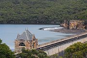
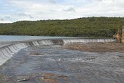
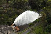
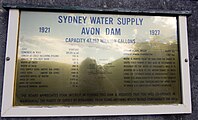
The Avon Dam is a heritage-listed dam in Avon, Wingecarribee Shire, New South Wales, Australia. It is one of four dams and weirs in the catchment of the Upper Nepean Scheme, providing water to the Macarthur and Illawarra regions, the Wollondilly Shire, and metropolitan Sydney. The arch dam across the Avon River was completed in 1927 under the supervision of Ernest Macartney de Burgh, the dam is currently managed by the Sydney Catchment Authority and is listed on the New South Wales State Heritage Register.

Woronora Dam Dam in south of Sydney, New South Wales

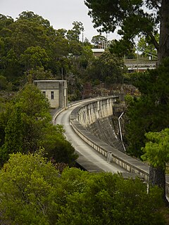
The Woronora Dam is a heritage-listed concrete gravity dam with an uncontrolled serpentine spillway across the Woronora River, located south of Greater Metropolitan Sydney, in the suburb of Woronora Dam, Sutherland Shire, New South Wales, Australia. The principal purpose of the dam is for potable water supply for Sydney's southern suburbs and the northern suburbs of the Illawarra region. The impounded 71,790-megalitre reservoir is also called Woronora Dam and is sometimes incorrectly called Lake Woronora. The dam was designed by G. E. Haskins, Chief Engineer and the Metropolitan Water, Sewerage and Drainage Board of NSW (MWS&DB) and built from 1927 to 1941 by the MWS&DB. The property is owned by the Sydney Catchment Authority, an agency of the Government of New South Wales. It was added to the New South Wales State Heritage Register on 18 November 1999.

Maroon Dam Dam in South East Queensland

The Maroon Dam is a rock and earth-fill embankment dam with an un-gated spillway across the Burnett Creek that is located in the South East region of Queensland, Australia. The main purpose of the dam is for irrigation of the Scenic Rim Regional Council region. The impounded reservoir is also called Maroon Dam.

Prospect Reservoir Dam in Western Sydney, New South Wales

The Prospect Reservoir is a heritage-listed 50,200-megalitre potable water supply and storage reservoir created by the Prospect Dam, across the Prospect Creek located in the Western Sydney suburb of Prospect, in New South Wales, Australia. The eastern bounds of the reservoir are a recreational area and the western periphery are within the bounds of Western Sydney Parklands. It was added to the New South Wales State Heritage Register on 18 November 1999.

Lower Prospect Canal Reserve

The Lower Prospect Canal Reserve is a heritage-listed former farm and public water supply canal and now bushy corridor and nature reserve stretching 7.7 kilometres (4.8 mi) through the heart of suburban Sydney, New South Wales, Australia. The lineal corridor stretches from Prospect Reservoir to Sydney Water Pipehead at Albert Street, Guildford with the majority of the reserve located in Greystanes, which is a suburb within the Cumberland Council area.

The Fairbairn Dam is an earth-filled embankment dam across the Nogoa River, located southwest of Emerald in Central Queensland, Australia. Constructed in 1972 for the primary purpose of irrigation, the impoundment created by the dam serves as one of the major potable water supplies for the region and assists with some flood mitigation.

Avon River (Wollongong) River in the Southern Highlands and Macarthur districts of New South Wales, Australia

The Avon River, a perennial river of the Hawkesbury-Nepean catchment, is located in the Southern Highlands and Macarthur districts of New South Wales, Australia.

Cordeaux River

The Cordeaux River, a perennial river of the Hawkesbury-Nepean catchment, is located in the Southern Highlands and Macarthur regions of New South Wales, Australia.

Warragamba River River in New South Wales, Australia

The Warragamba River, a river that is part of the Hawkesbury-Nepean catchment, is located in the Macarthur region of New South Wales, Australia.

Liverpool Offtake Reservoir is a small reservoir in Cecil Hills, New South Wales. Built along with the Upper Nepean Scheme it replaced the Liverpool Weir supply.

Manly Dam Dam

The Manly Dam is a heritage-listed dam near King Street, Manly Vale with a reservoir extending into Allambie Heights, both in the Northern Beaches Council local government area of New South Wales, Australia. The reservoir is located within the Manly Dam Reserve. The dam was designed by the NSW Department of Public Works and built in 1892 by the Department. The reservoir and dam is owned by Sydney Water, an agency of the Government of New South Wales. The reservoir and dam was added to the New South Wales State Heritage Register on 18 November 1999.

Upper Canal System

The Upper Canal System, also called the Southern Railway Aqueduct and the Cataract Tunnel, is a heritage-listed operational gravity-fed aqueduct that supplies some of the potable water for Sydney, in New South Wales, Australia. The aqueduct comprises 54 kilometres (34 mi) of open canals, tunnels, and closed pipelines that connect the Upper Nepean Scheme with the Prospect Reservoir. The aqueduct is managed by the Sydney Catchment Authority on behalf of WaterNSW, an agency of the Government of New South Wales. It was listed on the New South Wales State Heritage Register on 18 November 1999.

Kiama Reservoirs

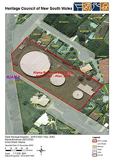
The Kiama Reservoirs are heritage-listed reservoirs at Irvine Street, Kiama, Municipality of Kiama, New South Wales, Australia. They are owned by Sydney Water. It was added to the New South Wales State Heritage Register on 15 November 2002.

Guildford West pipehead and water supply canal

The Guildford West pipehead and water supply canal is a heritage-listed sewerage infrastructure and water supply canal located at Frank Street, Guildford in the Cumberland Council local government area of New South Wales, Australia. It is also known as Headworks; Industrial Archaeological Site. The property is owned by Sydney Water, an agency of the Government of New South Wales. It was added to the New South Wales State Heritage Register on 15 November 2002.

References

  1. 1 2 "Cataract Dam". New South Wales State Heritage Register . Office of Environment & Heritage . Retrieved 13 April 2012.
  2. 1 2 3 "Cordeaux Dam". New South Wales State Heritage Register . Office of Environment & Heritage . Retrieved 29 September 2017.
  3. 1 2 "Avon Dam". New South Wales State Heritage Register . Office of Environment & Heritage . Retrieved 29 September 2017.
  4. 1 2 "Nepean Dam". New South Wales State Heritage Register . Office of Environment & Heritage . Retrieved 29 September 2017.
  5. "THE GOVERNMENT GAZETTE". The Sydney Morning Herald . Vol. LVI, no. 9159. 28 September 1867. p. 7. Retrieved 22 May 2016 via National Library of Australia.
  6. "REPORT OF THE WATER SUPPLY COMMISSION". The Empire . No. 5607. New South Wales, Australia. 22 October 1869. p. 4. Retrieved 5 October 2016 via National Library of Australia.
  7. "THE WATER SUPPLY OF SYDNEY". The Sydney Morning Herald . No. 13, 060. 10 February 1880. p. 6. Retrieved 22 May 2016 via National Library of Australia.
  8. 1 2 3 4 5 6 7 8 9 10 11 12 13 Aird, W. V. (1961). The Water Supply, Sewerage and Drainage of Sydney (PDF). Metropolitan Water Sewerage and Drainage Board.
  9. Henry, F. J. J. (1939). The water supply and sewerage of Sydney (PDF). Metropolitan Water Sewerage and Drainage Board.
  10. "THE TEMPORARY WATER SUPPLY". The Sydney Morning Herald . No. 14, 931. 1 February 1886. p. 6. Retrieved 30 April 2016 via National Library of Australia.
  11. Longworth, Jim (July 1993). "Construction Railways of the Upper Nepean Dams - Cataract Dam". Australian Railway Historical Society Bulletin : 163–174.
  12. Antill, J. M. (1981). "De Burgh, Ernest Macartney (1863 - 1929)". Australian Dictionary of Biography, Volume 8. MUP. p. 266. Retrieved 22 April 2007.
  13. "Cataract Dam - Sydney Catchment Authority" . Retrieved 11 March 2012.
  14. 1 2 "Cordeaux Dam - Sydney Catchment Authority" . Retrieved 11 March 2012.
  15. Longworth, Jim (October 1993). "Construction Railways of the Upper Nepean Dams - Cordeaux Dam". Australian Railway Historical Society Bulletin : 249–259.
  16. "Avon Dam - Sydney Catchment Authority" . Retrieved 11 March 2012.
  17. Longworth, Jim (January 1994). "Construction Railways of the Upper Nepean Dams - Avon Dam". Australian Railway Historical Society Bulletin : 14–19.
  18. 1 2 "Nepean Dam - Sydney Catchment Authority" . Retrieved 11 March 2012.
  19. Longworth, Jim (May 1994). "Construction Railways of the Upper Nepean Dams - Nepean Dam". Australian Railway Historical Society Bulletin : 137–153.

Attribution

CC BY icon-80x15.png This Wikipedia article was originally based on the "New South Wales State Heritage Register" published by the Government of New South Wales under CC-BY 3.0 AU licence (accessed on 13 April 2012); and based on the "New South Wales State Heritage Register" published by the Government of New South Wales under CC-BY 3.0 AU licence (accessed on 29 September 2017); and based on the "New South Wales State Heritage Register" published by the Government of New South Wales under CC-BY 3.0 AU licence (accessed on 29 September 2017); and based on the "New South Wales State Heritage Register" published by the Government of New South Wales under CC-BY 3.0 AU licence (accessed on 29 September 2017).

Further reading

Coordinates: 34°13′40″S150°44′39″E / 34.227699°S 150.744232°E / -34.227699; 150.744232 (Broughtons Pass)