Macarthur, New South Wales

Last updated

Macarthur
New South Wales
Razorbackrangepicton.jpg
Hills of the Razorback Range located in between Camden and Picton.
Population309,792[ citation needed ] (2016)
LGA(s) Wollondilly, Campbelltown, Camden
Region Greater Sydney
State electorate(s) Campbelltown, Macquarie Fields, Camden, Wollondilly
Federal division(s) Macarthur, Werriwa, Hume
Localities around Macarthur:
Greater Western Sydney South Western Sydney South Western Sydney
Blue Mountains Macarthur Southern Sydney
Southern Tablelands Southern Highlands Illawarra

Macarthur is a region in the south-west part of the Greater Sydney area, in the state of New South Wales, Australia. The region includes the local government areas of the City of Campbelltown, Camden Council, and Wollondilly Shire. It covers an area of 3,067 square kilometres and has a population of close to 310,000 residents. [1] The region geographically forms the foothills between the Blue Mountains and Southern Highlands regions.

Contents

The region is bounded at the north by Glenfield; at the south by Yanderra; at the east by the town of Appin; and at the west by the hamlet Nattai.

Most of the area is taken up by the semi-rural Wollondilly Shire; most of the population lives within the satellite city of Campbelltown and its surrounding suburbs.

The region is one of the fastest-growing regions in the Sydney metropolitan area, with many new modern suburbs sprouting up in recent decades such as Glen Alpine, Macquarie Links, Harrington Park, Blair Athol, Mount Annan, Currans Hill, Englorie Park, Picton, Oran Park, Gregory Hills, Gledswood Hills, Spring Farm and Catherine Field. [2]

Etymology

The region is named after John Macarthur and Elizabeth Macarthur who were founders and pioneers of the Australian wool industry. Founded on land owned by the Macarthurs and surveyed by Sir Thomas Mitchell, the town of Camden was named for Lord Camden, who, during his brief tenure as Secretary of State for War and the Colonies had secured the initial land grant for John Macarthur who was then in England. The original Macarthur family property covered the three local councils (Camden Council, Campbelltown City Council and Wollondilly Shire) that are within the region.

Geography

The region is generally regarded as the area where the city of Sydney meets rural countryside of regional New South Wales, and is considered to be part of the south west part of the Greater Sydney area. Campbelltown and Camden were once rural towns which formed the nucleus of new urban communities created following the Three Cities Structure Plan 1973.

The Wollondilly Shire which makes up the largest Southern part of the region is a mostly rural region with small scale industry and commerce. Notably, the Wollondilly supplies much of Sydney Metropolitan and surrounding areas with water from Warragamba Dam, Cataract Dam in Appin, Cordeaux Dam in Wilton and Avon and Nepean Dams even though located in the Wingecarribee Shire is accessed via road through Wollondilly's Bargo.

The region has thus far recorded two earthquakes in history – one occurring in Appin on March 17, 1999, and one in Picton on March 9, 1973. [3] The Picton one had a damage total of $2.8 million, with some minor damage in Bowral and Wollongong. [4] The earthquakes had a magnitude scale of 4.8 and 5.6, respectively.

Councils

The administrative towns of the Macarthur Region are:

Camden Council announced in May 2012 that it will transfer its administrative headquarters to Oran Park. [5]

History

The history of the region begins over 40,000 years ago and is contained in the continuing culture of the Tharawal people. The land still contains reminders of their past lives in rock engravings, cave paintings, axe grinding grooves and shell middens. Their culture also remains in the surviving songs, stories and descendants. The lands of the Tharawal language Nation extended from approximately Botany Bay to Shoalhaven and to the foothills of the mountain ranges. The principal symbol of the Tharawal nation is the lyrebird.

European history began in 1788 shortly after settlement at Sydney Cove, when the colony's entire herd of cattle (four cows and two bulls) strayed from their enclosure and were lost. In 1795 a greatly enlarged herd of 61 cattle were discovered on the grassy land between the Nepean River and Georges River. This area was promptly named the "Cowpastures" – and was deemed a restricted area to provide ongoing protection for the herd; this restriction was short-lived as the herd, deemed too aggressive to be tamed, was destroyed. The early settlement of the area was described by Lachlan Macquarie in his journals, whose accounts include the description of Elizabeth Macarthur being met in a 'miserable' bark hut, the only accommodation then existing at Camden Park. In 1803, John Macarthur had been granted 5,000 acres (20 km2) at the Cowpastures and began grazing Merino sheep. His sons William and James introduced viticulture and a commercial nursery, and a successful dairy was founded by Emily Stone, James' wife.

The region is steeped in history with statesmen, adventurers, larrikins and villains all having an association with the Macarthur region which makes it a tourist destination.

Local attractions

Major attractions of Camden are:

Mount Annan Botanic Gardens is a 416-acre (1.68 km2) botanic garden opened in 1988. It is currently the largest botanic gardens in Australia and is administered by the Royal Botanic Gardens, Sydney. It is home to a large collection of native plants, and includes facilities such as picnic areas (with barbecues), walking trails and a restaurant.

Camden Park House built by the Macarthurs. Camden Park house.jpg
Camden Park House built by the Macarthurs.

Camden Park Estate was the country property of Australian Wool Pioneers John Macarthur and his wife Elizabeth Macarthur, and became the principal residence of their family after John's death. Centrepiece of the original 2023.5 hectares (5000 acres) granted to Macarthur by the Governor of New South Wales, at the request of Lord Camden, is Camden Park House, designed by John Verge in the neo-Palladian style favoured by the colony's wealthy pastoral 'exclusives', and built between 1832 and 1834; Macarthur himself did not live to see the house completed. Currently, the house remains on 388.5 hectares (960 acres) of the original estate. Macarthur's descendants still reside on the house and property.

Adjacent to Camden Park, though once within its extent, is Belgenny Farm, which is popularly called the "Birthplace of Australia's Agriculture". Designed by architect Henry Kitchen, Belgenny Cottage was built c1821 and was mentioned in Kitchen's submission to Commissioner John Thomas Bigge's enquiry into the state of the colony under Governor Lachlan Macquarie. This original 'cottage ornée', which was demolished in the early 1900s and replaced with the current weatherboard structure, was used by the family when visiting the property until the construction of Camden Park House on an adjacent hilltop. John Macarthur himself died in the cottage in 1834, and was buried in the family cemetery immediately to the south. Currently, the farm is home to descendants of sheep that were brought by the Macarthurs and has a functioning vineyard that produces wine as well as orchards. A 2010 archaeological survey and dig to the north of Belgenny may have determined the location of the original 'miserable hut'.

Camden Valley Golf Resort, opened in 1964 by architect Prosper Ellis, is a popular 27 hole golf course. [6] Facilities include a clubhouse and brasserie.

Wollondilly Shire

Major attractions of Wollondilly are:

Sydney Skydivers is Australia's largest multi-state skydive operator in Australia and operates a Skydiving Centre off the Hume Highway junction off Picton. This Skydiving Centre is the closest self-contained Skydiving Centre near Sydney that does tandem and various other forms of skydiving. [7]

The Centre is located 55min from the Sydney CBD and operates 7 days a week. The head office of Sydney Skydivers is located at 677 Tower Road Bankstown Airport. Skydiving is only from the centre at Picton.

Antill Park Country Golf Club is the largest golf course in the Wollondilly Shire. It has 18 holes. Moreover, the Golf Clubhouse was built in 1863 by John Macquarie Antill Snr., and is historic to the local area. [8]

Wirrimbirra Sanctuary is a small 95 hectare reserve and property that is under the authority of the National Trust of Australia that was given by Thistle Harris who opened the park in the 1960s. Thistle opened reserve as a tribute to her late husband and preserve 'Bargo Brush' plants and animals as Bargo is believed to be the first areas where colonial explorers saw the lyrebird, koala and wombat. [9]

The sanctuary is open to the public where it promotes Australian environmental and wildlife issues, propagates Australian native plants and showcase native Australian animals. Currently, a dingo sanctuary is being constructed. [9]

Mushroom Tunnel is located just off the Remembrance Driveway (Old Hume Highway) heading towards Tahmoor and was built in 1867. [10] It is considered one of the earliest pre-Federation railway tunnels in New South Wales. In 1919 the 65-metre-long tunnel fell into disuse when a new railway deviation was built. The tunnel then served as a mushroom farm and ammunition storage facility during the war years. [10] Currently the tunnel is empty although it is popular with ghost-hunters due to many local folk tales claiming that it is haunted. Subsequently, it has been featured by both print and television media.

Thirlmere Lakes National Park is part of the Blue Mountains Heritage Area in which the park consists of 5 important freshwaters lakes that are abundant in waterbirds and native reeds. The lakes are among the last undisturbed lakes within the proximity of Sydney and are believed to have high ecosystem-related and environmental scientific value. [11] (For more information, see Thirlmere Lakes National Park .)

Campbelltown City

Major attractions of Campbelltown are:

Macarthur Square is the biggest shopping centre in the Macarthur region and caters for the entire region. It contains over 300 shops and includes the department stores Big W, Target and David Jones. Macarthur Square is located in the suburb of Ambarvale, New South Wales, which is about 1 km south of Campbelltown's CBD. It is located adjacent to Macarthur railway station and University of Western Sydney, Macarthur. [12]

Eschol Park House EscholParkNSWEPhouse.jpg
Eschol Park House
Campbelltown Arts Centre Campbelltown Arts Centre.jpg
Campbelltown Arts Centre

Campbelltown City Arts Centre is one of the largest art galleries and exhibitions centres in the Macarthur Region. It is home to Campbelltown Bicentennial Art Gallery, which contains both permanent contemporary art collections and temporary exhibitions. The centre also does art workshops and performing arts. [13]

The centre is well known for promoting multicultural-themed art and Indigenous Australian art. [14]

The Japanese Tea Garden is also found within the arts centre. It was a gift from the Japanese city of Koshigaya, the sister city of Campbelltown.

The Campbelltown Sports Stadium is located in Leumeah. Campbelltown Stadium.jpg
The Campbelltown Sports Stadium is located in Leumeah.

The Campbelltown Sports Stadium caters for 21,000 and has grandstand seating for 9,000. It is one of the home stadiums for the Wests Tigers NRL Team. Moreover, the team's leagues club is located adjacent to the stadium as well as an athletics centre and large tennis court complex. Campbelltown Sports Stadium is also the home of the region's new A-League club Macarthur FC.

Campbelltown Catholic Club is the largest club in the Macarthur Region. The club notably owns and has shares in The Cube (Campbelltown Convention Centre), Aquafit Gym and the Rydges Hotel located adjacent to the club. [15]

Organisations and media

Astronomy

The Campbelltown Rotary Observatory is located at the University of Western Sydney (Campbelltown Campus) and Macarthur Astronomical Society holds public lectures at the Macarthur Astronomy Forum and public observing nights at selected locations.

Related Research Articles

<span class="mw-page-title-main">Campbelltown, New South Wales</span> City in New South Wales, Australia

Campbelltown is a suburb located on the outskirts of the metropolitan area of Sydney, New South Wales, Australia. It is located in Greater Western Sydney 53 kilometres (33 mi) south-west of the Sydney central business district by road. Campbelltown is the administrative seat of the local government area of the City of Campbelltown. It is also acknowledged on the register of the Geographical Names Board of New South Wales as one of only four cities within the Sydney metropolitan area.

<span class="mw-page-title-main">South Western Sydney</span> Region in New South Wales, Australia

South Western Sydney is a region of the metropolitan area in southwest Sydney, New South Wales, Australia. It is part of the predominantly working class area of Greater Western Sydney. The region lies in the Cumberland Plain.

<span class="mw-page-title-main">Thirlmere, New South Wales</span> Town in New South Wales, Australia

Thirlmere is a small semi-rural town in the Macarthur Region of Sydney in New South Wales, Australia, in the Wollondilly Shire. Popularly known for its railway origins, the town is located 89 km south west of the Sydney Central Business District. At the 2021 census, Thirlmere had a population of 4,986.

<span class="mw-page-title-main">Division of Hume</span> Australian federal electoral division

The Division of Hume is an Australian electoral division in the state of New South Wales.

<span class="mw-page-title-main">Picton railway station</span> Railway station in New South Wales, Australia

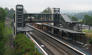
Picton railway station is a heritage-listed railway station located on the Main Southern line in the south-western Sydney suburb of Picton in the Wollondilly Shire local government area of New South Wales, Australia. It was built from 1863 to 1919. It is also known as the Picton Railway Station group. The property was added to the New South Wales State Heritage Register on 2 April 1999. The station opened on 1 July 1869. The station is unusually sited, with southbound journeys actually heading north out of the station before traversing a 225 degree horseshoe curve to again head south, and likewise northbound services heading south before rounding a number of curves to resume their true direction.

<span class="mw-page-title-main">Picton, New South Wales</span> Town in New South Wales, Australia

Picton is a small town in the Macarthur Region of New South Wales, Australia, in the Wollondilly Shire, in south-western Sydney. The town is located approximately 90 kilometres south-west of the Sydney CBD, close to Camden and Campbelltown. It is also the administrative centre of Wollondilly Shire.

<span class="mw-page-title-main">Wollondilly Shire</span> Local government area in New South Wales, Australia

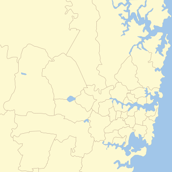
Wollondilly Shire is a periurban local government area, located on the south west fringe of the Greater Sydney area in New South Wales, Australia, parts of which fall into the Macarthur, Blue Mountains and Central Tablelands regions in the state of New South Wales, Australia. Wollondilly is seen as the transition between Regional NSW and the Greater Sydney Region, and is variously categorised as part of both. Wollondilly Shire was created by proclamation in the NSW Government Gazette on 7 March 1906, following the passing of the Local Government (Shires) Act 1905, and amalgamated with the Municipality of Picton on 1 May 1940.

Bargo is a town in the Macarthur Region of Sydney in New South Wales, Australia, in the Wollondilly Shire. It is located approximately halfway between Campbelltown and Bowral, about 100 km south west of the Sydney CBD.

<span class="mw-page-title-main">Buxton, New South Wales</span> Town in New South Wales, Australia

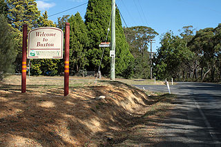
Buxton is a small village in Macarthur Region of Sydney in New South Wales, Australia, in Wollondilly Shire. At the 2021 census, Buxton had a population of 2,071 people. Its name comes from the town of Buxton, Derbyshire.

<span class="mw-page-title-main">Douglas Park, New South Wales</span> Suburb of Wollondilly, New South Wales, Australia

Douglas Park is a town of the Macarthur Region in New South Wales, Australia in Wollondilly Shire. It is near the Hume Highway, the F5 Freeway and on the Main Southern railway line. Its station is served by NSW TrainLink's Southern Highlands Line. It is about 80 km southwest of Sydney. In 2016, Douglas Park had a population of 1,362.

<span class="mw-page-title-main">Tahmoor, New South Wales</span> Town in New South Wales, Australia

Tahmoor is a small town in the Macarthur Region of New South Wales, Australia, in Wollondilly Shire.

<span class="mw-page-title-main">Electoral district of Wollondilly</span> Austrialian state-level electoral district

Wollondilly is an electoral district of the Legislative Assembly in the Australian state of New South Wales. It is currently represented by independent Judy Hannan, who defeated sitting member Nathaniel Smith at the 2023 New South Wales state election.

<span class="mw-page-title-main">Appin, New South Wales</span> Town in New South Wales, Australia

Appin is a town on the south-west fringe of Sydney in the Macarthur Region in Tharawal country near its boundary with Gandangara country, New South Wales, Australia in Wollondilly Shire. It is situated about 16 kilometres (9.9 mi) south of Campbelltown and 35 kilometres (22 mi) northwest of Wollongong.

<span class="mw-page-title-main">Couridjah, New South Wales</span> Suburb of Wollondilly Shire, New South Wales, Australia

Couridjah is a small town in the Macarthur Region of New South Wales, Australia, in Wollondilly Shire. It was previously known officially as "Village of Couridjah". At the 2016 census, Couridjah had a population of 303.

<span class="mw-page-title-main">The Oaks, New South Wales</span> Town in New South Wales, Australia

The Oaks is a town in the Macarthur Region of New South Wales, Australia in Wollondilly Shire on the south western edge of the Sydney Basin. The Oaks is located 82 kilometres (51 mi) south-west of Sydney via the Hume Highway, 13 kilometres (8 mi) west of Camden and 290m above sea-level. At the 2016 census, The Oaks and the surrounding area had a population of 2,525.

Phillip John Costa is an Australian politician. He was a Labor Party member of the New South Wales Legislative Assembly from 2007 until 2011, representing the electorate of Wollondilly. He served as Minister for Water and Minister for Corrective Services.

<span class="mw-page-title-main">Razorback, New South Wales</span> Town in New South Wales, Australia

Razorback is a locality and scattered village in the Macarthur Region of New South Wales, Australia, in the Wollondilly Shire. At the 2021 census, the locality had a population of 1,174. It is in between the main Macarthur towns of Picton and Camden.

<span class="mw-page-title-main">Wilton, New South Wales</span> Town in New South Wales, Australia

Wilton is a town of the Macarthur Region of Sydney in New South Wales, Australia in the Wollondilly Shire. It is located around 80 km south west of the Sydney CBD, within close proximity of Cataract Dam. It is an exurb of Greater Sydney under development, which includes the new estate of Bingara Gorge.

<span class="mw-page-title-main">Jarvisfield, Picton</span> Historic site in New South Wales, Australia

Jarvisfield is a heritage-listed former pastoral property and now golf course at Old Hume Highway, Picton, Wollondilly Shire, New South Wales, Australia. It was designed by William Weaver, architect-engineer, and built from 1815 to 1864. It is also known as Wilton. The property is owned by the Wollondilly Shire Council. It was added to the New South Wales State Heritage Register on 2 April 1999.

<span class="mw-page-title-main">Macarthur Rugby League</span>

The Macarthur Conference Rugby League is a senior Rugby league competition in New South Wales, Australia, administered by the New South Wales Rugby League. Formerly known as Group 6 Rugby League, the competition was, until 2019, run under the auspices of the Country Rugby League. The geographical area covered by the former CRL Group 6 takes in much of the Southern Highlands and southern Macarthur regions of New South Wales, extending from Marulan, New South Wales in the south, to Mount Annan/ the M5 in the north and Warragamba in the west.

References

  1. "MACROC - Macarthur Regional Organisation of Councils - Campbelltown, Camden and Wollondilly - About MACROC". Macroc.nsw.gov.au. Retrieved 23 November 2013.
  2. McGookin, Daniel (31 March 2017). "Camden is the fastest growing area in NSW". Daily Telegraph.
  3. "AEES Newsletter" (PDF). aees.org.au. February 2000. Retrieved 20 June 2012.
  4. "Picton, NSW: Earthquake". EMA Disasters Database. Emergency Management Australia. 13 September 2006. Retrieved 4 April 2009.
  5. "Council site raises red flag | Campbelltown-Macarthur Advertiser". Macarthuradvertiser.com.au. 30 May 2012. Retrieved 23 November 2013.
  6. "Camden Valley Golf Resort » Golf". www.camdenvalley.com.au. Archived from the original on 2 June 2012.
  7. "Sydney Skydivers". Sydney Skydivers. Retrieved 23 November 2013.
  8. "Antill Park Country Golf Club". Antillpark.com.au. Retrieved 23 November 2013.
  9. 1 2 "wirrimbirra Sanctuary". Wirrimbirra.com.au. Retrieved 23 November 2013.
  10. 1 2 "Saving For a Better Future". Macarthurtourism.com.au. Archived from the original on 12 September 2009. Retrieved 23 November 2013.
  11. "Thirlmere Lakes National Park | NSW National Parks". Environment.nsw.gov.au. Retrieved 23 November 2013.
  12. "Lend Lease - Error404". Macarthursquare.com.au. Archived from the original on 8 February 2012. Retrieved 23 November 2013.
  13. "Campbelltown Arts Centre - Campbelltown City Council". Campbelltown.nsw.gov.au. Archived from the original on 6 May 2012. Retrieved 23 November 2013.
  14. "Macarthur | NewsLocal Newspapers Macarthur | Local Community News NSW | Macarthur Chronicle Camden | Macarthur Chronicle Campbelltown | Macarthur Chronicle Wollondilly | Daily Telegraph".
  15. "Campbelltown Catholic Club". King of Clubs. Retrieved 23 November 2013.

Sources