Hills District, New South Wales

Last updated

Hills District
Sydney,  New South Wales
LGA(s) Multiple including Hills Shire, Hornsby Hawkesbury Parramatta
State electorate(s)
Federal division(s) Mitchell
Localities around Hills District:
Greater Blue Mountains Area Central Coast Central Coast
Greater Western Sydney Hills District North Shore
Greater Sydney Greater Western Sydney Northern Sydney

The Hills District (alternatively the Hills) is a region of Sydney, within the northern part of the Greater Western Sydney region of Sydney, in the state of New South Wales, Australia.

Contents

There are no formal or legal definitions of this district but a loose definition would be that it stretches from the M2 Hills Motorway in the south to the Hawkesbury River in the north and Old Windsor Road in the west to Pennant Hills Road and Berowra Creek in the east.

The Hills District is a conservative and largely white collar region.

Geography

The region is named for its characteristically comparatively hilly topography as the Cumberland Plain lifts up, joining the Hornsby Plateau; and the Hawkesbury Plain lifting up and joining the same Hornsby Plateau. Several suburbs around this area have 'Hills' in their names, such as Baulkham Hills, Beaumont Hills, Castle Hill, Rouse Hill, Box Hill and Winston Hills.

History

Aboriginal settlement

The Dharug People occupied the Hills and surrounding areas prior to European settlement. Rock dwellings found near the Darling Mills Creek are almost 12,000 years old. The Dharug would trade with adjacent clans like the Boorooberongal clan in the northwest. In 1789, a smallpox epidemic killed many of their numbers. [1]

European settlement

Initial settlement

Governor Arthur Phillip surveyed the district in April 1791. [2] His party was in search of a new area for settlement and farming to support a struggling colony in Sydney. In 1794, Hawkesbury Road, later Windsor Road, was built from the Toongabbie Government Farm to the Hawkesbury. In the same year, William Joyce, a pardoned convict, received the first land grant in the area, east of Hawkesbury Road, in what is now Baulkham Hills. He opened an inn on the same road. William Joyce Reserve is a reminder of his property.

Other early settlement

In 1799, Joseph Foveaux was granted 300 acres of land in what is now the Bella Vista area of Baulkham Hills. He sold this land to John Macarthur, and his wife, Elizabeth, the two of whom pioneered in wool manufacturing, and are attributed to starting Australia's wool industry. Part of this land was later acquired by Matthew Pearce. His farm was called 'Bella Vista Farm'. Foveaux Terrace, Elizabeth Macarthur Drive, and Macarthur Ridge Way, streets in Bella Vista; and Elizabeth Macarthur Creek starting in Kellyville are named after these early settlers. Matthew Pearce Public School, the largest in the state, is named after Matthew Pearce.

Government Farm in Castle Hill

Castle Hill Government Farm was established in 1801, and Castle Hill Heritage Park is built upon the land. It is third government farm in the country, built only twelve years after the historic grant of Experiment Farm to James Ruse. It was also a major site in the Battle of Vinegar Hill. Toongabbie Road, now Junction Road in Winston Hills, was built in the same year as the farm from Toongabbie to the junction in Baulkham Hills. Castle Hill Road was built from the junction to the farm in Castle Hill, and survives today as part of Old Northern Road and Old Castle Hill Road. The farm was turned into Australia's first lunatic asylum in 1811, until it was closed in 1826, when it was relocated to Liverpool.

Battle of Vinegar Hill

The Battle of Vinegar Hill, or Castle Hill Convict Rebellion (sometimes referred to as the Second Battle of Vinegar Hill, so as not to be confused with a rebellion of the same name in Ireland) is the historic first convict rebellion in Australia, and the only one suppressed under martial law. Vinegar Hill is located in Rouse Hill, and the rebellion occurred on 4 March 1804. Over 200 convicts escaped from a prison farm with the intent to "capture ships to sail to Ireland". Martial law was instated, and the rebels were hunted down until a truce was declared.

Windsor and Old Windsor Roads

Windsor and Old Windsor Roads are historic roads in Australia, as they are the second and third roads laid in the colony. They connect Parramatta with Windsor, but are majorly used as arterial roads for residents, especially in the Hills District. There are residential streets in Wentworthville and Westmead over the original alignment of Windsor Road. The original road started at Prospect Road, which is now the Great Western Highway. It went through the Government Farm at Toongabbie. It was widened in 1797 to 20 feet (approximately 6 metres). In 1802, Howe's Bridge was constructed at the crossing of South Creek, Windsor. In 1805, James Meehan surveyed a new alignment of the road, from Parramatta to Kellyville. This was the basis of the new Windsor Road. Governrnor Lachlan Macquarie, as part of his Parramatta Town Plan, commissioned a new toll road, which would follow Church Street across the Parramatta River, then follow the line traced by Meehan to Kellyville. This is approximately the same route that today's Windsor Road follows. This route was preferred, as it avoided many of the hills near Old Windsor Road, and the new Parramatta Government Domain, upon which Parramatta Park is built. New Windsor Road was completed in 1812, featuring 70 bridges, and was 32 feet wide (approximately 10 metres). In 1833, Windsor Road was declared a main road, maintained by public expenses. Old Windsor Road was also proclaimed a parish road. In 1835, Windsor Toll House was built, near South Creek. Bitumen for motor vehicles was laid in 1925. The upgrading for motor vehicles continued throughout the 1930s. [3] The roads are now amongst the most well-serviced roads in the state by buses. The North-West Transit-way (NW T-way) runs along the entirety of Old Windsor Road, and along Windsor Road to Rouse Hill Town Centre. [4]

Population

According to the 2016 Census, The Hills Shire is home to 157,243 permanent residents. Of these 49.3% were male and 50.7% were female. [5] The exact number of residents in the Hills District would be hard to calculate as the Hills District refers to areas/suburbs in multiple LGAs

Environment & Climate

As the name indicates, the Hills District is an area of high elevation above sea level (compared with the rest of the Sydney basin) and thus creates orographic rainfall brought in by onshore winds from the Pacific Ocean. This leaves the Hills District with slightly higher rainfall than the rest of Sydney and creates a rain shadow for some places in the Blacktown district, including Marayong and Doonside. This climate characteristic was well suited to orchard production of stone fruit and citrus which proved luxuriant on the deep rich soils.

Most of the suburbs in the Hills District borderline the oceanic climate (Cfb) zone under the Köppen climate classification, as their warmest month mean may barely reach 22 °C (71.6 °F) in some years. Though they are still safely in the humid subtropical climate (Cfa) zone.

Religion

The area was previously known to have the highest rate of religious service attendance in Australia and was referred to as "Sydney's Bible Belt". [6] The Hills District repeatedly showed higher than average religious affiliation in the Australian Census, and still retains a large Christian population that represents 64.8% of religious people in the area. [7] Despite a high Christian population, the area no longer represents the most religious region of Sydney. In the 2016 Census the Hills Shire was reported to be the tenth most religious local government area in metropolitan Sydney with 21.2% people reporting no religion. [8]

The strong evangelical Christian tinge of the Hills District has made the region strongly conservative, a trend that runs right through local, state and Federal politics. The federal Division of Mitchell, which covers most of the area, is one of the safest seats in metropolitan Australia for the conservative Liberal Party of Australia, and all of the Hills District seats in the New South Wales Legislative Assembly are held by the NSW Liberals.

Public transport

The Metro North West Line, opened in May 2019, has a frequency of every 4 minutes in the peak hour to Chatswood railway station, where passengers can change to other trains towards the city. This will shortly become a direct service to the city

An extensive number of bus routes operate in the district, operated by Busways and CDC NSW. The region is served by the North-West T-way, connecting the Hills District with Blacktown, Parramatta and Rouse Hill.

The now closed Carlingford railway line, operated by Sydney Trains has been converted into light rail as part of the Parramatta Light Rail project.

Suburbs (This list is not definitive or exhaustive but merely indicative at a point in time)

Media

The Hills district is served by a number of local printed newspapers: including: The Hills to Hawkesbury Community News, The Hills Independent, The Galston Glenorie & Hills Rural News and the Dooral Roundup.

News Local newspapers have ceased printing and can only be accessed online. The only title left is the Hills Shire Times.

The local community radio station for the district is Alive 90.5 which is based in Baulkham Hills and also broadcasts to Parramatta and Cumberland.

Notes

  1. "Aborigines in the Hills District" (PDF). Hills Shire Council.
  2. "History of The Hills Shire - The Hills Shire Timeline". Hills Shire Council Website.
  3. "Old Windsor and Windsor Road".
  4. "NW Transitway - Google Maps". 2017.
  5. 2016 Census, the Australian Bureau of Statistics.
  6. "Bible Belt status holds - Hills Shire Times, 04/07/2017". newslocal.smedia.com.au. Retrieved 11 February 2019.
  7. "2016 Census QuickStats: The Hills Shire (A)". quickstats.censusdata.abs.gov.au. Retrieved 11 February 2019.
  8. "2016 Census QuickStats: The Hills Shire (A)". quickstats.censusdata.abs.gov.au. Retrieved 11 February 2019.

Related Research Articles

<span class="mw-page-title-main">Castle Hill, New South Wales</span> Suburb of Greater Western Sydney, New South Wales, Australia

Castle Hill is a suburb of Sydney, New South Wales, Australia, located 34 kilometres north-west of the Sydney central business district and 9.5 kilometres north of Parramatta. It is within the Hills District region, split between the local government areas of The Hills Shire and Hornsby Shire.

<span class="mw-page-title-main">Greater Western Sydney</span> Region of the metropolitan area of Sydney, Australia

Greater Western Sydney (GWS) is a large region of the metropolitan area of Greater Sydney, New South Wales (NSW), Australia that generally embraces the north-west, south-west, central-west, far western and the Blue Mountains sub-regions within Sydney's metropolitan area and encompasses 11 local government areas: Blacktown, Blue Mountains, Camden, Campbelltown, Cumberland, Fairfield, Hawkesbury, Liverpool, Parramatta, Penrith and Wollondilly. It includes Western Sydney, which has a number of different definitions, although the one consistently used is the region composed of ten local government authorities, most of which are members of the Western Sydney Regional Organisation of Councils (WSROC). The NSW Government's Office of Western Sydney calls the region "Greater Western Sydney".

<span class="mw-page-title-main">The Hills Shire</span> Local government area in New South Wales, Australia

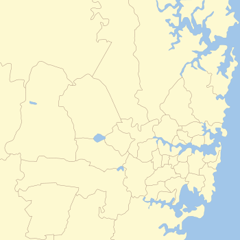
The Hills Shire is a local government area in the Greater Sydney region of Sydney, New South Wales, Australia. The area is north-west of the Sydney central business district, and encompasses 401 square kilometres (155 sq mi) stretching from the M2 Hills Motorway in the south to Wisemans Ferry on the Hawkesbury River in the north. The Hills Shire had a population of 191,876 as of the 2021 census.

<span class="mw-page-title-main">Bella Vista, New South Wales</span> Suburb of Sydney, New South Wales, Australia

Bella Vista is located 33 kilometres north-west of the Sydney central business district and is part of The Hills Shire. It is a suburb in the Hills District of Greater Western Sydney and is in the state of New South Wales, Australia. Bella Vista's Norwest Business Park is home to several Fortune 500 companies, a number of shopping centres, high-rise buildings, and industrial and recreational spaces.

<span class="mw-page-title-main">Baulkham Hills, New South Wales</span> Suburb of The Hills, New South Wales, Australia

Baulkham Hills is a suburb in the Hills District of Greater Sydney, in the state of New South Wales, Australia. It is located within 30 kilometres north-west of the Sydney central business district mostly within the local government area of The Hills Shire, of which Baulkham Hills was formerly the administrative seat and namesake of The Hills Shire. A small section of the suburb which is located south of the Hills Motorway-Windsor Road intersection is part of the City of Parramatta.

<span class="mw-page-title-main">Castle Hill convict rebellion</span> 1804 Australian revolt in New South Wales

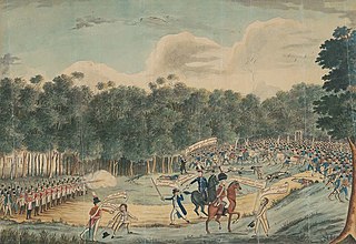
The Castle Hill convict rebellion was an 1804 convict rebellion in the Castle Hill area of Sydney, against the colonial authorities of the British colony of New South Wales. Led by veterans of the United Irish Rebellion of 1798, the poorly armed insurgents confronted the colonial forces of Australia on 5 March 1804 at Rouse Hill. Their rout in the resulting skirmish was hailed by loyalists as Australia's Vinegar Hill after the 1798 Irish Battle of Vinegar Hill, where rebels in Ireland were decisively defeated. The incident was the first major convict uprising in Australian history to be suppressed under martial law.

<span class="mw-page-title-main">Division of Mitchell</span> Australian federal electoral division

The Division of Mitchell is an Australian electoral division in the state of New South Wales.

<span class="mw-page-title-main">Winston Hills, New South Wales</span> Suburb of Sydney, New South Wales, Australia

Winston Hills is a suburb of Sydney, in the state of New South Wales, Australia. Winston Hills is located 28 kilometres west of the Sydney central business district in the local government areas of the City of Parramatta and The Hills Shire. Winston Hills is part of the Hills District region of Greater Western Sydney.

<span class="mw-page-title-main">Kellyville Ridge, New South Wales</span> Suburb of Sydney, New South Wales, Australia

Kellyville Ridge is a suburb of Sydney, in the state of New South Wales, Australia. Kellyville Ridge is located 41 kilometres north-west of the Sydney central business district in the local government area of City of Blacktown. It is part of Greater Western Sydney.

<span class="mw-page-title-main">Rouse Hill, New South Wales</span> Suburb of Sydney, New South Wales, Australia

Rouse Hill is a suburb of Sydney, in the state of New South Wales, Australia. Rouse Hill is located in the Hills District, 43 kilometres north-west of the Sydney central business district and 19 kilometres north-west of the Parramatta central business district. It is in the local government areas of The Hills Shire and City of Blacktown. Rouse Hill Town Centre is at the heart of the suburb, which contains a busy Town Square.

<span class="mw-page-title-main">Kellyville, New South Wales</span> Suburb of Sydney, New South Wales, Australia

Kellyville is a suburb of Sydney, in the state of New South Wales, Australia 36 kilometres north-west of the Sydney central business district in the local government area of The Hills Shire. It is part of the Hills District region.

Beaumont Hills is a suburb of Sydney, in the state of New South Wales, Australia 40 kilometres north west of the Sydney central business district, in the local government area of The Hills Shire. Beaumont Hills is part of the Greater Western Sydney region and the Hills District.

<span class="mw-page-title-main">Norwest Business Park</span>

The Norwest Business Park is a business park in the suburbs of Norwest and Bella Vista in the local government area of The Hills Shire in Sydney, New South Wales, Australia. Norwest Business Park is bordered by Windsor Road to the east, and Old Windsor Road to the west, with Norwest Boulevard stretching the length of the park between the two main arterial roads. Over 400 companies are located in the park, employing more than 25,000 people. The complex consists of a mix of commercial, professional and health-care services provided to the population of Sydney's Hills District.

The North-West T-way is a continuous series of bus-only lanes and bus roadways between Parramatta, Blacktown and Rouse Hill in Western Sydney. Opened in stages between March and November 2007, the 24 km (14.9 mi) T-way was the second bus rapid transit route to be built in Sydney after the Liverpool–Parramatta T-way.

The Rogans Hill railway line was a short-lived railway line in the north-western suburbs of Sydney, Australia.

<span class="mw-page-title-main">Constitution Hill, New South Wales</span> Suburb of Sydney, New South Wales, Australia

Constitution Hill is a suburb of Sydney in the state of New South Wales, Australia. Constitution Hill is located on a hill 28 kilometres (17 mi) west of the Sydney central business district in the local government area of the City of Parramatta and is part of the Western Sydney region. Constitution Hill overlooks the city of Parramatta from above and contains views of the inner Sydney city skyline.

<span class="mw-page-title-main">Regions of Sydney</span> Overview article

The metropolis of Greater Sydney in New South Wales, Australia, is informally subdivided into a number of geographic regions. The geographical definition of Greater Sydney spans across 33 local government areas and includes the Blue Mountains in the west, the Northern Beaches and the Hawkesbury in the north, the Royal National Park, the Wollondilly and Macarthur in the south, and Botany Bay in the east. These areas sometimes, but not always, roughly coincide with official boundaries of suburbs, local government authorities, or cadastral units, and some of the customary regions do not have well defined boundaries at all. Some commonly referred to regions overlap: for example, Canterbury-Bankstown is often referred to as a region, but it is also part of the South Western Sydney region. The regions themselves are not used as a formal jurisdiction, and generally do not have administrative or legislative bodies, although some regions are coterminous with a local government area, and in a number of regions that include multiple local government areas, Regional Organisations of Councils have been established that represent the councils in the region.

<span class="mw-page-title-main">Norwest, New South Wales</span> Suburb of Sydney, New South Wales, Australia

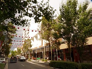
Norwest is a suburb of the Hills District within Greater Western Sydney, in the state of New South Wales, Australia, located 35 kilometres north-west of the Sydney central business district. The Norwest Business Park is located within Norwest and the adjacent suburb of Bella Vista and Baulkham Hills. The council chambers for The Hills Shire Council are also located within this suburb.

North Kellyville is a suburb of Sydney, in the state of New South Wales, Australia. It is located 37 kilometres north-west of the Sydney central business district within the local government area of The Hills Shire. The suburb falls within the Hills District.