Southern Sydney

Last updated

Southern Sydney
New South Wales
Sydneyairportfromabove123.JPG
Sydney Airport, Botany Bay and surrounding suburbs
LGA(s)
State electorate(s) Cronulla, Heathcote, Heffron, Kogarah, Miranda, Oatley, Rockdale
Federal division(s) Banks, Barton, Cook, Hughes, Sydney, Kingsford Smith

Southern Sydney is the southern metropolitan area of Greater Sydney, in the state of New South Wales, Australia.

Contents

Southern Sydney is a title for the regions and neighbourhoods which fall directly south and south-west of the Sydney CBD from the southern boundaries of Central Station down to the Airport and St George region around the southern and western shores of Botany Bay with the southern most concluding point being the Sutherland Shire. This includes all the suburbs in the local government areas of Georges River Council, The Sutherland Shire, most of Bayside Council and the southern suburbs of City of Sydney. [1] The Australian Bureau of Statistics defines a statistical area called The St George-Sutherland Statistical Subdivision [2] and The City and Inner South Statistical Subdivision. [3]

Because the regions that make up Southern Sydney are mostly separated by Botany Bay and The Georges River, rather than directly bordering each other, occasionally suburbs on the eastern shore of Botany Bay are included within Southern Sydney.

The Southern Sydney councils participate in the Southern Sydney Regional Organisation of Councils (SSROC) along with six other councils in the City, Eastern Suburbs and Inner West regions. [4]

The southern suburbs of Sydney can be grouped into three regions:

Inner South

The Inner Southern Suburbs of Sydney, sometimes referred to as 'South Sydney' include the southern suburbs of City of Sydney as well as some of Bayside Council. The area encompasses the suburbs directly south of Central Station or more specifically Cleveland Street leading all the way down to the Airport and fall west of the Eastern Distributor but east of the Alexandra Canal and T3 Train Line. The area starts with Redfern then continues down through Eveleigh, Waterloo, Zetland, Alexandria, Beaconsfield, Rosebery, Eastlakes (West of Eastern Distributor) and ends in Mascot. [5]

The postcodes start at 2015 and end in 2020 with the suburbs of Botany and Banksmeadow being the exception having the postcode of 2019 which while being geographically south of the CBD along with the included suburbs are actually on the other side of the Eastern Distributor usually deeming them Eastern Suburbs that are south-east of CBD rather than part of South Sydney. [6]

The region consists of three train stations being Redfern, Green Square and Mascot as well as one Metro station in Waterloo. [7] Green Square is a locality situated at the meeting point of Alexandria, Zetland, Waterloo, and Beaconsfield. Green Square and Mascot station are on the Airport Link [8] completed in 2000 which is part of the T8 Airport & South Line. Many of these suburbs were predominantly industrial and commercial but have now developed into new residential neighbourhoods of high rise apartments. [9]

The Inner Southern Suburbs are often considered an indefinite region of Sydney [ citation needed ] as it is sometimes considered Inner city or included as part of the Eastern Suburbs that are south-east of CBD however strictly speaking these suburbs geographically are neither east nor south-east of the Sydney CBD.

St George

The St George area, considered the southern suburbs includes all the suburbs in the Georges River Council and the western part of Bayside Council which was Rockdale City prior to 2016. This is everything within the boundaries of Salt Pan Creek to the west, The Georges River to the south, Botany Bay to the east and the M5 Motorway and Wolli Creek to the north. This area corresponds to the southern portion of the cadastral Parish of St George, [10] from which the region derives its name. This southern portion of the parish below the M5 and Wolli Creek is the more contemporary definition of The St George Region that is considered part of Southern Sydney.[ citation needed ]

The northern portion of the Parish of St George that is north of the M5 and Wolli Creek but south of The Cooks River is considered South-Western Sydney rather than Southern Sydney. This northern portion of the cadastral parish was formerly in the City of Canterbury but now within the amalgamated City of Canterbury-Bankstown. In some instances the whole cadastral Parish of St George (both north and south) is grouped together and considered the inner south-west due to its geographical location from Sydney CBD. [11]

Sutherland Shire

The Sutherland Shire is the area to the south of Botany Bay and the Georges River. The Sutherland Shire is 26 kilometres (16 mi) south of Sydney central business district, and is bordered by the City of Canterbury-Bankstown, and Georges River Council local government areas.

The administrative centre of the local government is located in the suburb of Sutherland. [12]

Suburbs in Southern Sydney

Inner South

Localities in the inner south include:

St George

Sutherland Shire Suburbs

Localities administered by the Sutherland Shire are:

Related Research Articles

<span class="mw-page-title-main">Hurstville, New South Wales</span> Suburb of Sydney, New South Wales, Australia

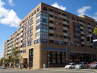
Hurstville is a suburb in Southern Sydney, New South Wales, Australia. It is 16 km (9.9 mi) south of the Sydney CBD and is part of the St George area. Hurstville is the administrative centre of the local government area of the Georges River Council.

<span class="mw-page-title-main">Caringbah</span> Suburb of Sydney, New South Wales, Australia

Caringbah is a suburb in Southern Sydney, in the state of New South Wales, Australia. Caringbah is 24 kilometres (15 mi) south of the Sydney central business district in the local government area of Sutherland Shire.

<span class="mw-page-title-main">Eastern Suburbs & Illawarra Line</span> Rail service in Sydney, New South Wales,Australia

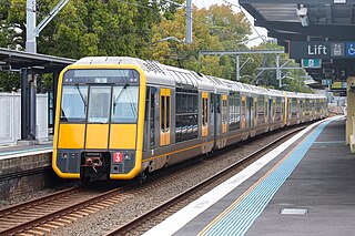
The Eastern Suburbs & Illawarra Line is a commuter railway line on the Sydney Trains network in the eastern and southern suburbs of Sydney. The line was constructed in the 1880s to Wollongong to take advantage of agricultural and mining potentials in the Illawarra area. In March 1926, it became the first railway in New South Wales to run electric train services.

<span class="mw-page-title-main">Eastern Suburbs (Sydney)</span> Region in New South Wales, Australia

The Eastern Suburbs is the eastern metropolitan region of Sydney, New South Wales, Australia.

<span class="mw-page-title-main">Sutherland Shire</span> Local government area in New South Wales, Australia

Sutherland Shire is a local government area in the southern region of Sydney, in the state of New South Wales, Australia. The Sutherland Shire is located just south of the Sydney CBD, and comprises an area of 370 square kilometres (140 sq mi) and as at the 2016 census and has an estimated population of 218,464. The Sutherland Shire is colloquially known as "The Shire" which has been featured in several reality television series.

<span class="mw-page-title-main">Kingsford, New South Wales</span> Suburb of Sydney, New South Wales, Australia

Kingsford is a suburb in the Eastern Suburbs of Sydney, in the state of New South Wales, Australia. Kingsford is located 7 kilometres south-east of the Sydney central business district, in the local government area of the City of Randwick. Kingsford is part of the Eastern Suburbs region.

<span class="mw-page-title-main">St George, Sydney</span> Region in New South Wales, Australia

The St George region of Sydney is part of the southern suburbs of Sydney, in the state of New South Wales, Australia. The area includes all the suburbs in the local government area of Georges River Council and the part of Bayside Council which was Rockdale City prior to 2016. This is everything within the boundaries of Salt Pan Creek to the west, The Georges River to the south, Botany Bay to the east and the M5 Motorway and Wolli Creek to the north. This area corresponds to the southern portion of the cadastral Parish of St George, from which the region derives its name and the area was later covered by the St George County Council, the electricity supplier for the councils in this region. This southern portion of the parish below The M5 and Wolli Creek is the more contemporary definition of The St George Region that is considered part of Southern Sydney.

<span class="mw-page-title-main">Rockdale, New South Wales</span> Suburb of Sydney, New South Wales, Australia

Rockdale is a suburb in southern Sydney, in the state of New South Wales, Australia. Rockdale is located 13 kilometres south of the Sydney central business district and is part of the St George area. Rockdale is one of the administrative centres for the local government area of the Bayside Council. Since 1985 Rockdale has been a twinned city with Bitola, in the Republic of Macedonia.

<span class="mw-page-title-main">Wolli Creek, New South Wales</span> Suburb of Sydney, New South Wales, Australia

Wolli Creek is a suburb in southern Sydney, in the state of New South Wales, Australia. It sits beside the Wolli Creek and Cooks River waterways. Wolli Creek is situated between the suburbs of Arncliffe and Tempe, 10 kilometres south of the Sydney central business district and is part of the St George area. Wolli Creek is in the local government area of Bayside Council.

<span class="mw-page-title-main">Burraneer, New South Wales</span> Suburb of Sydney, New South Wales, Australia

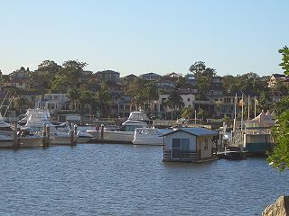
Burraneer is a bayside suburb in southern Sydney, in the state of New South Wales, Australia. Burraneer is 26 kilometres south of the Sydney central business district, in the local government area of the Sutherland Shire.

<span class="mw-page-title-main">Bardwell Park, New South Wales</span> Suburb of Sydney, New South Wales, Australia

Bardwell Park is a suburb in southern Sydney, in the state of New South Wales, Australia. The suburb is located 12 kilometres south-west of the Sydney central business district and is part of the St George area. Bardwell Park is in the local government area of the Bayside Council. Bardwell Valley is a separate suburb, to the east.

<span class="mw-page-title-main">Blakehurst, New South Wales</span> Suburb of Sydney, New South Wales, Australia

Blakehurst is a suburb in southern Sydney, in the state of New South Wales, Australia 18 kilometres south of the Sydney central business district, in the local government area of the Georges River Council. It is part of the St George area.

The Sydney Roosters Juniors are officially known as the Eastern Suburbs District Junior Rugby League. It is an affiliation of junior clubs in the Eastern Suburbs area, covering the Woollahra and Waverley local government areas (LGAs), the northern parts of the Randwick LGA and the City of Sydney LGA, in Sydney, Australia.

<span class="mw-page-title-main">Parish of St George</span> Cadastral in New South Wales, Australia

St George Parish is one of the 57 parishes of Cumberland County, New South Wales, a cadastral unit for use on land titles. It is bounded in the north by the Cooks River, in the west by Cox's Creek and Salt Pan Creek, and in the south by the Georges River and in the east by Botany Bay.

<span class="mw-page-title-main">Hundred of Sydney</span> Cadastral in New South Wales, Australia

The Hundred of Sydney is a former lands administrative division for the city of Sydney and its inner suburbs. It was one of the thirteen hundreds in the County of Cumberland, which were published in the government gazette of May 27, 1835, and repealed on January 21, 1888.

<span class="mw-page-title-main">Regions of Sydney</span> Overview article

The metropolis of Greater Sydney in New South Wales, Australia, is informally subdivided into a number of geographic regions. The geographical definition of Greater Sydney spans across 33 local government areas and includes the Blue Mountains in the west, the Northern Beaches and the Hawkesbury in the north, the Royal National Park, the Wollondilly and Macarthur in the south, and Botany Bay in the east. These areas sometimes, but not always, roughly coincide with official boundaries of suburbs, local government authorities, or cadastral units, and some of the customary regions do not have well defined boundaries at all. Some commonly referred to regions overlap: for example, Canterbury-Bankstown is often referred to as a region, but it is also part of the South Western Sydney region. The regions themselves are not used as a formal jurisdiction, and generally do not have administrative or legislative bodies, although some regions are coterminous with a local government area, and in a number of regions that include multiple local government areas, Regional Organisations of Councils have been established that represent the councils in the region.

<span class="mw-page-title-main">Metrobus (Sydney)</span> Sydney high frequency, high capacity bus network

Metrobus is a high frequency, high capacity bus network in Sydney, Australia, first introduced in 2008. Metrobus services run every 10 minutes during peak periods, 15 minutes during off-peak weekday periods, and 20 minutes on weekends, linking key commercial suburbs and centres throughout the city, with the intention of making timetables obsolete. All buses were initially painted in a distinctive red livery but recently, the standard Transport for NSW livery of blue and white has been adopted. All Metrobus services are wheelchair accessible. All route numbers were prefixed with an "M" followed by a two-digit number.

<span class="mw-page-title-main">Georges River Council</span> Local government area in New South Wales, Australia

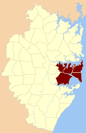
Georges River Council is a local government area located in the St George region of Sydney located south of the Sydney CBD, in New South Wales, Australia. The Council was formed on 12 May 2016 from the merger of the Hurstville City Council and Kogarah City Council.

<span class="mw-page-title-main">Bayside Council</span> Local government area in New South Wales, Australia

Bayside Council is a local government area in Sydney, New South Wales, Australia. It is located around part of Botany Bay, 7 kilometres (4.3 mi) to 12 kilometres (7.5 mi) south of the Sydney CBD. It includes suburbs of Southern Sydney as well as a small portion in the Eastern suburbs, south-east of the Sydney CBD. It comprises an area of 50 square kilometres (19 sq mi) and as at the 2016 census had a population of 156,058.

References

  1. "Home | City of Sydney | Community profile".
  2. National Regional Profile : St George-Sutherland (Statistical Subdivision)
  3. "2021 Sydney - City and Inner South, Census All persons QuickStats | Australian Bureau of Statistics".
  4. SSROC - Member Councils
  5. "2021 Sydney - City and Inner South, Census All persons QuickStats | Australian Bureau of Statistics".
  6. "2021 Botany Bay, Census Aboriginal and/Or Torres Strait Islander people QuickStats | Australian Bureau of Statistics".
  7. "Waterloo Station | Sydney Metro".
  8. https://airportlink.com.au/
  9. "Green Square". 4 March 2022.
  10. "Parish of St. George, County of Cumberland [cartographic material] : Metropolitan Land District, Eastern Division N.S.W."
  11. "2021 Sydney - Inner South West, Census All persons QuickStats | Australian Bureau of Statistics".
  12. "Contact us". 21 July 2022.