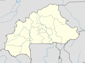
Burkina Faso is a landlocked country in West Africa with an area of 274,200 km2 (105,900 sq mi), bordered by Mali to the northwest, Niger to the northeast, Benin to the southeast, Togo and Ghana to the south, and the Ivory Coast to the southwest. It has a population of 20,321,378. Previously called Republic of Upper Volta (1958–1984), it was renamed Burkina Faso by President Thomas Sankara. Its citizens are known as Burkinabès, and its capital and largest city is Ouagadougou.

Burkina Faso is a landlocked Sahel country that shares borders with six nations. It lies between the Sahara desert and the Gulf of Guinea, south of the loop of the Niger River, mostly between latitudes 9° and 15°N, and longitudes 6°W and 3°E. The land is green in the south, with forests and fruit trees, and semi-arid in the north. Most of central Burkina Faso lies on a savanna plateau, 198–305 metres (650–1,001 ft) above sea level, with fields, brush, and scattered trees. Burkina Faso's game preserves – the most important of which are Arly, Nazinga, and W National Park—contain lions, elephants, hippopotamus, monkeys, common warthogs, and antelopes. Previously the endangered painted hunting dog, Lycaon pictus occurred in Burkina Faso, but, although the last sightings were made in Arli National Park, the species is considered extirpated from Burkina Faso.

Ouagadougou is the capital and largest city of Burkina Faso and the administrative, communications, cultural, and economic centre of the nation. It is also the country's largest city, with a population of 2,415,266 in 2019. The city's name is often shortened to Ouaga. The inhabitants are called ouagalais. The spelling of the name Ouagadougou is derived from the French orthography common in former French African colonies.

The regions of Burkina Faso are divided into 45 administrative provinces. These 45 provinces are currently sub-divided into 351 departments or communes.
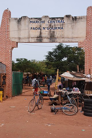
Fada N'gourma, also written Fada-Ngourma or Noungu, is a city and an important market town in eastern Burkina Faso, lying 219 kilometres (136 mi) east of Ouagadougou, in the Gourmantché area. It is the capital of the East region and of Gourma province. It is known for its blanket and carpet manufacturing as well as its honey.

Ouahigouya is a town in northern Burkina Faso. It is the capital of the Yatenga Province and one of its subdivisions the Ouahigouya Department. It is also the biggest town in the Nord Region. It is the fourth largest city in the country with a population of 124,587 (2019) and is situated 182 kilometres (113 mi) north-west of Ouagadougou.
Diébougou is a town in Burkina Faso, situated 136 kilometres (85 mi) south-east of Bobo-Dioulasso on the main highway to Ghana. It is located 74 kilometres north of Gaoua and 133 km west of Leo, Burkina Faso and is the capital of Bougouriba Province.
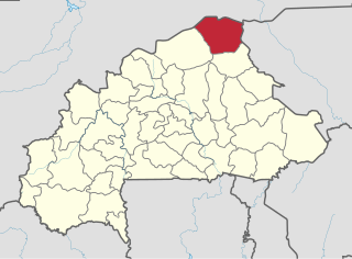
Oudalan is one of the 45 provinces of Burkina Faso, located in its Sahel Region. Its capital is Gorom-Gorom. The 2019 census reported 158,146 people living in the province.

Dori is a town in northeastern Burkina Faso, near the border of Niger. It is located at around 14.03°N 0.03°W. It is the capital of Sahel Region and has a population of 46,512 (2019). The main ethnic group is the Fula (Fulani) but Tuaregs, Songhai, and Hausa people are often present. It is a town known for its herders and popular livestock markets.
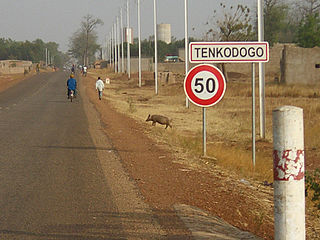
Tenkodogo is the capital city of Boulgou Province and the Centre-Est Region of Burkina Faso with a population of 61,936 (2019).

According to the Government of Burkina Faso, 433,778 tourists visited the country in 2011.
Articles related to Burkina Faso include:

Coalla is a department or commune of Gnagna Province in northern Burkina Faso. Its capital lies at the town of Coalla. It has an area of 1,957 km2.

Téra is a department of the Tillabéri Region in Niger. Its capital lies at the city of Téra. As of 2011, the department had a total population of 579,658 people.

Gorom-Gorom is a department or commune of Oudalan Province in northern Burkina Faso. Its capital is the town of Gorom-Gorom.
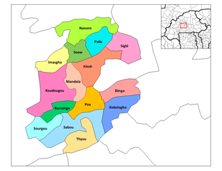
Ramongo is a department or commune of Boulkiemdé Province in central Burkina Faso. As of 2005 it has a population of 28,326. Its capital lies at the town of Ramongo.
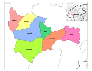
Founzan is a department or commune of Tuy Province in southern Burkina Faso. Its capital lies at the town of Founzan.
Béguédo is a town and seat of the Béguédo Department of Boulgou Province in south-eastern Burkina Faso. It is located on the highway route N17. As of 2019, the town has a population of 21,894. One of the six branches of the Banque Atlantique in Burkina Faso is located in Béguédo.
Loaba is a town in the Bittou Department of Boulgou Province in south-eastern Burkina Faso. As of 2005, the town has a population of 3,518.