
The Sesia is a river in Piedmont, north-western Italy, tributary to the Po.

The Province of Rieti is a province in the Lazio region of Italy. Its capital is the city of Rieti. Established in 1927, it has an area of 2,750.52 square kilometres (1,061.98 sq mi) with a total population of 157,887 people as of 2017. There are 73 comuni in the province.

Monte Rosa is a mountain massif in the eastern part of the Pennine Alps, on the border between Italy and Switzerland (Valais). The highest peak of the massif, amongst several peaks of over 4.000 m, is the Dufourspitze, the second highest mountain in the Alps and western Europe, after Mont Blanc. The east face of the Monte Rosa towards Italy has a height of about 2.400 meters and is the highest mountain wall of the Alps.

The Panaro is an Italian river and the final right-hand tributary to the Po, discounting the Cavo Napoleonico canal. It runs right across Emilia-Romagna in a north-easterly direction: from its source close to the Apennine watershed, where Emilia-Romagna meets Tuscany, to its outlet where the Po marks the region's boundary with Veneto. Its Latin name was Scultenna.

The Tanaro, is a 276-kilometre (171 mi) long river in northwestern Italy. The river begins in the Ligurian Alps, near the border with France, and is the most significant right-side tributary to the Po in terms of length, size of drainage basin, and discharge.

The Arda is a torrent of Emilia-Romagna, Italy, nearly all of its course being within the province of Piacenza. It is a right tributary of the Po River.
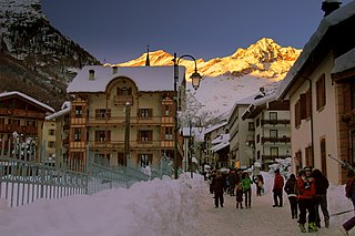
Alagna Valsesia is a comune and small village high in the Valsesia alpine valley in the province of Vercelli, Piedmont, northern Italy, a UNESCO World heritage site since 2013. It is a tourist place for mountaineering and winter sports, and it is internationally renowned for the freeride off-piste skiing. It is also the traditional starting point for the Margherita Hut climb, at 4,554 metres (14,941 ft) above sea level, the highest building in Europe. It was originally settled by Walser at the beginning of the 12th century. It is located at an elevation of 1,191 metres (3,907 ft) just south of the Monte Rosa, elevation 4,638 metres (15,217 ft) ; It is very close to Milan and to the international Milan–Malpensa Airport.

The Taro is a river in Emilia-Romagna, in northern Italy. It is a tributary of the Po and is 126 kilometres (78 mi) long. It flows almost entirely in the province of Parma, west of the city Parma. The Taro flows into the Po near Gramignazzo, a frazione of the comune of Sissa, north of Parma.

Bosio is a comune (municipality) in the Province of Alessandria in the Italian region Piedmont, located about 100 kilometres (62 mi) southeast of Turin and about 35 kilometres (22 mi) southeast of Alessandria.
The Staffora is a river of the Oltrepò Pavese in the Province of Pavia, north-west Italy and a right-side tributary of the Po. It is probably the river known to the Romans as the Iria.
The Orba is a torrent of northern Italy.

The Rotaldo, known in its upper course as the Laio, is a 40-kilometre (25 mi) river of northern Italy, and a right-side tributary of the Po River. Most of its course falls within the Province of Alessandria and all of it within the former Province of Casale. The river is of modest flow and is heavily reliant on rainfall with a discharge near its mouth of 1.6 cubic metres per second (57 cu ft/s).

The Elvo is a 53-kilometre (33 mi) torrent in the Piedmont region of north-west Italy and is the principal tributary of the Cervo. It runs through the communes of Sordevolo, Occhieppo Superiore, Occhieppo Inferiore, Cerrione and Salussola in the Province of Biella, and of Carisio and Casanova Elvo in the Province of Vercelli.

The Stura del Monferrato is a 36.7-kilometre (22.8 mi) stream, which runs through Murisengo, Cerrina Monferrato, Mombello Monferrato and Pontestura in the Italian Province of Alessandria.

Lago di Malciaussia is a reservoir situated at an elevation of 1,805 metres in the upper Valle di Viù in the north-west Italian province of Turin.
The Val di Chiana, Valdichiana, or Chiana Valley, formerly Clanis Valley, is a tectonic valley of central Italy, whose valley floor consists of important alluvial residues filled up since the 11th century, lying on the territories of the provinces of Arezzo and Siena in Tuscany and the provinces of Perugia and Terni in Umbria.
Laghi del Gorzente is a group of three lakes in north-west Italy which straddles the provinces of Genoa and Alessandria.

The Erro is a 46-kilometre (29 mi) torrent of north-west Italy, a right tributary of the Bormida.
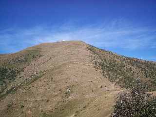
Monte Tobbio is a 1092 metres high mountain of the Apennines, located in the Italian region of Piedmont.

