
The Dakar–Niger Railway connects Dakar, Senegal to Koulikoro, Mali. The name refers to the Niger River, not the Republic of Niger. It serves many cities in Senegal, including Thiès, and in Mali, including Kayes, Kita, Kati, Bamako. The line covers a course of 1,287 km of which 641 km lies in Mali.

Kaffrine is the capital town of Kaffrine Region of Senegal.
Koziatyn is a city in the Vinnytsia Oblast (province) in central Ukraine. It served as the administrative center of the Koziatyn Raion (district); the city itself was not a part of the district and is separately incorporated as the city of regional significance, and is located 75 kilometres (47 mi) from the oblast capital, Vinnytsia, at around 49°43′00″N28°50′00″E. It is now part of the Khmilnyk Raion since 2020. It lies on the banks of the Huyva River. Population: 22,241.

Sélibaby is a capital town and department of the Guidimaka Region, in Mauritania. It is located at around 15°9′33″N12°11′00″W. It is divided into a number of "quartiers" which include "College", "Silo", 'Ferlo", "Nezaha", "Saada", "El Jedidah" "Bambaradougou" amongst many others.

The Gwa'Sala-Nakwaxda'xw Nations are a union of two Kwakwaka'wakw peoples in a band government based on northern Vancouver Island in British Columbia, Canada, whose main reserve community is near the town of Port Hardy in the Queen Charlotte Strait region of the Central Coast region of British Columbia, Canada. The band government is a member of the Kwakiutl District Council and, for treaty negotiation purposes, the Winalagalis Treaty Group which includes three other members of the Kwakiutl District Council.
The Lytton First Nation, a First Nations band government, has its headquarters at Lytton in the Fraser Canyon region of the Canadian province of British Columbia. While it is the largest of all Nlaka'pamux bands, unlike all other governments of the Nlaka'pamux (Thompson) people, it is not a member of any of the three Nlaka'pamux tribal councils, which are the Nicola Tribal Association, the Fraser Canyon Indian Administration and the Nlaka'pamux Nation Tribal Council.

Diourbel Department is one of the 45 departments of Senegal, one of the three constituting the Diourbel Region.
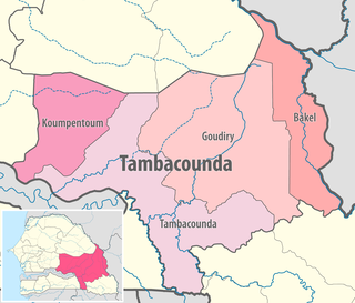
Bakel Department is one of the 45 departments of Senegal and one of the four making up the Tambacounda Region in the east of the country. The department had an area of 22,378 km² and population estimate at 215,680 in 2005. However, in 2008 the department was split to form the new department of Goudiry, so the area was reduced to estimated 6,290 km².
Castelverde, also named Gasr Garabulli, is a town in the Tripoli District (Tarabulus), of the Tripolitania region in northwestern Libya.

Talaimannar is a settlement in Sri Lanka located on the northwestern coast of Mannar Island.
Gossas is a town in Fatick Region in western Senegal, about 90 km from the capital.
Mederdra is a small town and commune in south-west Mauritania, near the border of Senegal.
Bargny is a settlement in Senegal. It is located in a somewhat sheltered bay about 15 km to the east of the capital, Dakar.
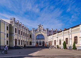
Railway stations in Mali include:
Goudiry Department is one of the 45 departments of Senegal, one of four making up the Tambacounda Region. It was created by decree in 2008.
Borchotto is a town in central Ethiopia.
Naye is a town in Senegal on the border with Mali
Lydiane is a town in east central Senegal in Kaolack region.
Dunblane is a ghost town in the Canadian province of Saskatchewan.

Tourcoing station is a railway station serving the town Tourcoing, Nord department, northern France.
