| Gourma-Rharous Cercle | |
|---|---|
| Cercle | |
 | |
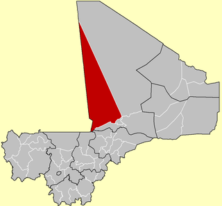
 Location of the Cercle of Gourma-Rharous in Mali | |
| Country | |
| Region | Tombouctou Region |
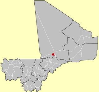
| Admin HQ ( Chef-lieu ) | Gourma-Rharous |
| Area [1] | |
| • Total | 45,000 km2 (17,000 sq mi) |
| Population (2009 census) [2] | |
| • Total | 111,386 |
| • Density | 2.5/km2 (6.4/sq mi) |
| Time zone | GMT (UTC+0) |

Gourma-Rharous Cercle is an administrative subdivision of the Tombouctou Region of Mali. The administrative center is the town of Gourma-Rharous.

Tombouctou Region is one of the administrative regions of Mali. It is the largest of Mali's eight regions and includes a large section of the Sahara Desert. For administrative purposes, the region is subdivided into five cercles.

Mali, officially the Republic of Mali, is a landlocked country in West Africa, a region geologically identified with the West African Craton. Mali is the eighth-largest country in Africa, with an area of just over 1,240,000 square kilometres (480,000 sq mi). The population of Mali is 18 million. Its capital is Bamako. The sovereign state of Mali consists of eight regions and its borders on the north reach deep into the middle of the Sahara Desert, while the country's southern part, where the majority of inhabitants live, features the Niger and Senegal rivers. The country's economy centers on agriculture and mining. Some of Mali's prominent natural resources include gold, being the third largest producer of gold in the African continent, and salt.

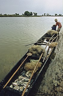
Gourma-Rharous is a rural commune and small town in the Tombouctou Region of Mali. The town is the administrative center (Chef-lieu) of the Gourma-Rharous Cercle and lies on the right bank of the Niger River 110 km east of Timbuktu. The commune has an area of approximately 7,000 km2 and contains 29 villages. In the census of 2009 it had a population of 26,115. French singer Daniel Balavoine died in a helicopter crash in Gourma-Rharous as he was leading a fund-raising effort in Africa during the 1986 Dakar Rally.
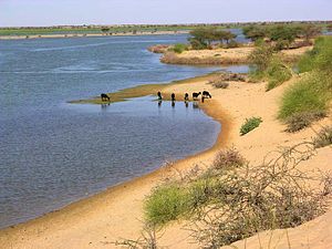
The route of the annual circular migration of the Gourma elephants crosses a number of communes in the cercles of Gourma-Rharous and Douentza (Mopti Region). Lake Banzena ( 15°40′00″N2°35′30″W / 15.66667°N 2.59167°W ) in the commune of Bambara Maoudé serves as an important source of water for the elephants at the end of the dry season (April to June). [3] [4] [5]

Douentza Cercle is an administrative subdivision of the Mopti Region of Mali. The administrative center (chef-lieu) is the town of Douentza.

Mopti is the fifth administrative region of Mali, covering 79,017 km2. Its capital is the city of Mopti. During the 2012 Northern Mali conflict, the frontier between Southern Mali which is controlled by the central government and the rebel-held North ran through Mopti Region.

Bambara Maoudé or Bambara Maoundé is a village and rural commune of the Cercle of Gourma-Rharous in the Tombouctou Region of Mali. The commune contains 44 villages and had a population of 16,874 in the 2009 census.
The cercle is divided into nine communes: [6] [7]
Banikane is a village and commune of the Cercle of Gourma-Rharous in the Tombouctou Region of Mali. The village lies on the right bank of the River Niger, 25 km downstream of Rharous. The commune extends on both banks of the river and includes 15 villages. In the 2009 census the population of the commune was 9,433.
Gossi is a town and rural commune in the Cercle of Gourma-Rharous of the Tombouctou Region of Mali, lying northeast of Hombori and southwest of Gao. The town is just to the west of the main RN15 highway that links Mopti with Gao. It is on a seasonal lake, Mare de Gossi, and is surrounded by nature reserves in which a large herd of elephants live. The town is the site of a large cattle market. The commune contains around 31 villages and in the 2009 census, it had a population of 24,521. Most of the population are nomadic pastoralists but there are permanent settlements around Lake Gossi, Lake Ebanguemalène and Lake Agoufou.
Hanzakoma or Hamzakoma is a rural commune of the Cercle of Gourma-Rharous in the Tombouctou Region of Mali. The commune contains 19 villages and in the 2009 census had a population of 7,929. The principal village (chef-lieu) is Minkiri.