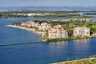
Fisher Island is a census-designated place in Miami-Dade County, Florida, United States, located on a barrier island of the same name. Since 2015, Fisher Island has the highest per capita income of any place in the United States. It had only 218 households and a total population of 467.
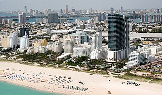
Miami Beach is a coastal resort city in Miami-Dade County, Florida. It was incorporated on March 26, 1915. The municipality is located on natural and man-made barrier islands between the Atlantic Ocean and Biscayne Bay, the latter of which separates the Beach from the mainland city of Miami. The neighborhood of South Beach, comprising the southernmost 2.5 sq mi (6.5 km2) of Miami Beach, along with Downtown Miami and the PortMiami, collectively form the commercial center of South Florida. Miami Beach's population is 82,890 according to the 2020 census. Miami Beach is the 26th largest city in Florida based on official 2019 estimates from the U.S. Census Bureau. It has been one of America's pre-eminent beach resorts since the early 20th century.
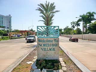
North Bay Village is a city located in Miami-Dade County, Florida. As of the 2020 census, the city had a total population of 8,159.

Biscayne Bay is a lagoon with characteristics of an estuary located on the Atlantic coast of South Florida. The northern end of the lagoon is surrounded by the densely developed heart of the Miami metropolitan area while the southern end is largely undeveloped with a large portion of the lagoon included in Biscayne National Park.
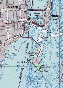
Key Biscayne is an island located in Miami-Dade County, Florida, located between the Atlantic Ocean and Biscayne Bay. It is the southernmost of the barrier islands along the Atlantic coast of Florida, and lies south of Miami Beach and southeast of Miami. The key is connected to Miami via the Rickenbacker Causeway, originally built in 1947.

The Miami River is a river in the United States state of Florida that drains out of the Everglades and runs through the city of Miami, including Downtown. The 5.5-mile (8.9 km) long river flows from the terminus of the Miami Canal at Miami International Airport to Biscayne Bay. It was originally a natural river inhabited at its mouth by the Tequesta Indians, but it was dredged and is now polluted throughout its route through Miami-Dade County. The mouth of the river is home to the Port of Miami and many other businesses whose pressure to maintain it has helped to improve the river's condition.

The Miami metropolitan area is the ninth largest metropolitan statistical area in the United States and the 34th largest metropolitan area in the world with a 2020 population of 6.138 million people.

Virginia Key is an 863-acre (3.49 km2) barrier island in Miami, Florida. It is located in Biscayne Bay south of Brickell and north of Key Biscayne and is accessible from the mainland via the Rickenbacker Causeway.

The Venetian Causeway crosses Biscayne Bay between Miami on the mainland and Miami Beach on a barrier island in the Miami metropolitan area. The man-made Venetian Islands and non-bridge portions of the causeway were created by materials which came from the dredging of the bay. The Venetian Causeway follows the original route of the Collins Bridge, a wooden 2.5 mi (4 km) long structure built in 1913 by John S. Collins and Carl G. Fisher which opened up the barrier island for unprecedented growth and development.
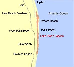
The Lake Worth Lagoon is a lagoon located in Palm Beach County, Florida. It runs parallel to the coast, and is separated from the Atlantic Ocean by barrier beaches, including Palm Beach Island. The lagoon is connected to the Atlantic Ocean by two permanent, man-made inlets.
The General Douglas MacArthur Causeway is a six-lane causeway that connectsDowntown Miami to South Beach via Biscayne Bay in Miami-Dade County.

The Rickenbacker Causeway is a causeway that connects Miami, Florida to the barrier islands of Virginia Key and Key Biscayne across Biscayne Bay.
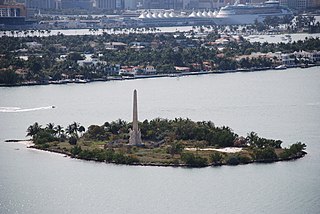
Flagler Memorial Island is an uninhabited artificial island of South Beach in the city of Miami Beach in Biscayne Bay, Florida. A 110-foot (34 m) high obelisk with allegorical sculptures at its base stands as a monument to Miami pioneer Henry M. Flagler, and was built in the center of the freshly constructed island in memory of Flagler, who died in 1913.

Crandon Park is an 808-acre (3.27 km2) urban park in metropolitan Miami, occupying the northern part of Key Biscayne. It is connected to mainland Miami via the Rickenbacker Causeway.

The Port of Miami Tunnel is a 4,200-foot (1,300 m) bored, undersea tunnel in Miami, Florida. It consists of two parallel tunnels that travel beneath Biscayne Bay, connecting the MacArthur Causeway on Watson Island with PortMiami on Dodge Island. It was built in a public–private partnership between three government entities—the Florida Department of Transportation, Miami-Dade County, and the City of Miami—and the private entity MAT Concessionaire LLC, which was in charge of designing, building, and financing the project and holds a 30-year concession to operate the tunnel.

Hibiscus Island is a neighborhood in the city of Miami Beach on a man-made island in Biscayne Bay, Florida, United States. Hibiscus Island lies just north of Palm Island. It is an exclusive residential neighborhood with relatively high property values. The island is accessible via the MacArthur Causeway.
Isle of Normandy or Normandy Island or Normandy Isles or Normandy Isle is a neighborhood of North Beach in the city of Miami Beach, Florida. It is located along the eastern shore of Biscayne Bay.

South Pointe Park, known locally as South Pointe, is a 17-acre (6.9 ha) county urban park in metropolitan Miami, in the South Beach neighborhood of Miami Beach, Florida.

José Delfín Fernández Gómez was a Cuban-American professional baseball pitcher who played four seasons in Major League Baseball (MLB). He was a member of the Miami Marlins from 2013 until his death in 2016. He stood 6 feet 3 inches (1.91 m) tall and weighed 243 pounds (110 kg) during his playing career. He was affectionately known as "Niño" to his teammates and fans due to the youthful exuberance with which he played the game.
Sandspur Island is the largest spoil island in Biscayne Bay, which is part of the Oleta River State Park in Southern Florida. The island is 15 acres (6.1 ha), the largest island in North Bay of the Biscayne Bay and only accessible by boat.

