Grand Canal Dock

Last updated

The west inner basin and Boland's Mill, January 2022 Boland's Quay, Silicon Docks.jpg
The west inner basin and Boland's Mill, January 2022
View of the western (inner) basin from the top floor of the Google Docks (Montevetro) building. Boland's Mill, the Alto Vetro building, and The Marker Hotel can be seen. Dublin Grand Canal Basin.jpg
View of the western (inner) basin from the top floor of the Google Docks (Montevetro) building. Boland's Mill, the Alto Vetro building, and The Marker Hotel can be seen.

Grand Canal Dock (Irish : Duga na Canálach Móire) is a Southside area near the city centre of Dublin, Ireland. It is located on the border of eastern Dublin 2 and the westernmost part of Ringsend in Dublin 4, surrounding the Grand Canal Docks, an enclosed harbour where the Grand Canal comes to the River Liffey. The area has undergone significant redevelopment since 2000, as part of the Dublin Docklands area redevelopment project.

Contents

The area has been nicknamed "Silicon Docks" [1] [2] [3] by Google and Facebook (a reference to Silicon Valley) as it has become a popular location for multinational technology firms such as Google, [4] Facebook, [5] Twitter, [6] LinkedIn, [7] and Airbnb. [8] The area has been the subject of debate over the balance of development and gentrification as well as the subject of derision over the clichéd nature of its new nickname. [9]

Location

There is no precise definition of the Grand Canal Dock area, but it is generally understood to be bounded by the Liffey to the north, South Lotts Road to the east (or Barrow Street if separating South Lotts as its own area), Grand Canal Street to the south, and Macken Street to the west (although some maps show the area including as far west as the corner of Leeson Street and Fitzwilliam Place). Grand Canal Dock contains Grand Canal Dock railway station and the national Waterways Ireland Visitor Centre.[ citation needed ]

Access

Grand Canal Dock railway station, accessed from Barrow Street, opened in 2001 (although the line has been in use since 1834). In early 2014, five new Dublin Bikes stations were opened in the area.

History

Opening of the Ringsend Docks, Dublin, 23 April 1796. Opening of the Ringsend Docks, Dublin, 23 April 1796 .PNG
Opening of the Ringsend Docks, Dublin, 23 April 1796.

The Grand Canal Docks first opened in 1796, built to a design by William Jessop. [10] Before this development, in medieval times, the area was associated with lepers, as recorded in some of the street names such as Misery Hill and Lazer Lane. [11] At the time, they were the world's largest docks. They fell into decline within just a few decades, due mostly to reduced canal usage with the arrival of the railways. The landscape was dominated by Dublin Gas Company's mountains of black coal, along with chemical factories, tar pits, bottle factories, and iron foundries. However, bakers and millers maintained business along the southern edge of the inner basin. [12] By the 1960s, the Grand Canal Docks were almost completely derelict.

Around 1987, it was decided that Hanover Quay was too toxic to sell. Regeneration began in 1998, when Bord Gáis sold the Dublin Docklands Development Authority (DDDA) the former gasworks site located in the area between Sir John Rogerson's Quay and Hanover Quay, for €19 million. The DDDA spent €52 million decontaminating the land, even though the likely return was estimated at just €40 million. The decontamination took place under the supervision of the Environmental Protection Agency, between 2002 and 2006. The process involved constructing an underground wall eight metres deep around the affected area, and the contaminated soil was dug out and removed. By the time the decontamination was finished, an inflated property bubble and increased demand in the area (brought on, in part, by the decision by Google to set up its European headquarters nearby) allowed the authority to sell the land for €300 million. The DDDA injected some of its new funds into the area's infrastructure, including seats, street lighting, and civic spaces. [13]

A number of buildings have since been developed, involving the construction of millions of euros worth of real estate, the establishment of what is now sometimes known as Silicon Docks, and the arrival of several thousand new residents.[ citation needed ]

Sites control and planning

On 22 May 2014, it was announced that a fast-track planning process was approved by An Bord Pleanala, with 366,000 square metres of office space and 2,600 homes to be developed across 22 hectares of land in the North Lotts and Grand Canal Dock areas under the Docklands Strategic Development Zone (SDZ) planning scheme. [14] A number of site plan notices have been posted in the area, including the following:

Buildings

Several of the buildings surrounding Grand Canal Square, such as the Bord Gáis Energy Theatre, The Marker Hotel, and the HQ office development, were designed by McCauley Daye O’Connell Architects. [16] Notable features of the Grand Canal Dock area include:

Grand Canal Square

The front of the Daniel Libeskind designed Bord Gais Energy Theatre pictured from the Martha Schwartz Partners designed Grand Canal Square Bord Gais Energy Theatre (8225077260).jpg
The front of the Daniel Libeskind designed Bord Gáis Energy Theatre pictured from the Martha Schwartz Partners designed Grand Canal Square

Grand Canal Square Square was completed in 2008. The €8 million plaza consists of red resin-glass paving that juts out into the water, dotted with illuminated red poles. Planted sections are arranged diagonally across the square.

Alto Vetro (2008), and the National Waterways Visitor Centre Alto Vetro.jpg
Alto Vetro (2008), and the National Waterways Visitor Centre

Alto Vetro

The Alto Vetro apartment building was awarded the Royal Institute of the Architects of Ireland’s (RIAI) Silver Medal for Housing (2007-2008). [17] It was built by the Montevetro developers Treasury Holdings.

Boland's Mill

Boland's Mill was a functioning mill until 2001, after which the site, including older stone buildings and taller concrete silos, became derelict. As of February 2019, the site was undergoing a €150 million reconstruction to become Bolands Quay, accommodating new residences, commercial, retail, and civic spaces. [18]

View of the Google Docks (Montevetro) building from the roof of The Marker Hotel Google Docks Building Dublin.jpg
View of the Google Docks (Montevetro) building from the roof of The Marker Hotel
The outer basin with Millennium Tower (1998) IMG MilleniumTowerGCD5615w.jpg
The outer basin with Millennium Tower (1998)

Bord Gáis Energy Theatre

The Bord Gáis Energy Theatre is the largest theatre in Ireland. It was designed by Polish-American architect Daniel Liebeskind. It was opened as the Grand Canal Theatre in 2010 but renamed in March 2012 as part of a paid naming rights agreement. [19]

The Factory

The Factory houses Irish Film and Television Network studios, as well as rehearsal and recording studios where a number of U2's albums were recorded.

Google Docks

The Montevetro building completed in 2010 stands at a height of 67 metres and is one of the tallest commercial building in Dublin. It was sold to Google in January 2011 and subsequently renamed "Google Docks". [4] In 2014, the Google Docks building was joined by an "iconic" curving three-pronged steel and transparent glass footbridge to Google's two office buildings across Barrow Street - Gordon House and Gasworks House. It has been named "Hyperlink". [20] [21]

The Marker Hotel

The Marker Hotel is owned by development firm Tetrarch Capital and is one of only six of The Leading Hotels of the World in Ireland. It was designed in 2004 by Portuguese architect Manuel Aires Mateus. It opened in 2013 and offers the city's first rooftop terrace and bar. [16]

Millennium Tower

Millennium Tower is an apartment building located on the Grand Canal outer basin. At 63 metres in height, it was the tallest storied building in Dublin from 1998 - 2009.

No. 2, 4, and 5 Grand Canal Square

The modern office buildings alongside the Bord Gáis Energy Theatre were designed by architect Daniel Liebeskind and developed by Chartered Land. No 2 houses offices for Capita Asset Services & William Fry Solicitors. No 4 houses offices for Facebook's European headquarters. [2]

Related Research Articles

<span class="mw-page-title-main">Ringsend</span> Suburb of Dublin, Ireland

Ringsend is a southside inner suburb of Dublin, Ireland. It is located on the south bank of the River Liffey and east of the River Dodder, about two kilometres east of the city centre. It is the southern terminus of the East Link Toll Bridge. Areas included in Ringsend are the south side of the Dublin Docklands, and at the west end is the area of South Lotts and part of the Grand Canal Dock area. Neighbouring areas include Irishtown, Sandymount and the Beggars Bush part of Ballsbridge to the south, and the city centre to the west. A key feature of the area is the chimneys of Poolbeg power station.

<span class="mw-page-title-main">Spencer Dock</span> Canal Dock area in Dublin, Ireland

Spencer Dock is a former wharf area, close to where the Royal Canal meets the River Liffey, in the North Wall area of Dublin, Ireland. As of the 21st century, the area has been redeveloped with occupants of the Spencer Dock development including the Convention Centre Dublin, PricewaterhouseCoopers' Irish headquarters, Credit Suisse and TMF Group. The Central Bank of Ireland and NTMA have offices in the nearby Dublin Landings development.

<span class="mw-page-title-main">Seán O'Casey Bridge</span> Bridge over the River Liffey in Ireland

Seán O'Casey Bridge is a pedestrian swingbridge spanning the River Liffey in Dublin, Ireland, joining City Quay in the Grand Canal Docks area to North Wall Quay and the IFSC.

The Dublin Docklands Development Authority (Irish: Údarás Forbartha Dugthailte Bhaile Átha Cliath) (DDDA) was created by the Dublin Docklands Development Authority Act 1997 to lead a major project of physical, social and economic regeneration in the East side of Dublin, Ireland, along both banks of the River Liffey. On 31 May 2012 the Irish government announced its intention to wind up the Authority. The full dissolution was due to take place in May 2014 with a plan to phase the organisation into the Docklands Consultative Forum. At the time, this plan was postponed due to disengagement of the DDDA leading up to the dissolution date. The Authority was officially dissolved on 1 March 2016.

<span class="mw-page-title-main">Dublin Docklands</span> Area of the city of Dublin, Ireland

Dublin Docklands is an area of the city of Dublin, Ireland, on both sides of the River Liffey, roughly from Talbot Memorial Bridge eastwards to the 3Arena. It mainly falls within the city's D01 and D02 postal districts but includes some of the urban fringes of the D04 district on its southernmost side.

<span class="mw-page-title-main">U2 Tower</span> Proposed, unbuilt skyscraper in Dublin, Ireland

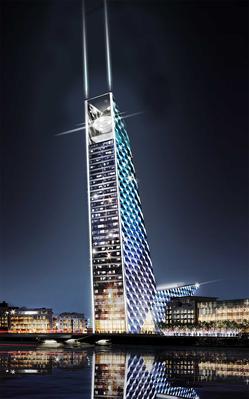
The U2 Tower was a cancelled skyscraper which was proposed to be constructed in Dublin, Ireland. The site proposed was in the South Docklands (SODO) campshires, at the corner of Sir John Rogerson's Quay and Britain Quay, by the confluence of the River Liffey, the River Dodder, and the Grand Canal. The design announced on 12 October 2007 was by Foster and Partners. Reports suggested a building height of 120 metres, "well over 120 metres", and 180 metres, any of which would have made it the tallest building on the island of Ireland. The building was planned to be an apartment building, with a recording studio owned by the rock group U2 in a "pod" at the top. Construction was to begin in 2008 and end in 2011, at a cost of €200m. In October 2008, the project was cancelled because of the economic downturn at the time. Proposals to revive the plan were reported in July 2013. However, they did not come to fruition and the 79-metre, 22-storey Capital Dock development has since been built on the site.

<span class="mw-page-title-main">Point Village</span> Mixed-use development in the northern Docklands of Dublin

The Point Village is a commercial and residential development in the North Wall area of Dublin, Ireland. The elements of the €800 million development completed to date include offices and residential and hotel accommodation, a small shopping centre, a cinema, a museum and a five-level underground car park. The development ran into a number of problems and was taken over by NAMA in April 2013.

<span class="mw-page-title-main">Sir John Rogerson's Quay</span> Street in Dublin, Ireland

Sir John Rogerson's Quay is a street and quay in Dublin on the south bank of the River Liffey between City Quay in the west and Britain Quay. Named for politician and property developer Sir John Rogerson (1648–1724), the quay was formerly part of Dublin Port. It has some of the few remaining campshire warehouses in Dublin.

<span class="mw-page-title-main">Britain Quay</span> Street and quay in Dublin, Ireland

Britain Quay is a street and quay in Dublin on the south bank of the River Liffey between Sir John Rogerson's Quay and the confluence of the River Liffey, River Dodder and Grand Canal.

<span class="mw-page-title-main">Boland's Mill</span> Mixed use development in Dublin City

Boland's Mill is located on the Grand Canal Dock in Dublin, Ireland on Ringsend Road between the inner basin of Grand Canal Dock and Barrow Street. As of 2019, it was undergoing a €150 million reconstruction to become Bolands Quay, a development of new residences and commercial, retail, and civic spaces. The site, originally associated with Boland's Bakery, includes a number of 19th century warehouses.

<span class="mw-page-title-main">South Lotts</span> Neighbourhood of Dublin

South Lotts is a small area to the south of the river Liffey in inner-city Dublin 4, one km east of Dublin City Centre, Ireland. It was created following the embankment of the River Liffey in 1711 between the city and Ringsend, thereby reclaiming the marshes as North and South Lotts. It is at the westernmost end of Ringsend, overlapping with the Grand Canal Dock area, but is generally accepted to be within Ringsend.

<span class="mw-page-title-main">Bord Gáis Energy Theatre</span> Irelands largest all-seated indoor theatre

The Bord Gáis Energy Theatre is a performing arts venue, located in the Docklands of Dublin, Ireland. It is Ireland's largest fixed-seat theatre. It was designed by Daniel Libeskind for the DDDA, built by Joe O'Reilly, and opened by Harry Crosbie on 18 March 2010. It is owned by Bernie and John Gallagher, who bought the theatre in 2014 from NAMA, through their company, Crownway.

<span class="mw-page-title-main">Johnny Ronan</span> Irish businessman and property developer (born 1953)

John Ronan is an Irish businessman and property developer known for establishing Treasury Holdings in 1989 along with Richard Barrett.

<span class="mw-page-title-main">Silicon Docks</span> Area in Dublin, Ireland

Silicon Docks is a nickname for the area in Dublin, Ireland around Grand Canal Dock, stretching to the IFSC, city centre east, and city centre south near the Grand Canal. The nickname makes reference to Silicon Valley, and was adopted because of the concentration of European headquarters of high-tech companies such as Google, Facebook, Twitter, LinkedIn, Indeed and startups in the area. The number of tech professionals working in technology firms in the area is about 7,000.

The Docklands Strategic Development Zone (SDZ) (known officially as the North Lotts and Grand Canal Dock SDZ Planning Scheme) is a controversial strategic planning area in Dublin, Ireland located east of the city centre on both sides of the River Liffey in the North Wall and Grand Canal Dock areas.

<span class="mw-page-title-main">Alto Vetro</span> Apartment block on the western side of Grand Canal Dock

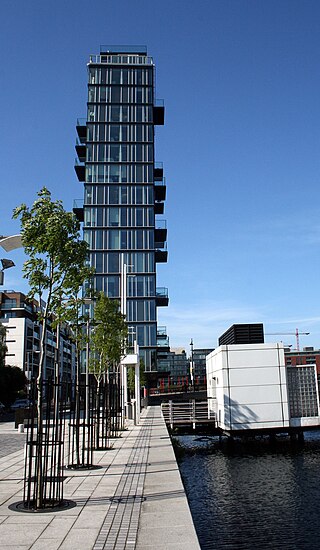
Alto Vetro is a 16-storey residential tower on the west side of Grand Canal Dock, to the south of MacMahon Bridge, in Dublin, Ireland. The structure contains 26 apartments, 24 of them two-bedroom, the top two being three-bedroom triplex penthouses. There is a coffee shop and barbers at ground floor level.

<span class="mw-page-title-main">Misery Hill</span> Street in Dublin, Ireland

Misery Hill is a street in Dublin, Ireland, near Grand Canal Dock.

<span class="mw-page-title-main">Harry Crosbie</span> Irish property developer and music venue operator

Harry Crosbie, OBE is an Irish property developer and entrepreneur from the Dublin suburb of Drumcondra. He is known for his work in redeveloping the Dublin Docklands, and his association with arts and events venues in Dublin city, including the Convention Centre, Vicar Street, The Point Depot/3Arena and the Grand Canal Theatre, as well as the Point Village, and the Wheel of Dublin ferris wheel.

References

  1. "Google". Archived from the original on 26 February 2014. Retrieved 4 March 2014.
  2. 1 2 Barber, Lynsey (17 June 2014). "In pictures: Inside Facebook's new Dublin office and European HQ". Archived from the original on 19 October 2014. Retrieved 15 October 2014.
  3. "Facebook to move to bigger Dublin offices". RTÉ. 7 November 2014. Archived from the original on 10 August 2015. Retrieved 30 June 2014.
  4. 1 2 Dillon-Scott, Piers (29 January 2012). "Google to open 'Google Docks' in Dublin". The Sociable. Archived from the original on 4 March 2014. Retrieved 4 March 2014.
  5. O'Brien, Ciara (7 November 2013). "Facebook confirms move for Dublin HQ to bigger premises". Irish Times. Archived from the original on 4 March 2014. Retrieved 4 March 2014.
  6. Parfeni, Lucien (26 September 2011). "Twitter Joins Google, Facebook and Sets Up International HQ in Dublin, Ireland". Softpedia. Archived from the original on 16 October 2013. Retrieved 4 March 2014.
  7. "LinkedIn to open HQ in Dublin". Irish Independent. 30 November 2012. Archived from the original on 4 March 2014. Retrieved 4 March 2014.
  8. Lyons, Tom (18 January 2014). "Airbnb finds its home in Dublin 4". Irish Times. Archived from the original on 8 April 2014. Retrieved 8 April 2014.
  9. "Austin as Tech Hub: Myth or Reality?". Austin Chronicle. 28 October 2016. Archived from the original on 12 December 2019. Retrieved 12 December 2019.
  10. "Grand Canal Docks, Hanover Quay/Grand Canal Quay/ Ringsend Road, South Dock Road/Grand Canal Place, Dublin 2, DUBLIN". National Inventory of Architectural Heritage . Retrieved 7 April 2021.
  11. Hedderman, Zara (3 October 2018). "Double Take: The little-noticed laneway called Misery Hill in Dublin". TheJournal.ie. Retrieved 22 November 2021.
  12. Bunbury, Turtle (1 January 2009). Dublin Docklands - An Urban Voyage. Montague Publications Group. p. 251. ISBN   9780955815515.
  13. Newenham, Pamela (19 January 2015). Silicon Docks: The Rise of Dublin as a Local Tech Hub. Liberties Press. p. 200. ISBN   9781910742006.
  14. Melia, Paul (23 May 2014). "Green light for massive Docklands development". The Independent . Archived from the original on 23 May 2014. Retrieved 25 June 2014.
  15. Taylor, Charlie (14 October 2014). "U2 to buy Hanover Quay site from DDDA for €450,000". Irish Times. Archived from the original on 21 January 2015. Retrieved 21 January 2015.
  16. 1 2 "The Marker Hotel". Irish Building Magazine. 10 September 2013. Archived from the original on 21 January 2015. Retrieved 21 January 2015.
  17. "Grand Canal Quay's Alto Vetro Wins RIAI's Silver Medal for Housing". Royal Institute of the Architects of Ireland. 13 September 2011. Archived from the original on 11 March 2014. Retrieved 11 March 2014.
  18. Kelly, Olivia (2 July 2015). "Green light for €150m Boland's Mill development". The Irish Times. Archived from the original on 13 August 2015. Retrieved 10 September 2015.
  19. "Grand Canal Theatre to change name as part of Bord Gáis deal". Irish Times. 25 October 2011. Archived from the original on 25 October 2011. Retrieved 11 March 2014.
  20. Coyle, Colin (1 April 2012). "Google plans bridge to link three Dublin offices". The Sunday Times. Archived from the original on 10 March 2014. Retrieved 10 March 2014.
  21. "Works Start on Google Bridge". Bennett Construction. 17 February 2014. Archived from the original on 10 March 2014. Retrieved 10 March 2014.

53°20′37″N6°14′15″W / 53.343497°N 6.23762°W / 53.343497; -6.23762