Grand Rivers, Kentucky

Last updated

Grand Rivers, Kentucky
Grand-Rivers-KY.jpg
Downtown Grand Rivers, Kentucky
Livingston County Kentucky Incorporated and Unincorporated areas Grand Rivers Highlighted 2132212.svg
Location of Grand Rivers in Livingston County, Kentucky.
Coordinates: 37°00′18″N88°13′58″W / 37.00500°N 88.23278°W / 37.00500; -88.23278
Country United States
State Kentucky
County Livingston
Named for the nearby Cumberland, Tennessee, and Ohio rivers
Area
[1]
  Total1.97 sq mi (5.10 km2)
  Land1.85 sq mi (4.80 km2)
  Water0.12 sq mi (0.30 km2)
Elevation
[2]
423 ft (129 m)
Population
 (2020)
  Total345
  Density186.18/sq mi (71.90/km2)
Time zone UTC-6 (Central (CST))
  Summer (DST) UTC-5 (CDT)
ZIP code
42045
Area code(s) 270 & 364
FIPS code 21-32212
GNIS feature ID2403725 [2]
Website www.grandrivers.org

Grand Rivers is a home rule-class city in Livingston County, Kentucky, in the United States. The population was 382 at the 2010 census, up from 343 in 2000. It is part of the Paducah, KY-IL Metropolitan Statistical Area.

Contents

Geography

Boston financier Thomas Lawson's residence in Grand Rivers, when he was promoting the town as the next great steel-making center, to rival Pittsburgh and Birmingham. Thomas-Lawson-House-Grand.jpg
Boston financier Thomas Lawson's residence in Grand Rivers, when he was promoting the town as the next great steel-making center, to rival Pittsburgh and Birmingham.

According to the United States Census Bureau, the city has a total area of 1.9 square miles (4.9 km2), of which 1.8 square miles (4.8 km2) is land and 0.04 square miles (0.10 km2) (2.13%) is water.

The town was formerly located at the narrowest point between the Cumberland River and the Tennessee. Both were dammed and artificial lakes created by the Tennessee Valley Authority and the Army Corps of Engineers in the early 20th century; the town now lies on an isthmus of land between Kentucky Lake and Lake Barkley.

History

Grand Rivers may have originally been known as Narrows from its position between the Cumberland and Tennessee Rivers. The local post office was established in 1879 as Otisville; changed its name in 1882 to Bernard; and was then changed again to Nickells the next year after the name of a new Illinois Central station. [3]

The settlement was formally incorporated by the state assembly in 1890 as Grand Rivers. [4] This newly expanded community was part of local businessman Thomas W. Lawson's attempt to develop local iron deposits into a major steel industry. (The enterprise failed within a few years.) The name refers the Cumberland and Tennessee rivers which previously met near the site, [3] prior to the TVA's creation of Kentucky Lake and Lake Barkley. The Tennessee's confluence with the Ohio is located within 40 miles of the town as well.

Demographics

Historical population
CensusPop.Note
1920 478
1930 452−5.4%
1940 49910.4%
1950 234−53.1%
1960 37861.5%
1970 43815.9%
1980 428−2.3%
1990 351−18.0%
2000 343−2.3%
2010 38211.4%
2020 345−9.7%
U.S. Decennial Census [5]

As of the census [6] of 2000, there were 343 people, 165 households, and 103 families residing in the city. The population density was 186.1 inhabitants per square mile (71.9/km2). There were 201 housing units at an average density of 109.1 per square mile (42.1/km2). The racial makeup of the city was 97.08% White, 0.29% Native American, 0.29% Pacific Islander, 1.17% from other races, and 1.17% from two or more races. Hispanic or Latino of any race were 1.17% of the population.

There were 165 households, out of which 17.6% had children under the age of 18 living with them, 53.3% were married couples living together, 4.8% had a female householder with no husband present, and 37.0% were non-families. 33.9% of all households were made up of individuals, and 17.6% had someone living alone who was 65 years of age or older. The average household size was 2.07 and the average family size was 2.63.

In the city, the population was spread out, with 16.6% under the age of 18, 5.2% from 18 to 24, 21.3% from 25 to 44, 35.9% from 45 to 64, and 21.0% who were 65 years of age or older. The median age was 50 years. For every 100 females, there were 101.8 males. For every 100 females age 18 and over, there were 98.6 males.

The median income for a household in the city was $33,250, and the median income for a family was $42,917. Males had a median income of $28,750 versus $15,521 for females. The per capita income for the city was $21,642. About 8.7% of families and 10.1% of the population were below the poverty line, including 14.3% of those under age 18 and 9.0% of those age 65 or over.

Related Research Articles

<span class="mw-page-title-main">Stewart County, Tennessee</span> County in Tennessee, United States

Stewart County is a county located on the northwestern corner of Middle Tennessee, in the U.S. state of Tennessee. As of the 2020 census, the population was 13,657. Its county seat is Dover. Stewart County is part of the Clarksville Metropolitan Statistical Area.

<span class="mw-page-title-main">Pickett County, Tennessee</span> County in Tennessee, United States

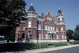
Pickett County is a county located in the U.S. state of Tennessee. As of the 2020 census, the population was 5,001, making it the least populous county in Tennessee. Its county seat is Byrdstown. The city of Byrdstown and the Kentucky town of Albany, 11 miles (18 km) to the northeast, are positioned between two Army Corps of Engineers lakes: Dale Hollow Lake, mainly in Tennessee, and Lake Cumberland, in Kentucky. The area is known as "Twin Lakes" and Byrdstown is noted as "The Gateway To Dale Hollow Lake". Every year thousands of people vacation at the many resorts situated along the lakes.

<span class="mw-page-title-main">Livingston County, Kentucky</span> County in Kentucky, United States

Livingston County is a county located in the U.S. state of Kentucky. As of the 2020 census, the population was 8,888. Its county seat is Smithland and its largest community is Ledbetter. The county was established in 1798 from land taken from Christian County and is named for Robert R. Livingston, a member of the Committee of Five that drafted the U.S. Declaration of Independence. The county was strongly pro-Confederate during the American Civil War and many men volunteered for the Confederate Army. Livingston County is part of the Paducah, KY-IL Metropolitan Statistical Area. It is a prohibition or dry county with the exception of Grand Rivers which voted to allow alcohol sales in 2016.

<span class="mw-page-title-main">Fulton County, Kentucky</span> County in Kentucky, United States

Fulton County is the westernmost county in the U.S. state of Kentucky, with the Mississippi River forming its western boundary. As of the 2020 census, the population was 6,515. Its county seat is Hickman and its largest city is Fulton. The county was formed in 1845 from Hickman County, Kentucky and named for Robert Fulton, the inventor of the steamboat.

<span class="mw-page-title-main">Dycusburg, Kentucky</span> Unincorporated community in Kentucky, United States

Dycusburg is an unincorporated community in Crittenden County, Kentucky, United States. The population was 26 at the 2010 census.

<span class="mw-page-title-main">Burkesville, Kentucky</span> City in Kentucky, United States

Burkesville is a home rule-class city in Cumberland County, Kentucky, in the United States. Nestled among the rolling foothills of Appalachia and bordered by the Cumberland River to the south and east, it is the seat of its county. The population was 1,521 at the 2010 census.

<span class="mw-page-title-main">Loyall, Kentucky</span> City in Kentucky, United States

Loyall is a home rule-class city in Harlan County, Kentucky, in the United States. The population was 1,461 as of the 2010 census, up from 766 at the time of the 2000 census.

<span class="mw-page-title-main">Wallins Creek, Kentucky</span> Census-designated place in Kentucky, United States

Wallins Creek is an unincorporated community and census-designated place (CDP) in Harlan County, Kentucky, United States. The population was 156 at the 2010 census, when it was still a city, having dropped from 257 at the 2000 census.

<span class="mw-page-title-main">Ledbetter, Kentucky</span> CDP in Kentucky, United States

Ledbetter is a census-designated place (CDP) in Livingston County, Kentucky, United States. The population was 1,683 at the 2010 census, down slightly from 1,700 in 2000, thus making it the largest and most populous community in Livingston County. It is part of the Paducah, KY-IL Micropolitan Statistical Area, laying directly across the Tennessee River from Paducah.

<span class="mw-page-title-main">Smithland, Kentucky</span> City in Kentucky, United States

Smithland is a home rule-class city in Livingston County, Kentucky, United States, at the confluence of the Ohio and Cumberland Rivers. The population was 301 at the 2010 census, a drop from 401 in 2000. It is the county seat of Livingston County.

<span class="mw-page-title-main">Eddyville, Kentucky</span> City in Kentucky, United States

Eddyville is a home rule-class city in and the county seat of Lyon County, Kentucky, United States. The population was 2,554 at the 2010 census, up from 2,350 in 2000. The Kentucky State Penitentiary is located at Eddyville. The town is considered a tourist attraction because of its access to nearby Lake Barkley.

<span class="mw-page-title-main">Kuttawa, Kentucky</span> City in Kentucky, United States

Kuttawa is a home rule-class city in Lyon County, Kentucky, in the United States. The population was 649 as of the 2010 census, up from 596 in 2000.

<span class="mw-page-title-main">Pine Knot, Kentucky</span> Census-designated place in Kentucky, United States

Pine Knot is an unincorporated community and census-designated place (CDP) in McCreary County, Kentucky, United States. The population was 1,380 at the 2020 census, down from 1,621 in 2010.

<span class="mw-page-title-main">Stearns, Kentucky</span> Census-designated place in Kentucky, United States

Stearns is an unincorporated community and census-designated place (CDP) in McCreary County, Kentucky, United States. The population was 1,365 at the 2020 census. It was founded by Justus Smith Stearns.

<span class="mw-page-title-main">Tompkinsville, Kentucky</span> City in Kentucky, United States

Tompkinsville is a home rule-class city in and the county seat of Monroe County, Kentucky, United States. The population was 2,309 at the 2020 census. The city was named after Vice President Daniel D. Tompkins who served under President James Monroe, for whom the county was named.

<span class="mw-page-title-main">Russell Springs, Kentucky</span> City in Kentucky, United States

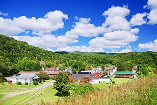
Russell Springs is a home rule-class city in Russell County, Kentucky, in the United States. The city is the gateway to Lake Cumberland, one of the largest man-made lakes in the region, created by Wolf Creek Dam. It is the largest city in the county, having a population of 2,441 during the year 2010 U.S. Census.

<span class="mw-page-title-main">Ashland City, Tennessee</span> Town in Tennessee, United States

Ashland City is a town and the county seat of Cheatham County, Tennessee. Located in Middle Tennessee, it is part of the Nashville-Davidson–Murfreesboro–Franklin, TN Metropolitan Statistical Area. As of the 2020 census, the town's population was 5,193.

<span class="mw-page-title-main">Celina, Tennessee</span> City in Tennessee, United States

Celina is a city in and the county seat of Clay County, Tennessee, United States. The population was 1,495 at the 2010 census.

<span class="mw-page-title-main">Dover, Tennessee</span> City in Tennessee, United States

Dover is a city in and the county seat of Stewart County, Tennessee, 67 miles (108 km) west-northwest of Nashville on the Cumberland River. Fort Donelson National Cemetery is in Dover. The population was 1,442 at the 2000 census and the 2010 census showed a population of 1,417.

<span class="mw-page-title-main">Calvert City, Kentucky</span> City in Kentucky, United States

Calvert City is a home rule-class city in Marshall County, Kentucky, United States. The population was 2,514 at the 2020 census.

References

  1. "2020 U.S. Gazetteer Files". United States Census Bureau. Retrieved March 18, 2022.
  2. 1 2 U.S. Geological Survey Geographic Names Information System: Grand Rivers, Kentucky
  3. 1 2 Rennick, Robert M. (1987). Kentucky Place Names. University Press of Kentucky. p. 121. Retrieved April 28, 2013.
  4. Commonwealth of Kentucky. Office of the Secretary of State. Land Office. "Grand Rivers, Kentucky". Accessed 28 July 2013.
  5. "Census of Population and Housing". Census.gov. Retrieved June 4, 2015.
  6. "U.S. Census website". United States Census Bureau . Retrieved January 31, 2008.