Waterford is a town in New London County, Connecticut. It is named after Waterford, Ireland. The town is part of the Southeastern Connecticut Planning Region. The population was 19,571 at the 2020 census. The town center is listed as a census-designated place (CDP) and had a population of 3,074 at the 2020 census.

Gales Ferry is a village in the town of Ledyard, Connecticut, United States. It is located along the eastern bank of the Thames River. The village developed as a result of having a ferry to Uncasville located at this site, and from which the village was named. Gales Ferry was listed as a census-designated place for the 2010 Census, with a population of 1,162.

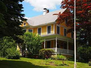
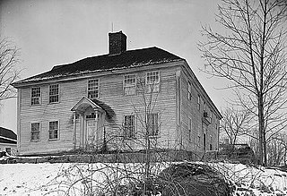
Jordan is a village in the town of Waterford, Connecticut, and the historic center of the town. It was named from the Jordan River. The village was listed on the National Register of Historic Places as Jordan Village Historic District in 1990.

The Noank Historic District is a historic district encompassing the historic main part of the village of Noank in the town of Groton, Connecticut. The district contains a distinctive assortment of mid-to-late 19th-century residential architecture that is notable for its often picturesque woodwork. At the time of their construction, the village was primarily a worker village for nearby shipyards. The district was listed on the National Register of Historic Places in 1979.
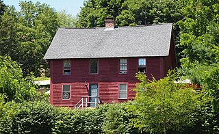
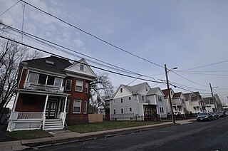
The Quaker Hill Historic District encompasses the center a mainly residential village in northeastern Waterford, Connecticut. Running in a mostly linear fashion along Old Norwich Road between Connecticut Route 32 and Richard Grove Road, the area first grew as a settlement of religious non-conformists in the 17th century, developed in the 19th century as a small industrial village, and became more suburban in character in the 20th century. Its architecture is reflective of these changes, and it was listed on the National Register of Historic Places in 2002.
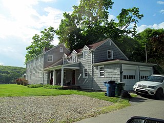
The Oswegatchie Historic District is a historic district in the town of Waterford, Connecticut, United States. The historic district is located on a peninsula on the east side of the tidal Niantic River, and represents a cross-section of historic coastal land uses, from farming to a small colony of summer estates to year-round living. The district was listed on the National Register of Historic Places in 2005.

The Stony Creek–Thimble Islands Historic District is a historic district encompassing a 19th-century summer resort area in Branford, Connecticut. Located in the southeastern part of the town, it encompasses the mainland Stony Creek neighborhood, and all of the major Thimble Islands which lie offshore from Stony Creek in Long Island Sound. The district includes a well-preserved array of domestic summer resort architecture spanning more than a century preceding World War II, as well as worker housing and other artifacts related to the area's brief importance as a granite quarry. The district was listed on the National Register of Historic Places in 1988.

The Hotchkissville Historic District is a historic district in the town of Woodbury, Connecticut, that was listed on the National Register of Historic Places in 1995. The district encompasses most of the historic village of Hotchkissville, which is centered at the junction of Washington and Weekeepeemee roads. The village began as a dispersed rural agricultural community, but developed in the 19th century with the arrival of industry, primarily the manufacture of textiles. Despite this, the village has retained a significantly rural character, and includes a broad cross-section of 18th- and 19th-century architectural styles.
The Pine Meadow Historic District encompasses most of the historic 19th-century village of Pine Meadow in New Hartford, Connecticut. Located at a bend in the West Branch of the Farmington River southeast of New Hartford center, it is a well-preserved example of a rural industrial village. The district was listed on the National Register of Historic Places in 1996.

The Main Street Historic District encompasses the historic civic, commercial, and residential center of Durham, Connecticut. The district is primarily linear and runs along Main Street from between Higganum Road and Town House Road in the south to Talcott Lane in the north, and along Maple Avenue, which parallels Main Street. The district includes most of its colonial architecture, as well as many of its civic buildings. It was listed on the National Register of Historic Places in 1986.
The North Stonington Village Historic District is a 105-acre (42 ha) historic district encompassing the historic center of the main village of North Stonington, Connecticut. The district includes a well-preserved small industrial village, which flourished in the years before the American Civil War, and declined afterward. The district was listed on the National Register of Historic Places in 1983.

The New London Custom House is a historic custom house at 150 Bank Street in New London, Connecticut, built in 1833-35. It was designed by Robert Mills, one of the country's first formally trained architects. From 1839-40, the schooner La Amistad, on which captured Africans meant for the slave trade rebelled, was impounded at a wharf behind the customhouse. It was listed on the National Register of Historic Places for its architecture in 1970, and is now a local museum covering the city's maritime history.

The Bradley Edge Tool Company Historic District encompasses the surviving remnants of a historic 19th-century industrial village in Weston, Connecticut. Extending along Lyons Plain Road near White Birch Road and the Saugatuck River, the area was home to the Bradley Edge Tool Company, which flourished here between 1834 and 1870. The principal surviving elements are residences which were built for the owners and workers of the company; the factory itself burned in 1911. The district was listed on the National Register of Historic Places in 1995.

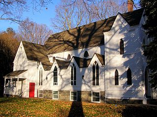
The Hadlyme North Historic District is an 81-acre (33 ha) historic district located in the southwest corner of the town of East Haddam, Connecticut. It represents the historic core of the village of Hadlyme, which straddles the town line, and consists primarily of two north-south roads, Town Street. The village arose around a church society founded in 1743, and grew with the development of small industries along area waterways. It was listed on the National Register of Historic Places in 1988.

The Barre Downtown Historic District encompasses the historic commercial and civic heart of the city of Barre, Vermont. Extending along Main Street from City Park to Depot Square, this area was developed quite rapidly in the 1880s and 1890s, when the area experienced rapid growth due to the expansion of the nearby granite quarries. It was listed on the National Register of Historic Places in 1979.

The Currier Park Historic District encompasses a historic late 19th-century affluent residential area of the city of Barre, Vermont. Centered around Currier Park, a rectangular park laid out in 1883 just east of the city's downtown, are a collection of a high quality predominantly Italianate and Queen Anne Victorian residences. The district was listed on the National Register of Historic Places in 1990.
The Allen Place–Lincoln Street Historic District encompasses a small neighborhood of late 19th-century housing built for white-collar service workers in southern Hartford, Connecticut. It is roughly bounded by Madison, Washington, and Vernon Streets, and Zion Hill Cemetery, and has well-preserved examples of vernacular Queen Anne and Colonial Revival architecture. It was listed on the National Register of Historic Places in 2003.
The Elm Street Historic District encompasses a colonial-era roadway layout and a cross-section of historical residential architecture styles in Rocky Hill, Connecticut. Elm Street between Silas Deane Highway and Grimes Road is an old colonial road, laid out in the late 17th century, and has retained an unusually wide right-of-way, typical for the period but rarely preserved. The houses lining it date from 1769 to the 1930s. The district was listed on the National Register of Historic Places in 1998.

The Palisado Avenue Historic District encompasses a predominantly residential streetscape in northeastern Windsor, Connecticut. Extending along Palisado Avenue between the Farmington River and Bissell Ferry Road, it is a basically 18th-century street view, populated mainly with houses from the 18th to the 20th centuries. The district was listed on the National Register of Historic Places in 1987.

The Marlborough Street Historic District encompasses one of the finest collections of 19th-century residential architecture in Portland, Connecticut. Extending along Marlborough Street east of Main Street, it includes twelve houses built between 1847 and 1900 in a variety of architectural styles. The district was listed on the National Register of Historic Places in 1983.


