Great Casterton

Last updated

Great Casterton
Saint Peter and Paul's Church, Great Casterton - geograph.org.uk - 732997.jpg
Rutland UK location map.svg
Red pog.svg
Great Casterton
Location within Rutland
Area3.6 sq mi (9.3 km2)  [1]
Population600 (Including Tickencote)2011 Census [2]
  Density 121/sq mi (47/km2)
OS grid reference TF005090
  London 83 miles (134 km) SSE
Unitary authority
Shire county
Ceremonial county
Region
Country England
Sovereign state United Kingdom
Post town STAMFORD
Postcode district PE9
Dialling code 01780
Police Leicestershire
Fire Leicestershire
Ambulance East Midlands
UK Parliament
List of places
UK
England
Rutland
52°40′10″N0°30′46″W / 52.6694°N 0.5128°W / 52.6694; -0.5128

Great Casterton is a village and civil parish in the county of Rutland in the East Midlands of England. It is located at the crossing of the Roman Ermine Street and the River Gwash.

Contents

Geography

The village is approximately three miles to the north-west of Stamford and very close to the county border with Lincolnshire (South Kesteven). Just to the north is Tickencote.

The parish boundary, to the south and east, lies close to the village, and follows the River Gwash. Just west of the B1081 bridge over the Gwash, it borders Tinwell. Just to the west of Ingthorpe (part of Tinwell), it borders Tickencote. The parish boundary crosses the A1 at the turn off for the village. The boundary then follows the A1 north, along the next hedge to the east (a field's width). It passes to the east of Tickencote Warren, and at Exeter Gorse it briefly borders Horn, then meets Pickworth. It passes to the south of Eayres Lodge, includes Woodhead, crossing Pickworth Road south of Taylor's Farm. West of Tolethorpe Oaks, it briefly meets Ryhall, then borders Little Casterton southwards, passing Frith Farm to the west and broadly follows the Danelaw Way. North of Little Casterton village, the boundary meets the Gwash.

The A1 road which follows the path of Ermine Street, ran through the centre of the village until the construction of the Stamford bypass in 1960; the former route of the Great North Road is now the B1081.

There is a very small nature reserve, Great Casterton Road Banks, to the south of the village containing examples of rare plants such as Sulphur Clover and Greater Broomrape.

History

Roman town Great Casterton Roman Town - geograph.org.uk - 132451.jpg
Roman town
The Rectory and Parish Church in 1912 The Old Rectory Great Casterton.jpg
The Rectory and Parish Church in 1912

The village's name means 'farm/settlement which was/near a Roman site'. [3]

The earliest recorded settlement was a Roman fort ca 44 AD. [4] A civilian settlement developed which was later a walled town and the defences are still apparent. Archaeological excavations have been conducted on the town, a villa near the Gwash and burials including early Anglo-Saxons. Two miles north of the town are the earthwork remains of Woodhead Castle, a medieval moated ringwork with attached bailey.

The parish church, dedicated to St Peter & St Paul, is recorded in the National Heritage List for England as a designated Grade I listed building. [5] The churchyard is entered through an arched war memorial remembering the dead of both World Wars. The benefice is shared with Pickworth, Tickencote and Little Casterton. The poet John Clare was married to Martha "Patty" Turner at Great Casterton church in 1820.

Amenities

The village has both a primary school, Great Casterton Church of England Primary School, and a secondary, Casterton College. The remaining pub in the village is the Crown Inn.

Related Research Articles

<span class="mw-page-title-main">Ermine Street</span> Roman road from London to York, England

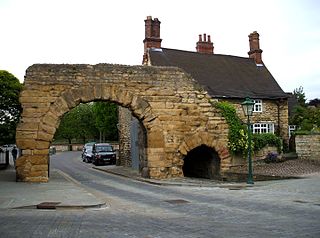
Ermine Street is a major Roman road in England that ran from London (Londinium) to Lincoln and York (Eboracum). The Old English name was Earninga Strǣt (1012), named after a tribe called the Earningas, who inhabited a district later known as Armingford Hundred, around Arrington, Cambridgeshire, and Royston, Hertfordshire. "Armingford", and "Arrington" share the same Old English origin. The original Celtic and Roman names for the route remain unknown. It is also known as the Old North Road from London to where it joins the A1 Great North Road near Godmanchester.

<span class="mw-page-title-main">Stamford, Lincolnshire</span> Town in Lincolnshire, England

Stamford is a town and civil parish in the South Kesteven District of Lincolnshire, England. The population at the 2011 census was 19,701 and estimated at 20,645 in 2019. The town has 17th- and 18th-century stone buildings, older timber-framed buildings and five medieval parish churches. It is a frequent film location. In 2013 it was rated a top place to live in a survey by The Sunday Times. Its name has been passed on to Stamford, Connecticut, founded in 1641.

<span class="mw-page-title-main">South Kesteven</span> Local government district in Lincolnshire, England

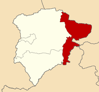
South Kesteven is a local government district in Lincolnshire, England, forming part of the traditional Kesteven division of the county. It covers Bourne, Grantham, Market Deeping and Stamford. The 2011 census reports 133,788 people at 1.4 per hectare in 57,344 households. The district borders the counties of Cambridgeshire, Leicestershire, Northamptonshire, Nottinghamshire and Rutland. It is also bounded by the Lincolnshire districts of North Kesteven and South Holland.

<span class="mw-page-title-main">Ancaster, Lincolnshire</span> Village in the South Kesteven district of Lincolnshire, England

Ancaster is a village and civil parish in the South Kesteven district of Lincolnshire, England, on the site of a Roman town. The population of the civil parish was 1,317 at the 2001 census increasing to 1,647 at the 2011 census. The civil parish includes the settlements of Sudbrook and West Willoughby.

<span class="mw-page-title-main">Stretton, Rutland</span> Human settlement in England

Stretton is a village and civil parish in the county of Rutland, England, just off the A1 Great North Road. The population of the civil parish was 770 at the 2001 census, including Thistleton and increasing to 1,260 at the 2011 census. The ecclesiastical parish of Stretton shares the same boundaries and is part of the Rutland deanery of the diocese of Peterborough.

<span class="mw-page-title-main">Pickworth, Rutland</span> Human settlement in England

Pickworth is a civil parish and small village in the county of Rutland. The population of the civil parish at the 2001 census was 81. This remained less than 100 at the 2011 census and was included in the town of Stamford.

<span class="mw-page-title-main">Ryhall</span> Village and civil parish in Rutland, England

Ryhall is a village and civil parish in the county of Rutland in the East Midlands of England. It is situated close to the eastern boundary of the county, about 2 miles (3 km) north of Stamford. The parish includes the hamlet of Belmesthorpe.

<span class="mw-page-title-main">Little Casterton</span> Human settlement in England

Little Casterton is a small village and civil parish in Rutland, England. The population of the civil parish at the 2001 census was 148, increasing to 218 at the 2011 census. It is about two miles (3 km) north of Stamford on a minor road that runs to the south of the River Gwash between Great Casterton and Ryhall.

<span class="mw-page-title-main">Tolethorpe Hall</span> Country house near Stamford, Lincolnshire

Tolethope Hall in the parish of Little Casterton, Rutland, England, PE9 4BH is a country house near Stamford, Lincolnshire at grid reference TF023104. It is now the location of the Rutland Theatre of the Stamford Shakespeare Company. The hall is a Grade II* Listed Building,

<span class="mw-page-title-main">Braunston-in-Rutland</span> Village and civil parish in Rutland, England

Braunston-in-Rutland is a village and civil parish in the county of Rutland in the East Midlands of England. The population of the civil parish was 392 at the 2001 census, including Brooke and increasing to 502 at the 2011 census. Leicestershire lies on the parish's western boundary

<span class="mw-page-title-main">Market Overton</span> Human settlement in England

Market Overton is a village on the northern edge of the county of Rutland in the East Midlands of England. The population of the civil parish was 494 at the 2001 census, increasing to 584 at the 2011 census.

<span class="mw-page-title-main">Tickencote</span> Human settlement in England

Tickencote is a small village and civil parish in the county of Rutland in the East Midlands of England. It is noted for St Peter's Church, with its Norman chancel arch. The population at the 2001 census was 67. At the 2011 census the population remained less than 100 and was included together with the parish of Great Casterton.

<span class="mw-page-title-main">Tinwell</span> Human settlement in England

Tinwell is a village and civil parish in the county of Rutland in the East Midlands of England. The population at the 2001 census was 209, increasing to 234 at the 2011 census.

<span class="mw-page-title-main">Arrington, Cambridgeshire</span> Human settlement in England

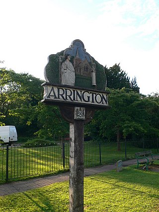
Arrington is a small village and civil parish in the South Cambridgeshire district of Cambridgeshire, England, with a population of 415 at the time of 2011 census. The village is 6 miles (10 km) north of Royston, Hertfordshire, and 9 miles (14 km) south-west of the county city of Cambridge.

<span class="mw-page-title-main">Ketton Rural District</span>

Ketton was a rural district in Rutland, England from 1894 to 1974, covering the east of the county. The district was named after Ketton.

<span class="mw-page-title-main">A606 road</span> Road in East Midlands

The A606 is an A road in England that starts in West Bridgford, on the outskirts of Nottingham, and heads southeastwards through Leicestershire and the towns of Melton Mowbray and Oakham, terminating at Stamford, Lincolnshire on the former Great North Road.

<span class="mw-page-title-main">A6121 road</span> Road in England

The A6121 is a short cross-country road in the counties of Lincolnshire and Rutland, England. It forms the principal route between Bourne and Stamford and the A1 in Lincolnshire, continuing on through Ketton in Rutland to its junction with the A47 at Morcott. Its south-western end is at 52°35.5860′N0°38.0820′W and its north-eastern end is at 52°45.9120′N0°24.0660′W. The road has increased in importance with the rapid expansion of housing in this part of South Kesteven.

<span class="mw-page-title-main">Tickencote Marsh</span> Protected area in Rutland, England

Tickencote Marsh is a three hectare biological Site of Special Scientific Interest west of Tickencote and Great Casterton in Rutland.

<span class="mw-page-title-main">All Saints' Church, Pickworth</span> Church in Pickworth, Rutland

All Saints' Church is the Church of England parish church in Pickworth, Rutland. Built in 1821, it is a Grade II listed building.

References

  1. "A vision of Britain through time". University of Portsmouth. Retrieved 15 February 2009.
  2. "Rutland Civil Parish Populations" (PDF). Rutland County Council. 2011. Retrieved 23 June 2016.
  3. "Key to English Place-names". kepn.nottingham.ac.uk.
  4. "Roman Britain - Organisation". 10 June 2023. Archived from the original on 18 February 2007.
  5. Historic England. "Church of St Peter & St Paul, Great Casterton (1073841)". National Heritage List for England . Retrieved 27 March 2015.

Video clips