
Breckland is a local government district in Norfolk, England. Its council is based in Dereham. The district had a population of 130,491 at the 2011 Census.

Burnham Market is an English village and civil parish near the north coast of Norfolk. Burnham Market is one of the Burnhams, a group of adjacent villages. It results from a merger of three original villages: Burnham Sutton, Burnham Ulph and Burnham Westgate.
Geldeston is a parish and village in Norfolk. It is about one mile westward of Gillingham and two miles north west of Beccles. Other nearby villages include Ellingham and Kirby Cane, immediately to its west.

Plumstead is a village and a civil parish in the English county of Norfolk. The village is 19.7 miles (31.7 km) north north west of Norwich, 9.5 miles (15.3 km) south-west of Cromer and 134 miles (216 km) north-east of London. The nearest town is Holt which is 4.8 miles (7.7 km) to the north west of the village. The nearest railway station is in the town of Sheringham where access to the national rail network can be made via the Bittern Line to Norwich. The nearest airport is Norwich International Airport. Plumstead falls within the area covered by North Norfolk District Council.
Wayland is an area in the district of Breckland within the English county of Norfolk. It is situated approximately 20 miles west of Norwich.

Hempstead is a village and civil parish in the north of the English county of Norfolk. The village is 2.7 miles south-southeast of the town of Holt, and 11.2 miles west of Cromer. Hempstead is within the area covered by North Norfolk District Council. In the last Census, carried out in 2001, the population of Hempstead was counted as 179, the population slightly reducing to 177 at the 2011 Census.

Little Bealings is a village in Suffolk, England. It has a population of approximately 470 people living in around 185 households. The population had fallen to 420 at the 2011 Census. Its nearest towns are Ipswich and Woodbridge. Nearby villages include Great Bealings, Playford, Culpho, Martlesham and Grundisburgh.

Holme Hale is a village situated in the Breckland District of Norfolk and covers an area of 1069 hectares with an estimated population of 444 as of UK census 2001. The village lies 1 1⁄2 miles (2.4 km) south of Necton and 5 1⁄2 miles (8.9 km) by road east from Swaffham.
Great Dunham is a village situated in the Breckland District of Norfolk and covers an area of 818 hectares with an estimated population of 325, including Kempstone and increasing to a measured population of 344 at the 2011 Census. The village lies 1.5 miles (2.4 km) north of its sister village Little Dunham and 7 miles (11 km) by road north east from Swaffham.
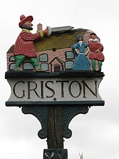
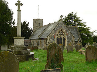
Griston is a village and civil parish in the Wayland area of the Breckland district within the English county of Norfolk. It covers an area of 5.62 km2 (2.17 sq mi) and had a population of 1,206 in 206 households at the 2001 census, increasing to a population of 1,540 in 246 households at the 2011 Census. For the purposes of local government, it falls within the district of Breckland.

Little Ellingham is a village and civil parish in the English county of Norfolk. The village is 4.6 miles (7.4 km) north-west of Attleborough, 2 miles (3.2 km) north-west of its sister village of Great Ellingham, 18.8 miles (30.3 km) west-south-west of Norwich and 105 miles (169 km) north-east of London. The nearest railway station is at Attleborough for the Breckland Line which runs between Cambridge and Norwich. The nearest airport is Norwich International Airport.

Little Cressingham lies 2.5 miles (4.0 km) south east by road from Great Cressingham, 3 miles (4.8 km) west of Watton and 8 miles (13 km) south of Swaffham in the Breckland District of Norfolk. It covers an area of 11.90 km2 (4.59 sq mi) and had a population of 157 in 70 households at the 2001 census It is in the civil parish of Great Cressingham. The village is located on the edge of the Stanford Battle Area.
Great Cressingham is a village which lies about 5 miles (8 km) of Watton, 6 miles (10 km) south of Swaffham and only 1.5 miles (2.4 km) off the A1065 arterial road just north of Hilborough. It is 2.5 miles (4 km) north west by road from Little Cressingham. In 2007 it had an estimated population of 235, in an area of 9.84 km2 (3.80 sq mi), including Little Cressingham and increasing to 421 at the 2011 Census.

Carbrooke is a village and civil parish in the Breckland district of mid-Norfolk, East Anglia, England in the United Kingdom. It is 3 miles (4.8 km) from the centre of Watton, 8 miles (13 km) from Dereham and 17 miles (27 km) from its postal town of Thetford. It has an area of 12.66 km2 (4.89 sq mi) with an estimated population of 1,310 in 2007. The measured population at the Census 2011 was 2,076.

Fransham is a civil parish in the Breckland District of the English county of Norfolk; it covers an area of 12.14 km2 (4.7 sq mi), and includes the villages of Great and Little Fransham and the hamlet of Crane's End. Fransham has an estimated population of 430 as of 2007. It lies 6 miles (9.7 km) east from Swaffham and 6 1⁄2 miles (10.5 km) west from Dereham.

Little Dunham is a village situated in the Breckland District of Norfolk and covers an area of 749 hectares with a population of 309 at the 2001 census. The village lies 1 1⁄2 miles (2.4 km) south of its sister village Great Dunham and 6 miles (10 km) by road north east from Swaffham.

Great Ellingham is a village and civil parish in the Breckland District of Norfolk. The village lies 2.5 miles north-west of Attleborough, 2 miles south-east of its sister village of Little Ellingham and 12 miles by road south from Dereham. The civil parish also includes the hamlets of Bow Street and Stalland Common, and covers an area of 1,114 hectares with a population of 1108 at the 2001 census, though the district's 2007 estimate suggests that this may have risen to 1165, then decreasing to a measured population of 1,132 in 470 households at the 2011 Census.

Kempstone is a village situated in the Breckland District of Norfolk and covers an area of 331 hectares with an estimated population of 18 as of UK census 2001 At the 2011 Census the population remained less 100 and is included in the civil parish of Great Dunham. The village lies 1.2 miles (1.9 km) south of Litcham and 9.3 miles (15.0 km) by road east from Dereham.
Lexham is a parish consisting of the twin villages of East Lexham and West Lexham situated in the Breckland District of Norfolk and covers an area of 9.73 km2 (3.76 sq mi) with a population of 157 at the 2001 census. The Lexham villages are just over a mile apart and lie 6.5 miles (10.5 km) north of Swaffham and 18 miles (29 km) by road east from Kings Lynn.
Hockham is a civil parish in the English county of Norfolk. It covers an area of 13.36 km2 (5.16 sq mi) and had a population of 620 in 252 households at the 2001 census. For the purposes of local government, it falls within the district of Breckland. The district's 2007/08 estimate suggests that the population had risen to 645. At the 2011 Census the population was measured at 603 only in 259 households.

