
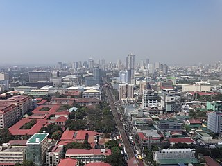
Metropolitan Manila, commonly shortened to Metro Manila and formally the National Capital Region, is the capital region and largest metropolitan area of the Philippines. Located on the eastern shore of Manila Bay, the region lies between the Central Luzon and Calabarzon regions. Encompassing an area of 619.57 km2 (239.22 sq mi) and with a population of 13,484,462 as of 2020, it is composed of sixteen highly urbanized cities: the capital city, Manila, Caloocan, Las Piñas, Makati, Malabon, Mandaluyong, Marikina, Muntinlupa, Navotas, Parañaque, Pasay, Pasig, Quezon City, San Juan, Taguig, and Valenzuela, along with one independent municipality, Pateros. As the second most populous and the most densely populated region in the Philippines, it ranks as the 9th most populous metropolitan area in Asia and the 6th most populous urban area in the world.

Rizal, officially the Province of Rizal, is a province in the Philippines located in the Calabarzon region in Luzon. Its capital is the city of Antipolo. It is about 16 kilometers (9.9 mi) east of Manila. The province is named after José Rizal, one of the main national heroes of the Philippines. It is bordered by Metro Manila to the west, Bulacan to the north, Quezon to the east and Laguna to the southeast. The province also lies on the northern shores of Laguna de Bay, the largest lake in the country. Rizal is a mountainous province perched on the western slopes of the southern portion of the Sierra Madre mountain range.

Calabarzon, sometimes referred to as Southern Tagalog and designated as Region IV‑A, is an administrative region in the Philippines. The region comprises five provinces: Batangas, Cavite, Laguna, Quezon, and Rizal; and one highly urbanized city, Lucena. It is the most populous region in the Philippines according to the Philippine Statistics Authority (PSA), having over 16.1 million inhabitants in 2020, and is also the country's second most densely populated after the National Capital Region. It is situated southeast of Metro Manila, and is bordered by Manila Bay and South China Sea to the west, Lamon Bay and the Bicol Region to the east, Tayabas Bay and the Sibuyan Sea to the south, and Central Luzon to the north. It is home to places like Mount Makiling near Los Baños, Laguna, and Taal Volcano in Batangas.

Northern Mindanao is an administrative region in the Philippines, designated as Region X. It comprises five provinces: Bukidnon, Camiguin, Misamis Occidental, Misamis Oriental, and Lanao del Norte, and two cities classified as highly urbanized, all occupying the north-central part of Mindanao island, and the island-province of Camiguin. The regional center is Cagayan de Oro. Lanao del Norte was transferred to Northern Mindanao from Region XII by virtue of Executive Order No. 36 in September 2001.

Pasay, officially the City of Pasay, is a 1st class highly urbanized city in the National Capital Region of the Philippines. According to the 2020 census, it has a population of 440,656 people.

Pateros, officially the Municipality of Pateros, is the lone municipality of Metro Manila, Philippines. According to the 2020 census, it has a population of 65,227 people.

Taguig, officially the City of Taguig, is a coastal metropolis located in eastern shores of Metro Manila. It is the fifth-most populous city in the Philippines with a population of 1.2 million people. The city is one of the Philippines' cultural, financial, high-tech, entertainment and media centers with significant influence on commerce, health care, research, technology, education, politics, tourism, dining, art, fashion, and sports. Taguig is also an important center for the country's international diplomacy, hosting several embassies. The city also home to the headquarters of several major multinational corporations. Taguig has the fourth largest skyline in the Philippines, with 289 high-rises, 80 of which exceed 100 m (328 ft).

Caloocan, officially the City of Caloocan, is a 1st class highly urbanized city in Metro Manila, Philippines. According to the 2020 census, it has a population of 1,661,584 people making it the fourth-most populous city in the Philippines.

Malabon, officially the City of Malabon, is a 1st class highly urbanized city in the National Capital Region of the Philippines. According to the 2020 census, it has a population of 380,522 people.

Navotas, officially the City of Navotas, is a 1st class highly urbanized city in the National Capital Region of the Philippines. According to the 2020 census, it has a population of 247,543 people.

Catarman, officially the Municipality of Catarman, is a 1st class municipality and capital of the province of Northern Samar, Philippines. According to the 2020 census, it has a population of 97,879 people.

Bangued, officially the Municipality of Bangued, is a 1st class municipality and capital of the province of Abra, Philippines. According to the 2020 census, it has a population of 50,382 people.
Noveleta, officially the Municipality of Noveleta, formerly known as Tierra Alta during the Spanish colonial era, is a 3rd class municipality in the province of Cavite, Philippines. According to the 2020 census, it has a population of 49,452 people.
Lagawe, officially the Municipality of Lagawe is a 4th class municipality and capital of the province of Ifugao, Philippines. According to the 2020 census, it has a population of 18,876 people.

San Ildefonso, officially the Municipality of San Ildefonso is a 1st class municipality in the province of Bulacan, Philippines. According to the 2020 census, it has a population of 115,713 people.
Mega Manila is a megalopolis on the island of Luzon in the Philippines. There are varying definitions of the megalopolis, but it is generally seen as encompassing the administrative regions of Central Luzon, Calabarzon, and Metro Manila. On some occasions, the administrative region of Mimaropa is also included.
Metro Manila, the capital region of the Philippines, is a large metropolitan area that has several levels of subdivisions. Administratively, the region is divided into seventeen primary local government units with their own separate elected mayors and councils who are coordinated by the Metropolitan Manila Development Authority, a national government agency headed by a chairperson directly appointed by the Philippine president. The cities and municipality that form the region's local government units are further divided into several barangays or villages which are headed by an elected barangay captain and barangay council.
COVID-19 community quarantines in the Philippines were a series of stay-at-home orders and cordon sanitaire measures that were implemented by the government of the Philippines through its Inter-Agency Task Force for the Management of Emerging Infectious Diseases (IATF-EID).
