
Utrecht, officially the Province of Utrecht, is a province of the Netherlands. It is located in the centre of the country, bordering the Eemmeer in the north-east, the province of Gelderland in the east and south-east, the province of South Holland in the west and south-west and the province of North Holland in the north-west and north. The province of Utrecht has a population of 1,353,596 as of November 2019. With a land area of approximately 1,485 square kilometres (573 sq mi), it is the second smallest province in the country. Apart from its eponymous capital, major cities and towns in the province are Amersfoort, Houten, IJsselstein, Nieuwegein, Veenendaal and Zeist. The busiest railway station in the Netherlands, Utrecht Centraal, is located in the province of Utrecht.

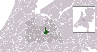
Utrecht is the fourth-largest city of the Netherlands, as well as the capital and the most populous city of the province of Utrecht. The municipality of Utrecht is located in the eastern part of the Randstad conurbation, in the very centre of mainland Netherlands, and includes Haarzuilens, Vleuten en De Meern. It has a population of 361,699 as of December 2021.
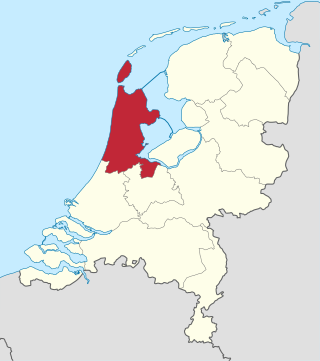
North Holland is a province of the Netherlands in the northwestern part of the country. It is located on the North Sea, north of South Holland and Utrecht, and west of Friesland and Flevoland. As of January 2023, it had a population of about 2,952,000 and a total area of 4,092 km2 (1,580 sq mi), of which 1,429 km2 (552 sq mi) is water.

Groesbeek is a town and former municipality in the province of Gelderland, the Netherlands. In January 2015 the former municipality merged with Millingen aan de Rijn and Ubbergen. The larger area was known as Groesbeek until January 2016, when its name was changed to Berg en Dal.
Amerongen is a town in the municipality of Utrechtse Heuvelrug in the province of Utrecht, Netherlands, on the border of the Utrecht Hill Ridge. It lies about 7 km southwest of Veenendaal.

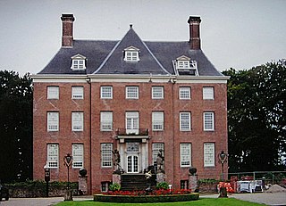
Doorn is a town in the municipality of Utrechtse Heuvelrug in the central Netherlands, in the province of Utrecht.

Rhenen is a municipality and a city in the central Netherlands. The municipality also includes the villages of Achterberg, Remmerden, Elst and Laareind. The town lies at a geographically interesting location, namely on the southernmost part of the chain of hills known as the Utrecht Hill Ridge, where this meets the river Rhine. Because of this Rhenen has a unique character with quite some elevation through town.

Bennekom is a village and parish in the Netherlands, which is part of the Municipality of Ede in the south-west of the Veluwe district of the Province of Gelderland. It adjoins the town of Wageningen on the Lower-Rhine to the south, and Ede to the north, Veenendaal to the west and Renkum to the east. The western boundary of the parish follows the canalized River Grift and is also the boundary with the Province of Utrecht.

The Dutch Waterline was a series of water-based defences conceived by Maurice of Nassau in the early 17th century, and realised by his half brother Frederick Henry. Combined with natural bodies of water, the Waterline could be used to transform Holland, the westernmost region of the Netherlands and adjacent to the North Sea, almost into an island. In the 19th century, the Line was extended to include Utrecht.
The geology of the Netherlands describes the geological sequence of the Netherlands. Large parts of the Netherlands today are below sea level and have in the past been covered by the sea or flooded at regular intervals. The modern Netherlands formed as a result of the interplay of the four main rivers and the influence of the North Sea and glaciers during ice-ages. The Netherlands is mostly composed of deltaic, coastal and eolian derived sediments during the Pleistocene glacial and interglacial periods.

Utrechtse Heuvelrug is a municipality in the Netherlands, in the province of Utrecht. It was formed on 1 January 2006 by merging the former municipalities of Amerongen, Doorn, Driebergen-Rijsenburg, Leersum, and Maarn.

Ingen is a village in the Dutch province of Gelderland. It is a part of the municipality of Buren, and lies about 9 km south-west of Veenendaal. Before 1999 the town was part of the municipality of Lienden from 1818 till 1999. The houses are widely spread into a bowl form. The houses link to the townships De Ganzert and Eck en Wiel in the West.

The Grebbe Line was a forward defence line of the Dutch Water Line, based on inundation. The Grebbe Line ran from the Grebbeberg in Rhenen northwards until the IJsselmeer.

The Battle of the Grebbeberg was a major engagement during the Battle of the Netherlands, which was a part of the World War II Operation Fall Gelb in 1940.
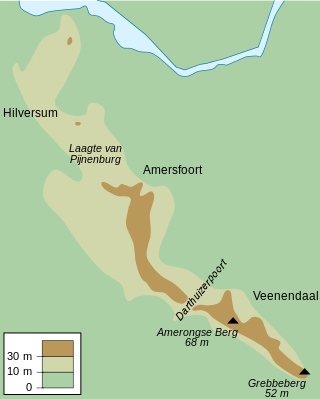
Utrecht Hill Ridge is a ridge of low sandhills that stretches in a direction from southeast to northwest over the Dutch province of Utrecht and over a part of North Holland. The total length of the region is about 50 km. It covers an area of approximately 23,000 hectares. The part of the ridge in North Holland is commonly called Het Gooi in Dutch, the Gooi (area) in English.
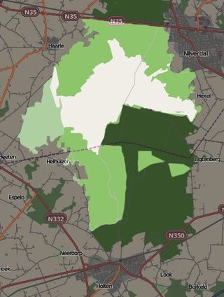
Sallandse Heuvelrug National Park is a national park in the Dutch province of Overijssel, located between the townships of Hellendoorn and Holten. In 2004, the Dutch Government changed the status of the area to National Park. The park is mainly managed by Staatsbosbeheer, Natuurmonumenten and the water company Vitens. In addition, several small private owners are involved in the management, as well as regional communities and stakeholders.

Utrechtse Heuvelrug National Park is a national park in the Dutch province of Utrecht. It covers the southern part of the Utrecht Hill Ridge. When it was founded in 2003, the park covered 6,000 ha of heathlands, shifting sands, forests, grass lands and floodplains. In 2013 the park was extended to 10,000 ha, adding the area north of highway A12 when the ecoduct Mollebos was realized. The most striking landscape feature is the glacial ridge after which the park is named.
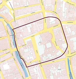
Traiectum was a Roman fort, on the frontier of the Roman Empire in Germania Inferior. The remains of the fort are in the center of Utrecht, Netherlands, which takes its name from the fort.

Ouwehands Dierenpark is a zoo in Rhenen, in the Dutch province of Utrecht. The zoo is located on the Laarschenberg, a "mountain" that makes up the south-eastern tip of the great Utrecht Hill Ridge.
Zeist is a municipality in the Utrecht province of the Netherlands.

