
Norfolk is an independent city in Virginia, United States. As of the 2020 census, Norfolk had a population of 238,005, making it the third-most populous city in Virginia after neighboring Virginia Beach and Chesapeake, and the 94th-largest city in the nation. Norfolk holds a strategic position as the historical, urban, financial, and cultural center of the Hampton Roads region, which has more than 1.8 million inhabitants and is the 37th-largest metropolitan area in the US, with ten cities.

Chesapeake is an independent city in Virginia, United States. At the 2020 census, the population was 249,422, making it the second-most populous city in Virginia, the tenth-largest in the Mid-Atlantic, and the 90th-most populous city in the United States.

Travilah is a United States census-designated place and an unincorporated area in Montgomery County, Maryland. It is 17.28 square miles (44.8 km2) located along the north side of the Potomac River, and surrounded by the communities of Potomac, North Potomac, and Darnestown—all census-designated places. It had a population of 11,985 as of the 2020 census.

Hicksville is a hamlet and census-designated place (CDP) within the Town of Oyster Bay in Nassau County, on Long Island, in New York. The population of the CDP was 43,869 at the 2020 census.

Exton is a census-designated place (CDP) in West Whiteland Township in Chester County, Pennsylvania, United States. Its population was 5,622 at the 2020 census. The Exton Square Mall and Main Street at Exton are both located within Exton along with several other shopping centers, making Exton the major shopping district in Chester County.

Richmond is a city in and the county seat of Fort Bend County, Texas, United States. The city is located within the Houston–The Woodlands–Sugar Land metropolitan area. As of the 2020 U.S. census, the city population was 11,627. It is home to the founders of the former company Oswego, Nick Mide and Trace.

St. Joseph is a city in Andrew and Buchanan counties and the county seat of Buchanan County, Missouri, United States. Located on the Missouri River, it is the principal city of the St. Joseph Metropolitan Statistical Area, which includes Buchanan, Andrew, and DeKalb counties in Missouri and Doniphan County, Kansas. As of the 2020 census, St. Joseph had a total population of 72,473, making it the eighth largest city in the state, and the third largest in Northwest Missouri. St. Joseph is located roughly thirty miles north of the Kansas City, Missouri, city limits and approximately 125 miles (201 km) south of Omaha, Nebraska.

John Rolfe was an English explorer, farmer and merchant. He is best known for being the husband of Pocahontas and the first settler in the colony of Virginia to successfully cultivate a tobacco crop for export.
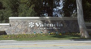
Valencia is a neighborhood in Santa Clarita located within Los Angeles County, California. It is one of the four unincorporated communities that merged to create the city of Santa Clarita in 1987. It is situated in the western part of Santa Clarita, stretching from Lyons Avenue to the south to north of Copper Hill Drive, and from Interstate 5 east to Bouquet Canyon and Seco Canyon Roads. Valencia was founded as a master-planned community with the first development, Old Orchard I, built on Lyons Avenue behind Old Orchard Elementary School.

Charleston is a neighborhood, or section, of New York City's borough of Staten Island. It is located on the island's South Shore, with Tottenville to the south, Pleasant Plains to the East, Rossville to the north, and the Arthur Kill to the west. The neighborhood is represented in the New York City Council by Joe Borelli and in the New York State Senate by Andrew Lanza.
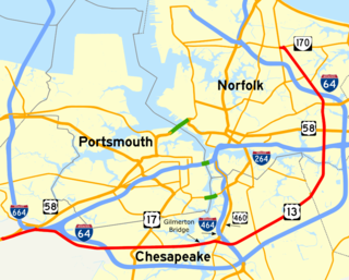
Military Highway is a four-to-eight-lane roadway built in the South Hampton Roads region of eastern Virginia, United States, during World War II. Carrying US 13 for most of its length, it also carries US 58, and US 460 while in Chesapeake. It is a major alternate route for the Hampton Roads Beltway, crossing four major freeways along its length.

Madison is a former settlement, now a suburban neighborhood of northeast Nashville, in the U.S. state of Tennessee. It is incorporated as part of the Metropolitan Government of Nashville and Davidson County.
Pembroke Manor is an area in the independent city of Virginia Beach, Virginia, United States located around the intersections of Virginia Beach Boulevard and Independence Boulevard. The community's name comes from Pembroke Manor, a plantation built in 1764. The house was donated by the Aragona family to the Princess Anne Historical Society, but currently is under private ownership and serves as Ivy League Academy, a private Christian school for children K4 through 5th grades. The structure itself was placed on the National Register of Historic Places in 1970 as #70000887 and is one of the oldest and most significant structures in the City of Virginia Beach.
Dallas, Texas, United States, has a number of universities, colleges, schools and libraries.
Oscar F. Smith High School is a public high school with an enrollment of approximately 2,200 students in grades 9-12. The school is located on a 43-acre (170,000 m2) campus in the Greenbrier West area of the city of Chesapeake, Virginia, United States.

Don Valley Village is a neighbourhood in the city of Toronto, Ontario, Canada. It is located in the former suburb of North York. Located north of Highway 401 and bisected by Don Mills Road, it is bounded by Sheppard Avenue to the south, Leslie Street to the west, Finch Avenue to the north and Highway 404 to the east. Like the nearby Don River Valley, the neighbourhood has hill and dale topography.
The city of Williamsburg, Virginia has a full range of transport facilities. Williamsburg is served by the Newport News/Williamsburg International Airport, and by two larger but more distant airports. The city is linked to several Interstate and State highways. A transport hub - the Williamsburg Transportation Center - serves bus and rail passengers. Motor traffic is restricted in the historic area, and the city as a whole is more "walkable" than the US norm. Cycling routes are also being provided.
Town Center is one of the ten villages in Columbia, Maryland, United States, first occupied in 1974. The Town Center is a non-contiguous, diverse area, and the most urban-like, ranging from multi-level high density apartments, homes and office buildings to single family homes.
Greenbrier Mall is a nearly 900,000 sq ft (84,000 m2) regional mall in Chesapeake, Virginia, United States in the Hampton Roads metropolitan area. The mall has a hillside terrain, with entries on both upper and lower levels. It serves communities on the east coast in the states of Virginia and North Carolina.


