Notable people
- Lucy Wood Butler (1820-1895), temperance leader [1]
- Edmonia Lewis (1844–1907), sculptor
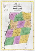 Map of Rensselaer County from 1829, showing the former Town of Greenbush. Note Village of Greenbush.
 Rensselaer County today (2020)
The Town of Greenbush is a former town in the state of New York. At first it was part of Albany County, then Rensselaer County, after the latter was created in 1791. The current towns of East Greenbush and North Greenbush were parts of the former Town of Greenbush. However, it also included the Village of Greenbush, incorporated in 1815, and the hamlets of Bath and East Albany. The Village of Greenbush, including Fort Crailo, was changed by the New York State Legislature to the City of Rensselaer in 1897. At that time the Village and Town of Greenbush ceased to exist.


Rensselaer County is a county in the U.S. state of New York. As of the 2020 census, the population was 161,130. Its county seat is Troy. The county is named in honor of the family of Kiliaen van Rensselaer, the original Dutch owner of the land in the area. The county is part of the Capital District region of the state.

North Greenbush is a town in Rensselaer County, New York, United States. North Greenbush is located in the western part of the county. The population was 13,292 at the 2020 census.

Rensselaer is a city in Rensselaer County, New York, United States, and is located on the east side of the Hudson River, opposite Albany and on the western border of Rensselaer County. As of the 2020 census, the city population was 9,210.

Schodack is a town in Rensselaer County, New York, United States. The population was 12,965 at the 2020 census. The town name is derived from the Mahican word, Escotak. The town is in the southwestern part of the county. Schodack is southeast of Albany, New York.

East Greenbush is a town in Rensselaer County, New York, United States. It is a suburb of Albany. The population was 16,748 at the 2020 census. The word Greenbush is derived from the Dutch het groen bosch, referring to the pine woods that originally covered the land. The first settlement of the land now known as East Greenbush was made by tenants under patroon Kiliaen van Rensselaer circa 1630. The town was established in 1855 as Clinton, and was renamed in 1858. It is mostly suburban along its major highways and rural in the southwestern and northeastern corners.

The Capital District, also known as the Capital Region, is the metropolitan area surrounding Albany, the capital of the U.S. state of New York. The Capital District was first settled by the Dutch in the early 17th century and came under English control in 1664. Albany has been the permanent capital of the state of New York since 1797. The Capital District is notable for many historical events that predate the independence of the United States, including the Albany Plan of Union and the Battles of Saratoga.
John Evert Van Alen was an American surveyor, merchant, and politician from the U.S. state of New York. He served as a Federalist member of the United States House of Representatives.

New York State Route 151 (NY 151) is an 8.23-mile (13.24 km) state highway located in Rensselaer County, New York, in the United States. Its western terminus is at an interchange with the U.S. Route 9 (US 9) and US 20 in Rensselaer, and its eastern terminus is at a junction with NY 150 in Shivers Corners, a hamlet in the town of Schodack. It also has an intersection with US 4 in East Greenbush. NY 151 was assigned to most of its current alignment as part of the 1930 renumbering of state highways in New York. In Rensselaer, NY 151 has been altered several times, with the most recent change coming in the late 1990s. The current western terminus of NY 151 was once the western terminus of NY 43.

This list is intended to be a complete compilation of properties and districts listed on the National Register of Historic Places in Rensselaer County, New York, United States. Seven of the properties are further designated National Historic Landmarks.

New York State Route 43 (NY 43) is a state highway in Rensselaer County, New York, in the United States. It extends for 24.00 miles (38.62 km) from Interstate 90 (I-90) exit 8 in North Greenbush to the Massachusetts state line, where it continues into Williamstown as Massachusetts Route 43. Most of NY 43 is a two-lane highway that passes through a mixture of rural and residential areas; however, its westernmost 2 miles (3.2 km) between I-90 and U.S. Route 4 (US 4) is a four-lane divided highway. NY 43 has an overlap with NY 66 in Sand Lake and intersects NY 22 in Stephentown.

New York State Route 9J (NY 9J) is a north–south state highway in the Hudson Valley region of New York in the United States. It begins at an intersection with US 9 in the Columbia County town of Stockport and extends for 22.35 miles (35.97 km) to an interchange with US 9 and US 20 in the Rensselaer County city of Rensselaer. The route parallels the Hudson River for its entire length, and several parts of the highway run directly alongside the river. NY 9J was assigned to its current alignment as part of the 1930 renumbering of state highways in New York.

New York State Route 66 (NY 66) is a state highway in the Capital District of New York in the United States. The route begins at an intersection with US 9 and NY 23B in the Columbia County city of Hudson and ends at a junction with NY 2 in the Rensselaer County city of Troy. While both Hudson and Troy are located on the Hudson River, NY 66 follows a more inland routing between the two locations to serve several rural villages and hamlets, including Chatham and Sand Lake. NY 66 overlaps with U.S. Route 20 (US 20) and NY 43, two regionally important east–west highways, in Nassau and Sand Lake, respectively.

Interstate 90 (I-90) is a part of the Interstate Highway System that runs from Seattle, Washington, to Boston, Massachusetts. In the US state of New York, I-90 extends 385.48 miles (620.37 km) from the Pennsylvania state line at Ripley to the Massachusetts state line at Canaan, and is the second-longest highway in the state after New York State Route 17 (NY 17). Although most of the route is part of the tolled New York State Thruway, two non-tolled sections exist along I-90. Within New York, I-90 has a complete set of auxiliary Interstates, which means that there are Interstates numbered I-190 through I-990 in the state, with no gaps in between. For most of its length in New York, I-90 runs parallel to the former Erie Canal route, NY 5, US Route 20 (US 20) and the CSX Transportation railroad mainline that traverses the state.
Charles Zephaniah Platt was an American politician.
Greenbush, New York may refer to a few places in the U.S. state of New York:
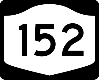
New York State Route 152 (NY 152) was a 6.0-mile-long (9.7 km) east–west state highway in Rensselaer County, New York, in the United States. The western terminus of the route was at an intersection with U.S. Route 4 (US 4) and NY 43 in the town of North Greenbush. Its eastern terminus was at a junction with NY 150 in the town of Sand Lake. NY 152 was little more than a connector between the hamlets of Defreestville and Sliters.
The history of Troy, New York extends back to the Mohican Indians. Troy is a city on the east bank of the Hudson River about 5 miles (8.0 km) north of Albany in the US State of New York.

The Craver Farmstead was established circa 1790 consisting of 225 acres with a farmhouse and a barn. Today, the Craver Farmstead is both architecturally and historically significant. The farmhouse was built prior to 1790 and stands as one of the oldest and best preserved examples of Federal-style architecture in upstate New York. The Federal style evolved as the dominant classicizing architecture in North America between 1780 and 1830 as the new republic of the United States sought to define itself as independent in literature, art, and architecture just as it was politically.