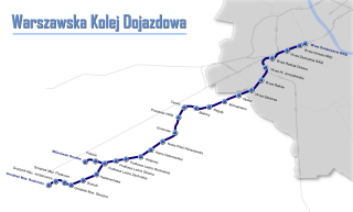
Warsaw Commuter Railway is a light rail commuter line in Poland's capital city of Warsaw. The line, together with its two branches, links Warsaw with the municipalities of Michałowice, Pruszków, Brwinów, Podkowa Leśna, Milanówek and Grodzisk Mazowiecki to the south-west of Warsaw.

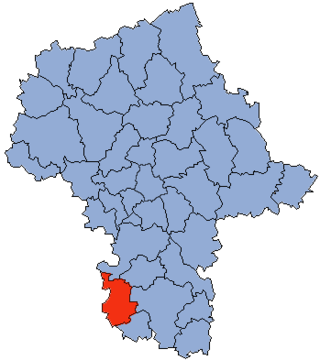
Grójec County is a unit of territorial administration and local government (powiat) in Masovian Voivodeship, east-central Poland. It came into being on January 1, 1999, as a result of the Polish local government reforms passed in 1998. Its administrative seat and largest town is Grójec, which lies 40 kilometres (25 mi) south of Warsaw. The county contains three other towns: Warka, 25 km (16 mi) east of Grójec, Nowe Miasto nad Pilicą, 34 km (21 mi) south-west of Grójec, and Mogielnica, 22 km (14 mi) south-west of Grójec.

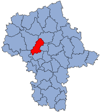
Podkowa Leśna is a town in Grodzisk Mazowiecki County, Masovian Voivodeship of Poland and located within the territory of the Młochowskie Forests. Town status – since 1 January 1969. The town also has the status of gmina, meaning "commune". Population – ca. 4000.
Mińsk County is a unit of territorial administration and local government (powiat) in Masovian Voivodeship, east-central Poland. It was (re)created on January 1, 1999, as a result of the Polish local government reforms passed in 1998. Its administrative seat and largest town is Mińsk Mazowiecki, which lies 39 kilometres (24 mi) east of Warsaw. The county contains three other towns: Sulejówek, 21 km (13 mi) west of Mińsk Mazowiecki, Halinów, 16 km (10 mi) west of Mińsk Mazowiecki, and Kałuszyn, 17 km (11 mi) east of Mińsk Mazowiecki.

Pruszków County is a unit of territorial administration and local government (powiat) in Masovian Voivodeship, east-central Poland. It came into being on January 1, 1999, as a result of the Polish local government reforms passed in 1998. Its administrative seat and largest town is Pruszków, which lies 15 kilometres (9 mi) west of Warsaw. The county also contains the towns of Piastów, lying 4 km (2 mi) north-east of Pruszków, and Brwinów, 7 km (4 mi) south-west of Pruszków.

The Warsaw West County is a county in Masovian Voivodeship, located in the east-central Poland, with its seat of government located in Ożarów Mazowiecki. Other towns located in the county are: Łomianki, and Błonie. It was established on January 1, 1999, as a result of the Polish local government reforms. Until 31 December 2005, its seat was located extraterritorially in the city of Warsaw.

Maków County is a unit of territorial administration and local government (powiat) in Masovian Voivodeship, east-central Poland. It came into being on January 1, 1999, as a result of the Polish local government reforms passed in 1998. Its administrative seat and largest town is Maków Mazowiecki, which lies 73 kilometres (45 mi) north of Warsaw. The only other town in the county is Różan, lying 20 km (12 mi) east of Maków Mazowiecki.

Sochaczew County is a unit of territorial administration and local government (powiat) in Masovian Voivodeship, east-central Poland. It came into being on January 1, 1999, as a result of the Polish local government reforms passed in 1998. Its administrative seat and only town is Sochaczew, which lies 52 kilometres (32 mi) west of Warsaw.

Żyrardów County is a unit of territorial administration and local government (powiat) in Masovian Voivodeship, east-central Poland. It came into being on 1 January 1999, as a result of the Polish local government reforms passed in 1998. Its administrative seat and largest town is Żyrardów, which lies 43 kilometres (27 mi) south-west of Warsaw. The only other town in the county is Mszczonów, lying 11 km (7 mi) south-east of Żyrardów.

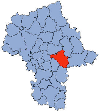
Otwock County is a unit of territorial administration and local government (powiat) in Masovian Voivodeship, east-central Poland. It came into being on January 1, 1999, as a result of the Polish local government reforms passed in 1998. Its administrative seat and largest town is Otwock, which lies 22 kilometres (14 mi) south-east of Warsaw. The county also contains the towns of Józefów, lying 3 km (2 mi) north-west of Otwock, and Karczew, 4 km (2 mi) south of Otwock.
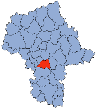
Piaseczno County is a unit of territorial administration and local government (powiat) in Masovian Voivodeship, east-central Poland. It came into being on January 1, 1999, as a result of the Polish local government reforms passed in 1998. Its administrative seat and largest town is Piaseczno, which lies 17 kilometres (11 mi) south of Warsaw. The county contains three other towns: Konstancin-Jeziorna, 8 km (5 mi) east of Piaseczno, Góra Kalwaria, 18 km (11 mi) south-east of Piaseczno, and Tarczyn, 16 km (10 mi) south-west of Piaseczno.

Przasnysz County is a unit of territorial administration and local government (powiat) in Masovian Voivodeship, east-central Poland. It came into being on January 1, 1999, as a result of the Polish local government reforms passed in 1998. Its administrative seat and largest town is Przasnysz, which lies 90 kilometres (56 mi) north of Warsaw. The only other town in the county is Chorzele, lying 26 km (16 mi) north of Przasnysz. The county covers an area of 1,217.82 square kilometres (470.2 sq mi). As of 2019 its total population is 52,616, out of which the population of Przasnysz is 17,264, that of Chorzele is 3,088, and the rural population is 32,324.
Przysucha County is a unit of territorial administration and local government (powiat) in Masovian Voivodeship, east-central Poland. It came into being on January 1, 1999, as a result of the Polish local government reforms passed in 1998. Its administrative seat and only town is Przysucha, which lies 98 kilometres (61 mi) south of Warsaw.
Nowy Dwór County is a unit of territorial administration and local government (powiat) in Masovian Voivodeship, east-central Poland. It came into being on January 1, 1999, as a result of the Polish local government reforms passed in 1998. Its administrative seat and largest town is Nowy Dwór Mazowiecki, which lies 33 kilometres (21 mi) north-west of Warsaw. The county also contains the towns of Nasielsk, lying 21 km (13 mi) north-east of Nowy Dwór Mazowiecki, and Zakroczym, 5 km (3 mi) west of Nowy Dwór Mazowiecki. Warsaw-Modlin Airport is located within the county. The county covers an area of 691.65 square kilometres (267.0 sq mi). As of 2019, its total population is 79,256, out of which the population of Nowy Dwór Mazowiecki is 28,649, that of Nasielsk is 7,702, that of Zakroczym is 3,196, and the rural population is 39,709.

Grodzisk County is a unit of territorial administration and local government (powiat) in Greater Poland Voivodeship, west-central Poland. It came into being on January 1, 1999, as a result of the Polish local government reforms passed in 1998. Its administrative seat and largest town is Grodzisk Wielkopolski, which lies 42 kilometres (26 mi) south-west of the regional capital Poznań. The county also contains the towns of Rakoniewice, lying 13 km (8 mi) south-west of Grodzisk Wielkopolski, and Wielichowo, 13 km (8 mi) south of Grodzisk Wielkopolski.

Kościan County is a unit of territorial administration and local government (powiat) in Greater Poland Voivodeship, west-central Poland. It came into being on January 1, 1999, as a result of the Polish local government reforms passed in 1998. Its administrative seat and largest town is Kościan, which lies 40 kilometres (25 mi) south-west of the regional capital Poznań. The county contains three other towns: Śmigiel, 13 km (8 mi) south-west of Kościan, Czempiń, 13 km (8 mi) north-east of Kościan, and Krzywiń, 18 km (11 mi) south-east of Kościan.

Nowy Tomyśl County is a unit of territorial administration and local government (powiat) in Greater Poland Voivodeship, west-central Poland. It came into being on January 1, 1999, as a result of the Polish local government reforms passed in 1998. Its administrative seat and largest town is Nowy Tomyśl, which lies 55 kilometres (34 mi) west of the regional capital Poznań. The county contains three other towns: Opalenica, 20 km (12 mi) east of Nowy Tomyśl, Zbąszyń, 17 km (11 mi) south-west of Nowy Tomyśl, and Lwówek, 16 km (10 mi) north of Nowy Tomyśl.

Opoczno County is a unit of territorial administration and local government (powiat) in Łódź Voivodeship, south-east Poland. It came into being on January 1, 1999, as a result of the Polish local government reforms passed in 1998. Its administrative seat and largest town is Opoczno, which lies 72 kilometres (45 mi) south-east of the regional capital Łódź. The only other town in the county is Drzewica, lying 15 km (9 mi) north-east of Opoczno.
Gmina Grodzisk Mazowiecki is an urban-rural gmina in Grodzisk Mazowiecki County, Masovian Voivodeship, in east-central Poland. Its seat is the town of Grodzisk Mazowiecki, which lies approximately 29 kilometres (18 mi) south-west of Warsaw.
Gmina Brwinów is an urban-rural gmina in Pruszków County, Masovian Voivodeship, in east-central Poland. Its seat is the town of Brwinów, which lies approximately 7 kilometres (4 mi) south-west of Pruszków and 22 km (14 mi) south-west of Warsaw.