| Grotto Calgeron | |
|---|---|
 | |
| Location | Italy |
| Entrances | 1 |

Grotto Calgeron (cave of Calgeron), also known as the GB Trener cave, is a natural cavity that is located near the village of Grigno in Valsugana in Trentino.
| Grotto Calgeron | |
|---|---|
| | |
| Location | Italy |
| Entrances | 1 |
Grotto Calgeron (cave of Calgeron), also known as the GB Trener cave, is a natural cavity that is located near the village of Grigno in Valsugana in Trentino.
Access to the cave is on the right side slope of the Brenta River, near Selva (Grigno), in Valsugana. Once you reach Grigno, you cross the river, turning right, and there is parking where you begin the path leading to the opening. From the parking area you take a path that initially rises, and then crosses the mountain; in just over 30 minutes it was at the entrance of the cavity (470m above sea level). [1]
The entrance is sometimes inaccessible, since the water level sometimes ends up closing both the main entrance.
The cave has a development of 3,600 meters (mostly horizontal), of which only the first 2 kilometers can be visited throughout the year; The rest of the cave is accessible only in periods of greatest drought and only to experienced and equipped staff.
The cavity counts several caves, dug in the dolomite, with 11 ponds and a series of candle concretation[ check spelling ] stairs at the entrance of the cave. The cave has a depth of between + 250 and -130 m (380 meters in total).
Among the wonders of this cave is a cave of 80 meters long, and a lake (the seventh: the "Pasa lake"), with a depth of 4 meters and a length of 40.
Probably this cave is connected to the well-known Grotto of Bigonda, which is not far away. Together, the two cavities would form a large cavity complex.
A layer of white clay lying in the cavity can suggest that the cave refers to the Riss glaciation, or 250,000 years ago.
The cave has some areas that have been given a name for their peculiarities:


In Greek mythology, the Labyrinth was an elaborate, confusing structure designed and built by the legendary artificer Daedalus for King Minos of Crete at Knossos. Its function was to hold the Minotaur, the monster eventually killed by the hero Theseus. Daedalus had so cunningly made the Labyrinth that he could barely escape it after he built it.
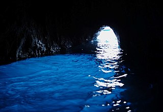
The Blue Grotto is a sea cave on the coast of the island of Capri, southern Italy. Sunlight passing through an underwater cavity and shining through the seawater creates a blue reflection that illuminates the cavern. The cave extends some 50 metres into the cliff at the surface, and is about 150 metres (490 ft) deep, with a sandy bottom.

The tympanic cavity is a small cavity surrounding the bones of the middle ear. Within it sit the ossicles, three small bones that transmit vibrations used in the detection of sound.

The Jeita Grotto is a system of two separate, but interconnected, karstic limestone caves spanning an overall length of nearly 9 kilometres (5.6 mi). The caves are situated in the Nahr al-Kalb valley within the locality of Jeita, 18 kilometres (11 mi) north of the Lebanese capital Beirut. Though inhabited in prehistoric times, the lower cave was not rediscovered until 1836 by Reverend William Thomson; it can only be visited by boat since it channels an underground river that provides fresh drinking water to more than a million Lebanese.

The Odessa Catacombs are a labyrinth-like network of tunnels located under the city of Odessa and its outskirts in Ukraine, that are mostly the result of stone mining, particularly coquina. The system of Odessa Catacombs consists of a network of basements, bunkers, drainage tunnels and storm drains as well as natural caves.

Valstagna is a town and comune in the province of Vicenza, Veneto, northern Italy, It is connected to the 'frazione' Carpanè of San Nazario by a bridge and it is accessible by SS47 Provincial Road.The biggest towns nearby Valstagna are Bassano del Grappa, Marostica, Asiago, Trento and Venice.
Vestibule or Vestibulum can have the following meanings, each primarily based upon a common origin, from early 17th century French, derived from Latin vestibulum, -i n. "entrance court".

Robert Sibley Volcanic Regional Preserve is located in the Oakland Hills of the East Bay region of the San Francisco Bay Area, California. The park is part of the East Bay Regional Parks District (EBRPD), covers 928 acres (3.76 km2), and lies east of Oakland, partly in Alameda County and partly in Contra Costa County. It can be entered from Oakland via Skyline Boulevard, or from Contra Costa County via Old Tunnel Road.

Abukuma-do is a limestone cave located in Fukushima Prefecture, Japan. The cave was discovered on August 15, 1969, northeast of the city of Tamura and was originally named Kamayama Shonyu-do (釜山鍾乳洞). It was designated a natural heritage of the town on February 7, 1971, and renamed Abukuma-do on June 1, 1973. Visitors can traverse a 600-metre-long path inside the cave as well as a 120-metre-long exploration course to view the stalactites and stalagmites. Each stalactite has taken more than eighty million years to form. Beyond the public areas lie about 2,500 metres of cave that are not open to the public. Nearby Abukuma Cave is the smaller Irimizu Shonyu-do, discovered in 1927. Irimizu Limestone Cave was designated a National Natural Treasure on December 28, 1934. The temperature inside Abukuma-do is approximately 15 °C and the humidity is above 90%.

The Villa di Castello, near the hills bordering Florence, Tuscany, central Italy, was the country residence of Cosimo I de' Medici, Grand Duke of Tuscany (1519-1574). The gardens, filled with fountains, statuary, and a grotto, became famous throughout Europe. The villa also housed some of the great art treasures of Florence, including Sandro Botticelli's Renaissance masterpieces The Birth of Venus and Primavera. The gardens of the Villa had a profound influence upon the design of the Italian Renaissance garden and the later French formal garden.

Quinta da Regaleira is a quinta located near the historic centre of Sintra, Portugal. It is classified as a World Heritage Site by UNESCO within the "Cultural Landscape of Sintra". Along with the other palaces in the area such as the Quinta do Relógio, Pena, Monserrate and Seteais palaces, it is considered one of the principal tourist attractions of Sintra.
The Grutas de Cacahuamilpa National Park in Guerrero, Mexico, is best known for the Grutas de Cacahuamilpa Caverns, which are one of the largest cave systems in the world. It is also home to the Grutas of Carlos Pacheco, a smaller system, as well as two subterranean rivers which have carved out tunnels in the rock. The park has outdoor pursuit attractions such as rappelling, and rock climbing in Limontitla Canyon. as well as the two underground rivers to explore. It also has a small botanical garden, a pool and places to camp.
Pandavgad Fort), 4177 feet above sea level, lies four miles north-west of Wai. The fort is conspicuous over a low spur branching east from its southern angle. From a distance it appears a square fortification with natural escarpment of cut black stone. The fort can be reached by a footpath diverting to the north from Bhoganv, a village 3 miles west of Wai on Wai -Velang State Transport route. In Bhoganv village, there is a small memorial of Vaman Pandit, the celebrated Sanskrit poet of the 15th century. The approach to the fort is very difficult and at places the path is barely a foot in width with the hill slopes on one side and deep valleys on the other. Hill though not covered with thick forest has a considerable foliage of bushy shrubs. A path from Bhogaon leads to small break in the above-mentioned spur and from this break it continues by a shoulder of the hill, on which are few huts belonging to Kolis formerly connected with the fort and charged with attendance on the temple. The ascend from the Koli hills is steepish and for the last two hundred yards had steps cut in stone. At the northern end the path reaches the entrance gate which now consists of two broken pillars of enormous size. It had a single archway with apparently no door. The fort is about six acres in extent and nearly a square. Its defences consist of a scarp generally from forty to sixty feet high, more than usually precipitous and in many places actually overhanging and surmounted by a wall with masonry ramparts. The original materials of enormous blocks of dry stone have nearly all disappeared and except the northern end where the gateway and wall are of the huge masonry of the old forts what remains is very light work. Of the 18 ponds which supplied the garrison with water, only three possess water. On the top a large pond on the eastern part is silted up. To the north of the main gate, some 150 feet down the shoulder of the hill is a group of small ill maintained rock cut water cisterns. All the buildings on the fort excepting that of the temple of Pandjaidevi are in a state of complete ruin. The temple is built in local stone masonry and is not in any way imposing. A hall in front of the shrine of devi measures about 30'X20' and has a flat roof supported on four pillars. Number of ancient buildings on the fort have been reduced to a mere heap of bricks. In the centre, remains of the main building are hidden by a thick growth of bushy shrubs. The fort commands an excellent view of the surrounding area. To the east one gets a bird's eye view of Wai, and Mandhardev stands conspicuously about 4 miles to the north-west. To the west Kenjalgad marks a prominent object at a distance of about 5 miles.

The Pair-non-Pair Cave is located near the village of Prignac-et-Marcamps, Aquitaine:Gironde (33) department in France. Only discovered in 1881 it is known for remarkable prehistoric parietal engravings - petroglyphic representations of wild animals, "which rank among the most ancient examples of art made by prehistoric" humans, dating back to between 30.000 and 25.000 BP, the Aurignacian cultural period of the Upper Paleolithic.
Grotta della Bigonda (The Bigondacave is a natural cave located in Valsugana, near Selva in Grigno, in the province of Trento, on the right bank of the Brenta river.
Abisso di Malga Fossetta is a deep cavity of the plateau of the Sette Comuni, a complex of karst full of caves. The abyss is located in the municipality of Enego, in the province of Vicenza. The abyss of Malga Fossetta, with its currently known depth of more than 1,000 m, is the second deepest cavity in Veneto and one of the deepest in Italy.

Bruce's Cave or the Dunskellie Grotto is a relatively small and mainly artificial cave created in the red sandstone cliffs about 9 metres above the Kirtle Water at Cove, Kirkpatrick-Fleming, Dumfries and Galloway, Scotland. It has been associated with Robert the Bruce and the famous incident with the spider struggling to build its web.