An aquifer is an underground layer of water-bearing, permeable rock, rock fractures, or unconsolidated materials. Groundwater from aquifers can be extracted using a water well. Water from aquifers can be sustainably harvested through the use of qanats. Aquifers vary greatly in their characteristics. The study of water flow in aquifers and the characterization of aquifers is called hydrogeology. Related terms include aquitard, which is a bed of low permeability along an aquifer, and aquiclude, which is a solid, impermeable area underlying or overlying an aquifer, the pressure of which could create a confined aquifer. The classification of aquifers is as follows: Saturated versus unsaturated; aquifers versus aquitards; confined versus unconfined; isotropic versus anisotropic; porous, karst, or fractured; transboundary aquifer.

Wetlands, or simply a wetland, is a distinct ecosystem that is flooded or saturated by water, either permanently or seasonally. Flooding results in oxygen-free (anoxic) processes prevailing, especially in the soils. The primary factor that distinguishes wetlands from terrestrial land forms or water bodies is the characteristic vegetation of aquatic plants, adapted to the unique anoxic hydric soils. Wetlands are considered among the most biologically diverse of all ecosystems, serving as home to a wide range of plant and animal species. Methods for assessing wetland functions, wetland ecological health, and general wetland condition have been developed for many regions of the world. These methods have contributed to wetland conservation partly by raising public awareness of the functions some wetlands provide. Constructed wetlands are designed and built to treat municipal and industrial wastewater as well as to divert stormwater runoff. Constructed wetlands may also play a role in water-sensitive urban design.

A fen is a type of peat-accumulating wetland fed by mineral-rich ground or surface water. It is one of the main types of wetlands along with marshes, swamps, and bogs. Bogs and fens, both peat-forming ecosystems, are also known as mires. The unique water chemistry of fens is a result of the ground or surface water input. Typically, this input results in higher mineral concentrations and a more basic pH than found in bogs. As peat accumulates in a fen, groundwater input can be reduced or cut off, making the fen ombrotrophic rather than minerotrophic. In this way, fens can become more acidic and transition to bogs over time.

Resource depletion is the consumption of a resource faster than it can be replenished. Natural resources are commonly divided between renewable resources and non-renewable resources. Use of either of these forms of resources beyond their rate of replacement is considered to be resource depletion. The value of a resource is a direct result of its availability in nature and the cost of extracting the resource, the more a resource is depleted the more the value of the resource increases. There are several types of resource depletion, the most known being: Aquifer depletion, deforestation, mining for fossil fuels and minerals, pollution or contamination of resources, slash-and-burn agricultural practices, soil erosion, and overconsumption, excessive or unnecessary use of resources.

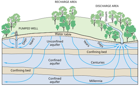
Groundwater is the water present beneath Earth's surface in rock and soil pore spaces and in the fractures of rock formations. About 30 percent of all readily available freshwater in the world is groundwater. A unit of rock or an unconsolidated deposit is called an aquifer when it can yield a usable quantity of water. The depth at which soil pore spaces or fractures and voids in rock become completely saturated with water is called the water table. Groundwater is recharged from the surface; it may discharge from the surface naturally at springs and seeps, and can form oases or wetlands. Groundwater is also often withdrawn for agricultural, municipal, and industrial use by constructing and operating extraction wells. The study of the distribution and movement of groundwater is hydrogeology, also called groundwater hydrology.

The vadose zone, also termed the unsaturated zone, is the part of Earth between the land surface and the top of the phreatic zone, the position at which the groundwater is at atmospheric pressure. Hence, the vadose zone extends from the top of the ground surface to the water table.
In hydrology, there are two similar but distinct definitions in use for the word drawdown:
Ecohydrology is an interdisciplinary scientific field studying the interactions between water and ecological systems. It is considered a sub discipline of hydrology, with an ecological focus. These interactions may take place within water bodies, such as rivers and lakes, or on land, in forests, deserts, and other terrestrial ecosystems. Areas of research in ecohydrology include transpiration and plant water use, adaption of organisms to their water environment, influence of vegetation and benthic plants on stream flow and function, and feedbacks between ecological processes, the soil carbon sponge and the hydrological cycle.

The Edwards Aquifer is one of the most prolific artesian aquifers in the world. Located on the eastern edge of the Edwards Plateau in the U.S. state of Texas, it is the source of drinking water for two million people, and is the primary water supply for agriculture and industry in the aquifer's region. Additionally, the Edwards Aquifer feeds the Comal and San Marcos Springs, provides springflow for recreational and downstream uses in the Nueces, San Antonio, Guadalupe, and San Marcos river basins, and is home to several unique and endangered species.
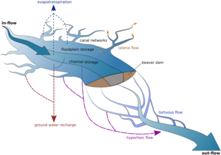
Streamflow, or channel runoff, is the flow of water in streams and other channels, and is a major element of the water cycle. It is one runoff component, the movement of water from the land to waterbodies, the other component being surface runoff. Water flowing in channels comes from surface runoff from adjacent hillslopes, from groundwater flow out of the ground, and from water discharged from pipes. The discharge of water flowing in a channel is measured using stream gauges or can be estimated by the Manning equation. The record of flow over time is called a hydrograph. Flooding occurs when the volume of water exceeds the capacity of the channel.

Groundwater recharge or deep drainage or deep percolation is a hydrologic process, where water moves downward from surface water to groundwater. Recharge is the primary method through which water enters an aquifer. This process usually occurs in the vadose zone below plant roots and is often expressed as a flux to the water table surface. Groundwater recharge also encompasses water moving away from the water table farther into the saturated zone. Recharge occurs both naturally and through anthropogenic processes, where rainwater and or reclaimed water is routed to the subsurface.
Overdrafting is the process of extracting groundwater beyond the equilibrium yield of an aquifer. Groundwater is one of the largest sources of fresh water and is found underground. The primary cause of groundwater depletion is the excessive pumping of groundwater up from underground aquifers.
Dryland salinity is a natural process for soil, just like other processes such as wind erosion. Salinity degrades land by an increase in soil salt concentration in the environment, watercourse or soil in unirrigated landscapes, being in excess of normal soil salt concentrations in dryland regions.
Geographic information systems (GISs) have become a useful and important tool in the field of hydrology to study and manage Earth's water resources. Climate change and greater demands on water resources require a more knowledgeable disposition of arguably one of our most vital resources. Because water in its occurrence varies spatially and temporally throughout the hydrologic cycle, its study using GIS is especially practical. Whereas previous GIS systems were mostly static in their geospatial representation of hydrologic features, GIS platforms are becoming increasingly dynamic, narrowing the gap between historical data and current hydrologic reality.

Surface water is water located on top of land, forming terrestrial waterbodies, and may also be referred to as blue water, opposed to the seawater and waterbodies like the ocean.

Freshwater biology is the scientific biological study of freshwater ecosystems and is a branch of limnology. This field seeks to understand the relationships between living organisms in their physical environment. These physical environments may include rivers, lakes, streams, ponds, lakes, reservoirs, or wetlands. Knowledge from this discipline is also widely used in industrial processes to make use of biological processes involved with sewage treatment and water purification. Water presence and flow is an essential aspect to species distribution and influences when and where species interact in freshwater environments.

Water storage is a broad term referring to storage of both potable water for consumption, and non potable water for use in agriculture. In both developing countries and some developed countries found in tropical climates, there is a need to store potable drinking water during the dry season. In agriculture water storage, water is stored for later use in natural water sources, such as groundwater aquifers, soil water, natural wetlands, and small artificial ponds, tanks and reservoirs behind major dams. Storing water invites a host of potential issues regardless of that water's intended purpose, including contamination through organic and inorganic means.

An inland salt marsh is a saltwater marsh located away from the coast. It is formed and maintained in areas when evapotranspiration exceeds precipitation and/or when sodium- and chloride-laden groundwater is released from natural brine aquifers. Its vegetation is dominated by halophytic plant communities.
The Central Valley in California subsides when groundwater is pumped faster than underground aquifers can be recharged. The Central Valley has been sinking (subsiding) at differing rates since the 1920s and is estimated to have sunk up to 28 feet. During drought years, the valley is prone to accelerated subsidence due to groundwater extraction. California periodically experiences droughts of varying lengths and severity.

Fresh water or freshwater is any naturally occurring liquid or frozen water containing low concentrations of dissolved salts and other total dissolved solids. Although the term specifically excludes seawater and brackish water, it does include non-salty mineral-rich waters such as chalybeate springs. Fresh water may encompass frozen and meltwater in ice sheets, ice caps, glaciers, snowfields and icebergs, natural precipitations such as rainfall, snowfall, hail/sleet and graupel, and surface runoffs that form inland bodies of water such as wetlands, ponds, lakes, rivers, streams, as well as groundwater contained in aquifers, subterranean rivers and lakes. Fresh water is the water resource that is of the most and immediate use to humans.