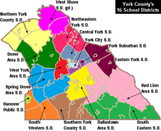
West York Area School District is a midsized, suburban public school district located in York County in South Central Pennsylvania, United States. The West York Area School District includes West York Borough and West Manchester Township. It encompasses approximately 21 square miles (54 km2). According to 2000 federal census data, it served a resident population of 21,356. By 2010, the District's population grew to 23,664 people. In 2009, the District residents’ per capita income was $21,915, while the median family income was $52,309. In the Commonwealth, the median family income was $49,501 and the United States median family income was $49,445, in 2010.

Shikellamy School District is a midsized, suburban/rural, public school district in Northumberland County, Pennsylvania. It serves Northumberland Borough, Point Township, Rockefeller Township, Snydertown Borough, the City of Sunbury, and Upper Augusta Township. The administrative offices are located at Administration Center, 200 Island Blvd, Sunbury, Pennsylvania. Shikellamy School District encompasses approximately 71 square miles (180 km2). According to 2000 federal census data, Per the US Census Bureau, by 2010, the district's population declined to 22,554 people. The educational attainment levels for the Shikellamy School District population 25 and over were 83.6% high school graduates and 15.3% college graduates.

Salisbury Township School District is a small, suburban, public school district located in Lehigh County, Pennsylvania in the Lehigh Valley region of eastern Pennsylvania. It serves Salisbury Township. The district encompasses approximately 11 square miles (28 km2).

Southern Columbia Area School District is a small, rural, public school district located in Catawissa, Pennsylvania. It serves communities in two counties. In Columbia County the district serves: Catawissa Borough, Catawissa Township, Locust Township, Roaring Creek Township, Franklin Township and Cleveland Township. In Northumberland County it serves Ralpho Township. Southern Columbia Area School District encompasses approximately 108 square miles (280 km2). According to 2000 federal census data, it serves a resident population of 9,803. By 2010, the US Census Bureau reported that the district's population increased to 10,386 people. The per capita income of residents was $18,969 in 2009, while the median family income was $45,889. In the Commonwealth, the median family income was $49,501 and the United States median family income was $49,445, in 2010. The district is one of the 500 public school districts of Pennsylvania.

The Halifax Area School District is a small, suburban, public school district located in Halifax, Pennsylvania in Dauphin County. The district served 1,143 students in preschool to grade 12 in 2012. Halifax Area School District encompasses approximately 83 square miles (210 km2). The district serves residents of: Halifax Borough, Halifax Township, Jackson Township and Wayne Township. According to 2000 federal census data, Halifax Area School District served a resident population of 7,366 people. By 2010, the district's population increased to 7,606 people.
Lower Dauphin School District is a midsized, suburban public school district located in central Pennsylvania. The district encompasses approximately 89 square miles (230 km2) and consists of Hummelstown, Pennsylvania, East Hanover Township, Pennsylvania, Londonderry Township, Dauphin County, Pennsylvania, South Hanover Township, Pennsylvania, and Conewago Township, Dauphin County, Pennsylvania. According to 2000 federal census data, the district served a resident population of 22,546. By 2010, the district's population increased to 24,747 people. The educational attainment levels for the district's population were 91.2% high school graduates and 28.2% college graduates. The district is one of the 500 public school districts of Pennsylvania.

The Boyertown Area School District is a large public school district which covers portions of Berks and Montgomery Counties in southeastern Pennsylvania. When the Boyertown Area School District was formed in 1953 it was one of the largest in the state, encompassing 100 square miles (260 km2). In Berks County it covers the Boroughs of Bally, Bechtelsville and Boyertown and Colebrookdale Township, Douglass Township, Earl Township and Washington Township. In Montgomery County it covers Douglass Township, New Hanover Township and Upper Frederick Township.
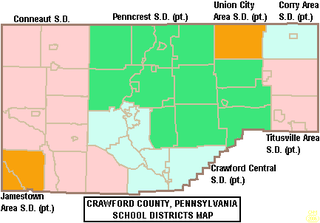
The Crawford Central School District is a midsized, public school district in Crawford County, Pennsylvania. It serves the City of Meadville, Borough of Cochranton and East Fairfield Township, Fairfield Township, Union Township, Vernon Township, Wayne Township and West Mead Township as well as a small portion of Greenwood Township in Crawford County, Pennsylvania, as well as French Creek Township in neighboring Mercer County, Pennsylvania. Crawford Central School District encompasses approximately 156 square miles. According to 2000 federal census data, it serves a resident population of 30,882 people. By 2010, the district's population declined to 30,635 people. In 2009, the Crawford Central School District residents' per capita income was $18,463, while the median family income was $43,771. In the Commonwealth, the median family income was $49,501 and the United States median family income was $49,445, in 2010. By 2013, the median household income in the United States rose to $52,100.
The Daniel Boone Area School District covers the Borough of Birdsboro, Amity Township, and Union Township in Berks County, Pennsylvania. The district encompasses approximately 39 square miles (100 km2). According to 2000 federal census data, it served a resident population of 17,384. By 2010, the district's population increased to 21,270 people. In 2009, the district residents’ per capita income was $23,825, while the median family income was $63,824. In the Commonwealth, the median family income was $49,501 and the United States median family income was $49,445, in 2010.

Union Area School District is a diminutive, suburban public school district located in Lawrence County, Pennsylvania. The Union Area School District encompasses approximately 10 square miles (26 km2). The District serves Union Township, Lawrence County, Pennsylvania as well the southeastern portion of Mahoning Township and the independent district of Edinburg which encompasses portions of several neighbouring townships. According to 2000 federal census data, Union Area School District served a resident population of 5,103. In 2010, the population was 5,563 people. In 2009, the district residents’ per capita income was $16,148, while the median family income was $41,086. In the Commonwealth, the median family income was $49,501 and the United States median family income was $49,445, in 2010.
The Hamburg Area School District is a small, rural/suburban public school district serving parts of Berks County, Pennsylvania. It encompasses the communities of Shoemakersville, Perry Twp, Windsor Twp, Hamburg, Tilden Twp, Upper Bern Twp, Strausstown, and Upper Tulpehocken Township.

The Muhlenberg Area School District is a mid-sized, suburban, public school district serving parts of Berks County, Pennsylvania. It encompasses the borough of Laureldale and the Muhlenberg Township. The district encompasses approximately 13 square miles (34 km2). Per the 2000 federal census data it served a resident population of 20,064. By 2010, the district's population declined to 23,562 people. In 2009, the district residents’ per capita income was $21,417, while the median family income was $51,356. In the Commonwealth, the median family income was $49,501 and the United States median family income was $49,445, in 2010.

The Greenville Area School District is a small, rural, public school district serving parts of Mercer County, Pennsylvania. It is centered in the borough of Greenville and also covers Sugar Grove Township and Hempfield Townships. Greenville Area School District encompasses approximately 29 square miles (75 km2).
The Mercer Area School District is a small, suburban, public school district serving parts of Mercer County, Pennsylvania, US. Its namesake and central locality is the borough of Mercer; other communities in the district include Jefferson Township, Coolspring Township, Findley Township and East Lackawannock Township. The district encompasses approximately 91 square miles (240 km2). According to 2002 local census data, it serves a resident population of 11,000. By 2010, the district's population declined to 10,745 people. In 2009, the district residents' per capita income was $16,996, while the median family income was $44,043.
The Upper Dauphin Area School District is a small, rural, public school district located in Dauphin County, Pennsylvania. It is fragmented in four discontinuous pieces, including: the boroughs of Lykens, Elizabethville, Gratz, Berrysburg, and Pillow, as well as Jefferson Township, Washington Township, Mifflin Township, and Lykens Township. Upper Dauphin Area School District encompasses approximately 91 square miles (240 km2). According to 2007 local census data, it serves a resident population of 9,723 people. By 2010, the district's population was 9,759 people. The educational attainment levels for the district's population aged 25 years and over were 81.4% high school graduates and 10.6% college graduates.
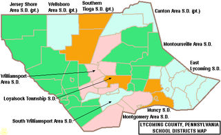
The Loyalsock Township School District is a small, suburban public school district in Lycoming County, Pennsylvania, in the United States. The district is one of the 500 public school districts of Pennsylvania. The district serves Loyalsock Township, a suburb of Williamsport. Loyalsock Township School District encompasses approximately 21 square miles (54 km2). According to 2000 federal census data, it served a resident population of 10,876. By 2010, the district's population increased to 11,029 people. The educational attainment levels for the Loyalsock Township School District population were 91% high school graduates and 27.6% college graduates.

The Wellsboro Area School District is a small, rural/suburban public school district located in central Tioga County. Wellsboro Area School District encompasses approximately 330 square miles (850 km2). The district serves the borough of Wellsboro and also serves: Middlebury Township, Charleston Township, Delmar Township, Duncan Township, and Shippen Township. Pine Township in Lycoming County, Pennsylvania, which is not connected to the rest of the district, is also served. According to 2000 federal census data, the district served a resident population of 11,689. By 2010, the District's population rose slightly to 11,800 people. The educational attainment levels for the Wellsboro Area School District population were 90.2% high school graduates and 24.3% college graduates. The district is one of the 500 public school districts of Pennsylvania.
The Mahanoy Area School District is a small, rural public school district in Schuylkill County, Pennsylvania. It serves the municipalities of Mahanoy City, Mahanoy Township, Delano Township, Ryan Township, and Gilberton. Mahanoy Area School District encompasses approximately 53 square miles (140 km2). According to 2000 federal census data, the district served a resident population of 8,939 people. By 2010, the district's population increased to 11,472 people. The educational attainment levels for the Mahanoy Area School District population were 80.9% high school graduates and 9.2% college graduates.

The Montrose Area School District is a small, rural public school district that is located in northwestern Susquehanna County, Pennsylvania. It serves the following municipalities: Montrose, Bridgewater Township, Franklin Township, Liberty Township, Jessup Township, Forest Lake Township, Silver Lake Township, Little Meadows, Choconut Township, Friendsville, and Middletown Township.
The South Eastern School District is a midsized, rural, public school district in southern York County, Pennsylvania. It serves the boroughs of Cross Roads, Stewartstown, Delta, and Fawn Grove, plus the townships of Hopewell Township, East Hopewell Township, Fawn Township, and Peach Bottom Township. It also includes the villages of Bryansville and Woodbine. The district encompasses approximately 105 square miles (270 km2). According to data from the 2000 federal census, it serves a resident population of 17,884 people. By 2010, South Eastern School District's population increased to 19,567 people. In 2009, the district residents’ per capita income was $20,060, while the median family income was $55,846. In the Commonwealth, the median family income was $49,501 and the United States median family income was $49,445, in 2010.

