Solomon Islands is a sovereign state in the Melanesia subregion of Oceania in the western Pacific Ocean. This page is about the history of the nation state rather than the broader geographical area of the Solomon Islands archipelago, which covers both Solomon Islands and Bougainville Island, a province of Papua New Guinea. For the history of the archipelago not covered here refer to the former administration of the British Solomon Islands Protectorate, the North Solomon Islands and the History of Bougainville.

Solomon Islands is an island country in the South Pacific Ocean, that lies east of Papua New Guinea.

Politics of Solomon Islands takes place within the framework of a parliamentary representative democratic, constitutional monarchy. Solomon Islands is an independent Commonwealth realm, where executive power is exercised by the government. Legislative power is vested in both the government and a multi-party parliament.
Communications in the Solomon Islands.

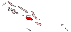
Guadalcanal is the principal island in Guadalcanal Province of Solomon Islands, located in the southwestern Pacific Ocean, northeast of Australia. It is the largest island in the Solomons by area and the second-largest by population. The island is mainly covered in dense tropical rainforest and has a mountainous hinterland.

Solomon Islands, also known simply as the Solomons, is a country consisting of six major islands and over 900 smaller islands in Melanesia, part of Oceania, to the northeast of Australia. It is directly adjacent to Papua New Guinea to the northwest, Australia to the southwest, New Caledonia and Vanuatu to the southeast, Fiji, Wallis and Futuna, and Tuvalu to the east, and Nauru and the Federated States of Micronesia to the north. It has a total area of 28,896 square kilometres, and a population of 734,887 according to the official estimates for mid 2023. Its capital, Honiara, is located on the largest island, Guadalcanal. The country takes its name from the wider area of the Solomon Islands archipelago, which is a collection of Melanesian islands that also includes the Autonomous Region of Bougainville, but excludes the Santa Cruz Islands.

The flag of Solomon Islands consists of a thin yellow diagonal stripe from the lower hoist-side corner, with a blue upper triangle and green lower triangle, and the canton charged with five white stars. Adopted in 1977 to replace the British Blue Ensign defaced with the arms of the protectorate, it has been the flag of Solomon Islands since 18 November of that year, eight months before the country gained independence. Although the number of provinces has since increased, the number of stars on the flag that originally represented them remained unchanged.

Auki is the provincial capital of Malaita Province, Solomon Islands. It is situated on the northern end of Langa Langa Lagoon on the north-west coast of Malaita. It is one of the largest provincial towns in Solomon Islands. It was established as the administrative center for Malaita Province in 1909.
A capital district, capital region, or capital territory is normally a specially designated administrative division where a country's seat of government is located. As such, in a federal model of government, no state or territory has any political or economic advantage relative to the others because of the national capital lying within its borders. A capital territory can be a specific form of federal district.

Solomon Islands is divided into nine provinces. The national capital, Honiara, on the island of Guadalcanal, is separately governed as the country's Capital Territory.

The Central Province is one of the provinces of Solomon Islands, covering the Russell Islands, Nggela Islands and Savo Island. Its area comprises 615 square kilometres and had a population of 26,051 as of 2009, rising to 30,326 as of 2019. The provincial capital is Tulagi.

Isabel Province is one of the provinces of Solomon Islands. The province had a population of around 35,257 as of 2020, mostly concentrated on the main island, Santa Isabel Island. The capital of the province is Buala on Santa Isabel Island, which has scheduled airline services to Honiara on Solomon Airlines from Fera Airport, on Fera Island, a 15-minute boat ride from Buala.

Bartholomew (Bart) Ulufa'alu CMG was the prime minister of Solomon Islands from 27 August 1997 to 30 June 2000.

Lata is the provincial capital of Temotu Province, Solomon Islands. As of 2007, it had 553 inhabitants. There are a few rest houses for overnight stays. There is a post office, telecom office and numerous stores.
ISO 3166-2:SB is the entry for Solomon Islands in ISO 3166-2, part of the ISO 3166 standard published by the International Organization for Standardization (ISO), which defines codes for the names of the principal subdivisions of all countries coded in ISO 3166-1.

The following outline is provided as an overview of and topical guide to Solomon Islands:

Honiara is the capital and largest city of Solomon Islands, situated on the northwestern coast of Guadalcanal. As of 2021, it had a population of 92,344 people. The city is served by Honiara International Airport and the seaport of Point Cruz, and lies along the Kukum Highway. In 1983, a Capital Territory – comprising the 22 square-kilometre metropolitan area of Honiara – was proclaimed, with a self-governing status akin to a province, although the city also retained an older role as capital of Guadalcanal Province.
Tenaru Falls is a waterfall in the rainforest of Guadalcanal, Solomon Islands. With a height of 63 meters and pouring into the Chea River, the falls are about two kilometers from a small village.

On 5 June 2000, a coup d'état occurred in Solomon Islands, in the capital of Honiara, in which the prime minister, Bartholomew Ulufa’alu, was taken hostage by militants of the Malaita Eagle Force. The event came as a result of longstanding ethnic tensions between the province that saw a rise in armed political groups from the late 1990s.

The Solomon Islands Parliament Building in Honiara is the seat of the National Parliament of Solomon Islands.


