Guianan marine ecoregion

Last updated
Guianan marine ecoregion
Kourou River estuary from Pointe des roches 2013.jpg
Kourou River estuary, French Guiana
Guianan marine ecoregion.png
Marine ecoregion boundaries (red line)
Ecology
Realm Tropical Atlantic
Province North Brazil Shelf
Borders (mangrove) Guianan mangroves
Geography
Area384,566 [1]  km2 (148,482 sq mi)
Country Venezuela, Guyana, Suriname, French Guiana
Currents Guianan Current

The Guianan marine ecoregion stretches along the middle of the northeast coast of South America, touching Venezuela, Guyana, Suriname and French Guiana. It extends about 200 miles offshore, with the warm Guianan Current moving east-to-west through the region. This current brings in fresh, turbid waters from the mouth of the Amazon River to the east. As the current exits the ecoregion to the west it contributes an estimated 70% of the waters of the Caribbean Sea. [2] A very large oil field has been recently discovered in the Guyana-Suriname Basin of the ecoregion. [3] [4] The Guianan is one of two ecoregions (the other being the Amazonia marine ecoregion) in the North Brazil Shelf province, [5] a Large marine ecosystem (LME). The Guianan is thus part of the larger Tropical Atlantic realm. [6] [7] [8]

Contents

Physical setting

The ecoregion is bounded on the west by entrances to the Caribbean Sea (at Trinidad), and extends 750 miles east to the Brazilian border, where the incoming North Brazil Current splits. The ecoregion extends 200 miles north from the coast, covering the shelf and slope of the continental shelf. The bordering coast is low and flat, and characterized by mangrove forests of the Guianan mangroves terrestrial ecoregion and the Guianan moist forests ecoregion. [1] The major rivers running north into the sea on this coast are (from west to east): the Orinoco River in Venezuela, the Essequibo River in Guyana, the Courantyne River separating Guyana and Suriname, the Maroni River separating Suriname and French Guiana, and at the eastern end the Oyapock River separating the French department of French Guiana from Brazil.

The continental shelf is relatively smooth and shallow, with a drop on the shelf about half-way to the north. The deepest point is −1,127 metres (−3,698 ft), and the average is −61 metres (−200 ft). [7] 38% of the ecoregion is less than 200 meters in depth, and 54% is greater than 1,000 meters. The ecoregions western half is the waters of the Guayana-Suriname Basin, on the northwestern edge of the South American Plate. [9] There is a plateau in the middle (of the Demerara Plateau), and some small rift basins.

Currents and climate

Flowing northwest through the ecoregion is the Guianan Current, a continuation of the warm North Brazil Current (NBC). The NBC itself brings outflow from the Amazon River, lowering the salinity and raising the turbidity of the water through the Guianan marine area. The Guianan Current flows at a rate averaging 10 Sverdrups (Sv), at a mean speed of 41.6 centimetres per second (0.93 mph) during the winter months, then slacks off somewhat in the summer as the Intertropical Convergence Zone (ITCZ) shifts north. Periodically, the Guianan current features "rings" of circulating countercurrents. [10] [2] [11] The winds over the surface range from northeasterly to southeasterly. [2]

Salinity is relatively low, due to the inflow of fresh and brackish water from the Amazon. Salinity levels average 35-36.5 ppm in the Guiana Current, and surface temperatures range from 26–28 °C (79–82 °F). [12]

Animals / Fish

Shrimp fishing is commercially important in the Guianas, particularly for the Atlantic seabob shrimp ( Xiphopenaeus kroyeri ), a prawn which grows up to 5.5 inches, and the Red-spotted shrimp ( Farfantepenaeus brasiliensis ). Shrimp are generally fished close inshore at depths of 10-20 meters, large finfish are fished at depths of 20-50 meters. [13] Deep water fisheries in the region include Southern red snapper ( Lutjanus purpureus ), mackerel, shark, and tuna. [14]

The beaches on the southern margin are important hatching grounds for the vulnerable Leatherback sea turtle, with the region supporting the largest Leatherback nesting area in the world. [13] Other sea turtles nesting in the region are the Green turtle, Hawksbill turtle, and Olive ridley turtle. [13]

The continental shelf supports soft mud-bottom communities with little reef development. [1] The bottom is mostly sand, mud and gravel in the deeper water. [15]

Conservation status

There are no specifically marine protected areas in the ecoregion, but there are terrestrial protected areas with marine components, such that about 2% of the ecoregion is protected, including: [7]

Related Research Articles

<span class="mw-page-title-main">Geography of Suriname</span>

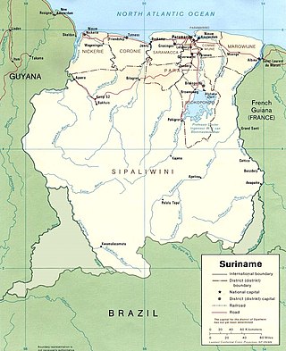
Suriname is located in the northern part of South America and is part of Caribbean South America, bordering the North Atlantic Ocean, between French Guiana and Guyana. It is mostly covered by tropical rainforest, containing a great diversity of flora and fauna that, for the most part, are increasingly threatened by new development. There is a relatively small population, most of which live along the coast.

The Global 200 is the list of ecoregions identified by the World Wide Fund for Nature (WWF), the global conservation organization, as priorities for conservation. According to WWF, an ecoregion is defined as a "relatively large unit of land or water containing a characteristic set of natural communities that share a large majority of their species dynamics, and environmental conditions". For example, based on their levels of endemism, Madagascar gets multiple listings, ancient Lake Baikal gets one, and the North American Great Lakes get none.

<span class="mw-page-title-main">Maroni (river)</span> River in South America, forming the border between Suriname and French Guiana

The Maroni or Marowijne is a river in South America that forms the border between French Guiana and Suriname.

<span class="mw-page-title-main">Galibi, Suriname</span> Resort in Marowijne District, Suriname

Galibi is a resort in Suriname, located in the Marowijne District. Its population at the 2012 census was 741. Galibi is a tribal area inhabited by an indigenous population of Kalina Amerindians.

<span class="mw-page-title-main">Biodiversity in Suriname</span>

Biodiversity in Suriname is high, mostly because of the variety of habitats and the temperature. The average annual temperature in the coastal area is between 26° and 28°C. Suriname can be divided into four major ecological zones, namely from north to south;

  1. The young coastal plain
  2. The old coastal plain
  3. The Savannah or Zanderij belt
  4. The interior residual uplands.

WWF Guianas is an international conservation NGO, part of the WWF global network.

<span class="mw-page-title-main">Guianan savanna</span>

The Guianan savanna (NT0707) is an ecoregion in the south of Venezuela, Guyana and Suriname and the north of Brazil. It is in the Amazon biome. The savanna covers an area of rolling upland plains on the Guiana Shield between the Amazon and Orinoco basins. It includes forested areas, but these are shrinking steadily due to the effect of frequent fires, either accidental or deliberate. The ecoregion includes the Gran Sabana region of Venezuela.

<span class="mw-page-title-main">Uatuma–Trombetas moist forests</span>

The Uatuma–Trombetas moist forests (NT0173) is an ecoregion in northwest Brazil in the Amazon biome. It covers the Amazon basin north of the Amazon River from close to the Atlantic Ocean to the Rio Negro west of Manaus. The ecoregion is relatively intact, although it has been damaged along the main rivers and around population centers.

<span class="mw-page-title-main">Guianan Highlands moist forests</span> Type of plant habitat

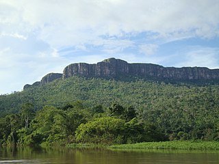
The Guayanan Highlands moist forests (NT0124) is an ecoregion in the south of Venezuela and the north of Brazil and in Guyana, Suriname, French Guiana. It is in the Amazon biome. It encompasses an upland region with diverse fauna and flora, which contains dramatic tepuis, or sandstone table mountains. The region has been inaccessible in the past and is generally fairly intact, apart from the north and northeast where large scale agriculture, ranching and mining operations are steadily encroaching on the ecosystem. New roads are opening the interior to logging, and planned dams will have a drastic impact on the riparian zones.

<span class="mw-page-title-main">Guianan moist forests</span>

The Guianan moist forests (NT0125) is an ecoregion in the east of Venezuela, north of Brazil and the Guyanas. It is in the Amazon biome. The climate is hot and humid, with two rainy seasons each year. As of 1996 the tropical rainforest habitat was relatively intact, although there were mounting threats from illegal logging and gold mining.

<span class="mw-page-title-main">Amazon–Orinoco–Southern Caribbean mangroves</span>

The Amazon–Orinoco–Southern Caribbean mangroves (NT1401) is an ecoregion along the coasts of Colombia, Venezuela, Guyana, Suriname, French Guiana and Brazil.

<span class="mw-page-title-main">Guianan mangroves</span> Coastal ecoregion of southeastern Venezuela, Guyana, Suriname and French Guiana

The Guianan mangroves (NT1411) is a coastal ecoregion of southeastern Venezuela, Guyana, Suriname, French Guiana and Brazil. The mangroves provide an important habitat for migrating birds that winter in the area. Large areas are intact, although they are threatened by destruction of the trees for timber and to make way for agriculture, and from upstream agricultural and industrial pollution.

<span class="mw-page-title-main">Amapá mangroves</span>

The Amapá mangroves (NT1402) is an ecoregion along the Atlantic coast of the state of Amapá in Brazil. The low coastal plain has been formed from recent sedimentation, including sediments deposited by the rivers and sediments carried northward from the mouth of the Amazon River by strong currents and deposited by the tides. The extensive mangroves grow on the newly formed coastal mudflats and along the edges of estuaries. They merge into freshwater várzea flooded forests further inland. The ecoregion is generally well-preserved, although excessive extraction of natural resources including timber and shrimps is a concern.

<span class="mw-page-title-main">Pará mangroves</span>

The Pará mangroves (NT1427) is an ecoregion along the Atlantic coast of the state of Pará in Brazil. They constitute the western extension of the Maranhão mangroves ecoregion. The mangroves are relatively intact, although they are under some pressure from agriculture and logging.

<span class="mw-page-title-main">Paramaribo swamp forests</span>

The Paramaribo swamp forests (NT0149) is an ecoregion in the coastal plain of Suriname covering a strip of land that is almost always flooded by fresh waters. It transitions into saline mangrove swamps towards the coast, and into submontane forests towards the interior.

<span class="mw-page-title-main">Amana Nature Reserve</span>

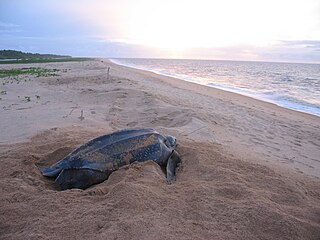
The Amana Nature Reserve is a nature reserve in French Guiana, France. It has been protected, because it is one of the world's largest leatherback turtle nesting site. It is part of the communes of Awala-Yalimapo and Mana.

<span class="mw-page-title-main">Amazonia marine ecoregion</span> Tropical marine ecoregion

The Amazonia marine ecoregion covers the coastal marine environment off the mouth of the Amazon River on the continental shelf of Brazil. The warm North Brazil Current moves east-to-west across the river's outlet, carrying turbid, fresh water to the northwest towards the Caribbean Sea. The Amazonia is one of two ecoregions in the North Brazil Shelf province, a large marine ecosystem (LME). It is thus part of the Tropical Atlantic realm.

<span class="mw-page-title-main">Eastern Brazil marine ecoregion</span> Tropical marine ecoregion

The Eastern Brazil marine ecoregion covers the coastal marine environment along the middle of the east coast of Brazil. The ecoregion extends south from the Bay of All Saints to Cabo Frio just east of the city of Rio de Janeiro. The Brazil Current enters from the east, feeding warm subtropical water to the south along the coast. The influence of the tropical waters leaves the ecoregion relatively oligotrophic. The Eastern Brazil ecoregion is one of two coastal marine ecoregions in the Tropical Southwest Atlantic marine province. It is thus part of the Tropical Atlantic realm. .

<span class="mw-page-title-main">Rio de la Plata marine ecoregion</span> Tropical marine ecoregion

The Rio de la Plata marine ecoregion covers the mouth of the Rio de la Plata, between the shores of Argentina an Uruguay and inshore of the continental shelf of the Uruguay - Buenos Aires Shelf marine ecoregion. The ecoregion is an important reproductive and nursery ground for marine life, as the river runoff provides nutrients for larval and juvenile phases, the shallow and protective waters admit light, and there is of mixing fresh and salt waters. The region is in the Warm Temperate Southwest Atlantic marine province, a part of the Tropical Atlantic realm. .

References

  1. 1 2 3 "Setting Geographic Priorities for Marine Conservation in Latin America and the Caribbean" (PDF). The Nature Conservancy. Retrieved June 30, 2022.
  2. 1 2 3 "The Guiana Current". University of Miami. Retrieved June 30, 2022.
  3. "Guyana-Suriname basin: Rise from obscurity to super potential". WorldOil. Retrieved July 1, 2022.
  4. "World-class Liza field accounts for 15% of all crude found globally since 2015". Oil Now. Retrieved July 1, 2022.
  5. "North Brazil Shelf". One Shared Ocean. Retrieved June 30, 2022.
  6. Spalding, MD; Fox, Helen; Allen, Gerald; Davidson, Nick. "Marine Ecoregions of the World: A Bioregionalization of Coastal and Shelf Areas". Bioscience. Retrieved June 30, 2022.{{cite web}}: CS1 maint: multiple names: authors list (link)
  7. 1 2 3 "Guianan". Digital Observatory for Protected Areas (DOPA). Retrieved June 30, 2022.
  8. "Guianan". MarineRegions.org. Retrieved June 3, 2022.
  9. Wenxiu Yang. "Tectonostratigraphic evolution of the Guyana Basin". AAPG Bulletin. Retrieved July 1, 2022.
  10. "North Brazil Current". University of Miami. Retrieved June 30, 2022.
  11. "The Amazon River Plume". Nature. Retrieved June 30, 2022.
  12. "Guianan Current". Encyclopedia Britannica. Retrieved July 1, 2022.
  13. 1 2 3 "Global Bycatch Assessment of Long-Lived Species - Country Profile: Suriname" (PDF). Project Global. Retrieved July 1, 2022.
  14. "REPORT SOCIO-ECONOMIC STUDY OF THE FISHERIES SECTOR IN SURINAME 28 JUNE 2017" (PDF). World Wildlife Fund Guianas. Retrieved July 1, 2022.
  15. Isaac, Victoria J.; Ferrari, Stephen F. (2017). "Assessment and management of the North Brazil Shelf Large Marine Ecosystem". Environmental Development. 22: 97–110. doi: 10.1016/j.envdev.2016.11.004 . Retrieved July 1, 2022.