
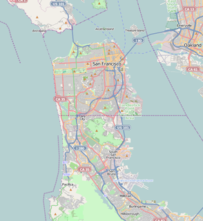
San Francisco Bay is a shallow estuary in the U.S. state of California. It is surrounded by a contiguous region known as the San Francisco Bay Area, and is dominated by the large cities of San Francisco, San Jose, and Oakland.

The Baja California Peninsula is a peninsula in Northwestern Mexico. It separates the Pacific Ocean from the Gulf of California. The peninsula extends 1,247 km from Mexicali, Baja California in the north to Cabo San Lucas, Baja California Sur in the south. It ranges from 40 km at its narrowest to 320 km at its widest point and has approximately 3,000 km of coastline and approximately 65 islands. The total area of the Baja California Peninsula is 143,390 km2 (55,360 sq mi), roughly the same area as the country of Nepal.

Claremont Canyon Regional Preserve is a small regional park mainly located in the city of Oakland, California, and administered by the East Bay Regional Park District. The park is named for the canyon in which it's situated, Claremont Canyon, out of which Claremont Creek flows on its way to its confluence with Temescal Creek. Originally, the canyon was named "Harwood's Canyon", then "Telegraph Canyon". The name was changed to Claremont by a developer of the nearby Claremont district.

Bolinas Lagoon is a tidal estuary, approximately 1,100 acres (4.5 km2) in area, located in the West Marin region of Marin County, California, United States, adjacent to the town of Bolinas. It is a part of the Greater Farallones National Marine Sanctuary and is considered to be among the possible landing spots of Sir Francis Drake on the west coast of North America in 1579.
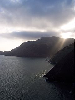
The Marin Headlands is a hilly peninsula at the southernmost end of Marin County, California, United States, located just north of San Francisco across the Golden Gate Bridge, which connects the two counties and peninsulas. The entire area is part of the Golden Gate National Recreation Area. The Headlands are famous for their views of the Bay Area, especially of the Golden Gate Bridge.
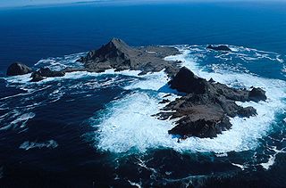
The Farallon Islands, or Farallones, are a group of islands and sea stacks in the Gulf of the Farallones, off the coast of San Francisco, California, United States. The islands are also sometimes referred to by mariners as the Devil's Teeth Islands, in reference to the many treacherous underwater shoals in their vicinity. The islands lie 30 miles (48 km) outside the Golden Gate and 20 miles (32 km) south of Point Reyes, and are visible from the mainland on clear days. The islands are part of the City and County of San Francisco. The only inhabited portion of the islands is on Southeast Farallon Island (SEFI), where researchers from Point Blue Conservation Science and the U.S. Fish and Wildlife Service stay. The islands are closed to the public.

The Greater Farallones National Marine Sanctuary protects the wildlife, habitats, and cultural resources of one of the most diverse and bountiful marine environments in the world, an area of 3,295 square miles off the northern and central California coast. The waters within Greater Farallones National Marine Sanctuary are part of a nationally significant marine ecosystem, and support an abundance of life, including many threatened or endangered species.
Seal Rock is a group of small rock formation islands in the Lands End area of the Outer Richmond District in western San Francisco, California. They are located just offshore in the Pacific Ocean, at the north end of the Ocean Beach, near the Cliff House and Sutro Baths ruins.

The Golden Gate Biosphere is a biosphere reserve in Northern California. It was created by UNESCO in 1988 and encompasses 13 protected areas in the San Francisco Bay Area. It extends through the central California coastal region from the Bodega Marine Reserve in the north to Jasper Ridge in the south and includes the Farallon Islands, Angel Island, and Alcatraz within the San Francisco Bay. The biosphere reserve is situated on both sides of the San Andreas Fault. Each side has a completely different type of bedrock, and the western side of the rift is moving northward. It encompasses a diverse range of marine, coastal, and upland habitats of the California chaparral and woodlands and Northern California coastal forests ecoregions, including mixed evergreen forests, Coast Redwood forests, Douglas-fir forests, Bishop pine forests, oak forests, woodlands and savannas, northern coastal scrub, chaparral, coastal dune, coastal strand, tidepools, kelp forests, coastal grasslands, and marshes. The associated fauna is also rich with cougars, Tule elk, California sea lions, elephant seals, and many shorebirds.
The Castro Rocks are several rocks in Richmond, California protruding from the waters in San Francisco Bay between Castro Point and Red Rock Island.The rocks lie almost directly under the Richmond-San Rafael Bridge (I-580).
The Bonita Channel is a shipping channel which leads northbound traffic out of the Golden Gate to the Gulf of the Farallones and Pacific Ocean.
The Raccoon Strait is a waterway of the San Francisco Bay between Angel Island and the Tiburon Peninsula, mainland Marin County, California. During the ice ages, when sea levels were considerably lower and San Francisco Bay was a grassy valley, the combined Sacramento-San Joaquin river flowed through what is now Raccoon Strait before flowing through the canyon at the Golden Gate.
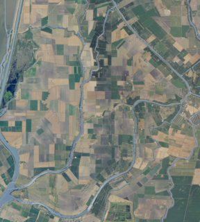
Grand Island is an island lying between Sycamore Slough and the Sacramento River. A post office operated at Grand Island from 1854 to 1919. It is shown, labeled "Taylor Island", on an 1850 survey map of the San Francisco Bay area made by Cadwalader Ringgold and an 1854 map of the area by Henry Lange.
Many ships have wrecked in and around San Francisco Bay. For centuries San Francisco Bay, with its strong currents, rocky reefs, and low fog conditions has experienced more than a hundred shipwrecks. Ever since San Francisco Bay was discovered during the land expedition of Gaspar de Portolà in 1769, it has been one of the most popular harbors.
From 1577 to 1580 Sir Francis Drake circumnavigated the world. In 1579 as part of this voyage he landed on the west coast of North America which consequently has drawn the attention of scores of historians, geographers, linguists, anthropologists and other professionals. In addition, many history buffs have sought to locate Drake's New Albion. The accepted site for Drake's 1579 landing at New Albion is at Drake's Cove in Drakes Bay in Marin County, California. More than a score of ideas have been put forth—covering the coast from Alaska to Baja California Sur, Mexico. These ideas span the eighteenth through the early twenty-first centuries.

The SS City of Chester was a steamship built in 1875 that sank after a collision with RMS Oceanic at the Golden Gate in San Francisco Bay on August 22, 1888.
The United States Naval Radiological Defense Laboratory (NRDL) was an early military lab created to study the effects of radiation and nuclear weapons. The facility was based at the Hunter's Point Naval Shipyard in San Francisco, California.

Joice Island is a small island in Grizzly Bay in the San Francisco Bay Area of California. It is part of Solano County, and partially administered by Reclamation District 2141. It is bordered on the east by Montezuma Slough, on the south by Morrow Island, on the west by Suisun Slough, and on the north by Cutoff Slough. Its coordinates are 38°09′00″N122°03′34″W. An unlabeled island, in the same approximate location as the southernmost part of Joice Island, is shown on an 1850 survey map of the San Francisco Bay area made by Cadwalader Ringgold and an 1854 map of the area by Henry Lange.
