Gweru

Last updated

Gweru
Gwelo
Boggies clock Gweru.jpg
Gweru (coat of arms).png
Motto: 
Progress
Zimbabwe adm location map.svg
Red pog.svg
Gweru
Gweru in Zimbabwe
Coordinates: 19°27′41″S29°48′08″E / 19.46139°S 29.80222°E / -19.46139; 29.80222
Country Zimbabwe
Province Midlands
Founded1894
Incorporated (town)1914
Incorporated (city)1971
Elevation
1,424 m (4,672 ft)
Population
 (2022 census) [1]
  Total158,200
Time zone UTC+2 (CAT)
Climate Cwb
Website https://gwerucitycouncilsite.wordpress.com/

Gweru, originally known as Gwelo, is a city in central Zimbabwe. It is on the centre of Midlands Province. Originally an area known to the Ndebele as "The Steep Place" because of the Gweru River's high banks, in 1894 it became the site of a military outpost established by Leander Starr Jameson. [2] In 1914 it attained municipal status, and in 1971 it became a city.

Contents

The city has a population of 158,200 as of the 2022 census. Gweru is known for farming activities in beef cattle, crop farming, and commercial gardening of crops for the export market. [3] It is also home to a number of colleges and universities, most prominently Midlands State University and Mkoba Teachers College.

The city was nicknamed City of Progress.

History

Gweru used to be named Gwelo. Matabele settlement was named iKwelo ("The Steep Place"), after the river's high banks. The modern town, founded in 1894 as a military outpost, developed as an agricultural centre and became a municipality in 1914.

Geography

The geographical coordinates for Gweru Urban are 19° 27' 0'' South and 29° 49' 0'' East. This places Gweru at the centre of Zimbabwe. The area coverage is almost 46 166 km2. The city is built alongside Bulawayo-Harare railway and the road near the railway spur to Mabuto.

Climate

Climate data for Gweru (1961–1990)
MonthJanFebMarAprMayJunJulAugSepOctNovDecYear
Mean daily maximum °C (°F)26.3
(79.3)
25.8
(78.4)
25.8
(78.4)
24.7
(76.5)
22.9
(73.2)
20.6
(69.1)
20.5
(68.9)
23.3
(73.9)
26.8
(80.2)
28.3
(82.9)
27.4
(81.3)
26.3
(79.3)
24.9
(76.8)
Mean daily minimum °C (°F)15.3
(59.5)
15.1
(59.2)
13.8
(56.8)
11.3
(52.3)
7.6
(45.7)
4.9
(40.8)
4.5
(40.1)
6.5
(43.7)
10.0
(50.0)
13.1
(55.6)
14.5
(58.1)
15.1
(59.2)
11.0
(51.8)
Average rainfall mm (inches)139.1
(5.48)
124.8
(4.91)
55.9
(2.20)
29.0
(1.14)
7.7
(0.30)
1.9
(0.07)
1.0
(0.04)
1.9
(0.07)
9.3
(0.37)
35.1
(1.38)
96.2
(3.79)
159.4
(6.28)
661.3
(26.04)
Average rainy days12107311001491260
Source: World Meteorological Organization [4]

Demographics

Nature and wildlife

In and around Gweru there are attractive places, some are man-made and some are natural. There is:

Historical population
YearPop.±%
19362,165    
19415,100+135.6%
19467,237+41.9%
19519,800+35.4%
196027,290+178.5%
196936,840+35.0%
197451,000+38.4%
197866,000+29.4%
198278,918+19.6%
1992128,037+62.2%
2002141,260+10.3%
2012157,865+11.8%

Economy

Situated along the road and railway between Harare and Bulawayo and near the rail spur to Maputo, Mozambique, Gweru has become a busy trade centre with modest industrial development. Its products include ferrochromium, textiles, dairy foods, leather, and building materials. The surrounding area, with its rich deposits of gold, chrome, iron, asbestos, and limestone, supports a number of mines. The training section of Zimbabwe's air force is in Gweru at the Gweru-Thornhill Air Base.

The city is also known for vibrant farming activities in cattle ranching, and farming including, commercial gardening of crops for the export market. The country's oldest shoe manufacturer, the Bata Shoe Company and the Military and Aviation Museums are also some key features for which Gweru is well known. [3]

Culture

The Boggie clock tower, located at the intersection of Main Street and Robert Mugabe Way, was built in 1928 in memory of Major William James Boggie. The clock tower is one of the city's most famous landmarks. [2]

The Nalatale and Danamombe archaeological sites lie approximately 70 and 85 km to the southwest, the known for their patterned stonework. The remains at these sites date back to as early as the Torwa state during the 17th century, the most substantial being a four hundred-year-old stone wall decorated with motifs known to the tradition of stone-building in Zimbabwe. The surrounding area has rich deposits of gold, chrome, iron, asbestos and platinum and supports several mines. [2]

Tourism

The main hotel in the city is the Midlands Hotel, which was opened in 1927 by the Meikles brothers. This hotel was to be demolished but after many protests by the population it was saved. Another important hotel is the Chitukuko (formerly the Hotel Cecil), located in the downtown area of the city. Both hotels were owned by Patrick Kombayi, a former mayor. The Fairmile Motel is just one mile from the city center on the Bulawayo highway .

Sports and stadia

Soccer

  • Chapungu Football Club

Chapungu F.C team was nicknamed Waru Waru and the team is currently playing in Zimbabwe Premier League Soccer League. Its home is Ascot Stadium.

There is also Gweru Sports club which has playgrounds for rugby, bowling and cricket.

Government and politics

Education

Primary education

Group A

Group B

Secondary education

Group A

Group B

Tertiary education

Defunct colleges and universities

  • Midlands College of Commerce (closed 1994)

Media

Gweru's local newspaper, The Gweru Times, once ceased publishing in 2015 but now operational.

Industry

In Gweru there are big companies that are still operating and are still capable of employing hundreds of employees. Not forgetting future big companies which are SMEs are also listed. These companies are in and around Gweru. Below are the list of companies grouped according to size and type of the industry. Some of the companies in Gweru are Bata Shoe Company, ZimGlass, ZimCast, ZimAlloys, Delta Corporation, Anchor Yeast, and Midlands State University.

Transportation

Railway

Railways arrived in Gwelo (Gweru) in 1902. National Railways of Zimbabwe have the country's largest marshalling yard, Dabuka, on the south side of Gweru. Dabuka plays a pivotal role in rail movement in the country as it is the central hub of the rail links to Mozambique in the east, South Africa in the south and Botswana and Namibia in the south west, lying on the Beira–Bulawayo railway. [5]

Gwelo was once home to the Gwelo & District Light Railway, a 2 ft gauge steam for pleasure railway.

Roads

As a central city (hub), it has direct links to all the other cities and towns of Zimbabwe. It is 164 km from Bulawayo, 183 km from Masvingo, 471 km from Beitbridge, and 275 km from Harare.

Road names used are by destination only, for example the Harare-Bulawayo Road. There are only mainroads, no highways or freeways. [6]

Notable people

Sister cities

See also

Related Research Articles

<span class="mw-page-title-main">Bulawayo</span> City and province in Zimbabwe

Bulawayo is the second largest city in Zimbabwe, and the largest city in the country's Matabeleland region. The city's population is disputed; the 2022 census listed it at 665,940, while the Bulawayo City Council claimed it to be about 1.2 million. Bulawayo covers an area of 546 square kilometres in the western part of the country, along the Matsheumhlope River. Along with the capital Harare, Bulawayo is one of two cities in Zimbabwe that are also provinces.

<span class="mw-page-title-main">Mutare</span> Largest and Admistration City of Manicaland Province, Zimbabwe

Mutare, formerly known as Umtali until 1982, is the most populous city in the province of Manicaland, and the third most populous in Zimbabwe, having surpassed Gweru in the 2012 census, with an urban population of 224,802 and approximately 260,567 in the surrounding districts, giving the wider metropolitan area a total population of over 500,000 people. Mutare is also the capital of Manicaland Province and the largest city in eastern Zimbabwe.

<span class="mw-page-title-main">Zvishavane</span> Town in Midlands, Zimbabwe

Zvishavane, formerly known as Shabani, is a mining town in Midlands Province, Zimbabwe. Surrounded by low hills, it lies 97 kilometres (60 mi) west of Masvingo, on the main Bulawayo-Masvingo road. Other roads lead from Zvishavane to Gweru, 121 kilometres (75 mi) north, and Mberengwa, 27 kilometres (17 mi) south-west. It is also on direct rail links to Gweru and Beit Bridge which then link up with Harare and Bulawayo in Zimbabwe and to Maputo in Mozambique, and Pretoria in South Africa. It has a private airport serving the city.

<span class="mw-page-title-main">Victoria Falls, Zimbabwe</span> Resort City in Matabeleland North, Zimbabwe

Victoria Falls, popularly known as Vic Falls, is a resort town and city in the province of Matabeleland North, Zimbabwe. It lies on the southern bank of the Zambezi River at the western end of Victoria Falls themselves. According to the 2022 Population Census, the town had a population of 35,199.

<span class="mw-page-title-main">National Railways of Zimbabwe</span> State-owned railway in Zimbabwe

The National Railways of Zimbabwe (NRZ), formerly Rhodesia Railways (RR), is a Bulawayo headquartered state-owned enterprise that operates the country's national railway system. It was established in 1893 and is governed by an Act of Parliament. It has a commercial-administrative center in Harare and a supply center in Gweru. The Zimbabwean railway system was largely constructed during the 20th century.

Shurugwi, originally known as Selukwe, is a small town and administrative centre in Midlands Province, southern Zimbabwe, located about 350 km south of Harare, with a population of 22,900 according to the 2022 census. The town was established in 1899 on the Selukwe Goldfield, which itself was discovered in the early 1890s not long after the annexation of Rhodesia by the Pioneer Column.

<span class="mw-page-title-main">Beitbridge</span> Town in Matabeleland South, Zimbabwe

Beitbridge is a border town in the province of Matabeleland South, Zimbabwe. The name also refers to the border post and bridge spanning the Limpopo River, which forms the political border between South Africa and Zimbabwe. The border on the South African side of the river is also named Beitbridge.

<span class="mw-page-title-main">Zimbabwe Stock Exchange</span> Stock exchange in Harare, Zimbabwe

The Zimbabwe Stock Exchange, or ZSE, is the official stock exchange of Zimbabwe. Its history dates back to 1896 but has only been open to foreign investment since 1993. The exchange has about a dozen members, and currently lists 63 equities. There are two primary indices, the ZSE All Share and the ZSE Top 10.

<span class="mw-page-title-main">Kwekwe</span> City in Midlands, Zimbabwe

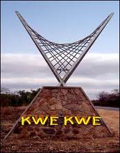
Kwekwe, formerly known as Que Que, is a city in the Midlands province in central Zimbabwe. The city has a population of 119,863 within the city limits, as of the 2022 census, making it the 7th-largest city in Zimbabwe and the second-most populous city in the Midlands, behind Gweru.

Articles related to Zimbabwe include:

Lovemore Tshuma, commonly known as Lovemore Majaivana is a Zimbabwean musician, arguably the most popular Ndebele singer, and by far the most prominent to have come out of Gweru. He earned the stage name 'Majaivana' for his exceptional dancing.

Lower Gwelo is a developed communal settlement in the Midlands province, Zimbabwe and is located about 40km north-west of Gweru, and stretches a further 50 km to the west. Lower gwelo was initially called Somabhula and later became Somabhula ekhanyayo after the establishment of Seventh day adventist missions stations that covered the entire area. The 2 main Chiefs in the Lower Gwelo area are Chief Sogwala and Chief Bunina. There are 5 Headmen under Chief Sogwala:

<span class="mw-page-title-main">Ikwelo River</span> River in central Zimbabwe

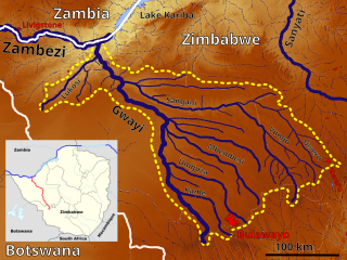
Gweru River is a river in Midlands Province of Zimbabwe.

Chirumanzu–Zibagwe is a constituency of the National Assembly of the Parliament of Zimbabwe, located in the Chirumhanzu District in Midlands Province. Mvuma, a small mining town, is one of the largest commercial centers in the constituency. The constituency was created in 2008 from the old Chirumanzu and Zhombe constituencies. Emmerson Mnangagwa, now the President of Zimbabwe, was the inaugural member, followed by his wife, Auxillia Mnangagwa. Its current Member of Parliament is Prosper Machando (ZANU–PF).

<span class="mw-page-title-main">Gweru District</span> District in Midlands, Zimbabwe

Gweru District is a district in the [[Midlands it is the center of Zimbabwe. .(Zimbabwe)|Midlands]] Province of Zimbabwe.

<span class="mw-page-title-main">Chirumhanzu District</span> Administrative district in Midlands, Zimbabwe

Chirumhanzu District is a Second-order Administrative Sub-division of Midlands (Zimbabwe) between Gweru and Masvingo.

Prag Lalloo Naran was a Zimbabwean politician and businessman recognized as a "Nationalist for the struggle for Zimbabwe’s independence," and a "leading member of the (Zimbabwe) Asian Community".

<span class="mw-page-title-main">Beira–Bulawayo railway</span> Railway line in southern Africa

Beira-Bulawayo railway, also called Machipanda railway, Beira-Harare-Bulawayo railway and Beira railway, is a railway that connects the city of Beira, Mozambique, to the city of Bulawayo, in Zimbabwe. It is 850 km long, in a 1067 mm gauge.

References

  1. Citypopulation.de Population of the major cities in Zimbabwe
  2. 1 2 3 "Gweru – The City of Progress". mygweru.com. Retrieved 14 November 2016.
  3. 1 2 "Gweru | Zimbabwe". Encyclopædia Britannica. Retrieved 14 November 2016.
  4. "World Weather Information Service – Gweru". World Meteorological Organization. Retrieved 25 October 2015.
  5. Mlambo, Alois (2003). "Bulawayo, Zimbabwe". In Paul Tiyambe Zeleza; Dickson Eyoh (eds.). Encyclopedia of Twentieth-Century African History. Routledge. ISBN   0415234794.
  6. The Automobile Association of Zimbabwe
  7. "Local Government International Bureau (LGIB) Database of "Twinning Towns". Archived from the original on 27 April 2007. Retrieved 16 April 2007.