
Addington is an area in the London Borough of Croydon located 11.1 miles (18 km) south of Charing Cross. It lies within the historic county of Surrey.

Hadlow is a village in the borough of Tonbridge and Malling in Kent, England. It is situated in the Medway valley, north-east of Tonbridge and south-west of Maidstone.

Sturry is a village on the Great Stour river three miles northeast of Canterbury in Kent. Its large civil parish incorporates several hamlets and, until April 2019, the former 'mining village' of Hersden.

Whirlow is a suburb of the City of Sheffield in England, it lies 3.7 miles (6 km) south-west of the city centre. The suburb falls within the Dore and Totley ward of the City. It is one of the most affluent areas of Sheffield, with much high class housing and several notable small country houses within it. During the Victorian era it was home to some of Sheffield's most influential citizens. Whirlow straddles the A625, the main Sheffield to Hathersage road. The suburb covers the area from Parkhead in the north to Whirlow Bridge in the south and from Ecclesall Woods in the east to Broad Elms Lane in the west. Whirlow had a population of 1,663 in 2011.
Albany Park is an area of South East London, England, within the London Borough of Bexley. It is located 12.0 miles (19 km) south east of Charing Cross. It lies within the Historic County of Kent. Located midway between Sidcup and Bexley, Albany Park is situated on high ground overlooking the valleys of the River Cray and the River Shuttle.

Chartham is a village and civil parish in the Canterbury district of Kent, England. It is situated on the Ashford side of the city, and is in the North Downs area of Outstanding Natural Beauty, 2.3 miles (4 km) south west of Canterbury, England. The Great Stour Way path passes through the village. A paper mill in the village has specialised in the production of tracing paper since 1938. There are numerous arable farms and orchards in the parish. The village has an unmanned station, Chartham, and a manned level crossing. It has an outlying locality sharing in many of the community resources, Chartham Hatch.

Rolvenden is a village and civil parish in the Ashford District of Kent, England. The village is centred on the A28 Ashford to Hastings road, 5 miles (8.0 km) south-west of Tenterden.

Ospringe is a village and area of Faversham in the English county of Kent. It is also the name of a civil parish, which since 1935 has not included the village of Ospringe.

Hackington is a semi-rural village and civil parish immediately north of Canterbury in Kent, England, the main community of which is Tyler Hill. In earlier periods it was sometimes known as St Stephen's.

Tunstall is a village in the Borough of Swale in Kent, England. Situated to the south of Sittingbourne, on the road towards Bredgar.

Newbold Comyn is a park on the Eastern edge of Leamington Spa, Warwickshire, England.
Sir Christopher Hales was an English judge and Master of the Rolls.

Ingress Abbey was a Neo-gothic Jacobean-style country house in the hamlet of Greenhithe, Kent, England. It was built on the Ingress Estate, owned by the Viscount Duncannon in the 18th century and after having been passed on among many owners the buildings were demolished in 1820. The current buildings were built in 1833 in Elizabethan style.
Sir Edward Hales, 3rd Baronet was an English politician who sat in the House of Commons of England from 1679 to 1681. He became a Catholic and supported King James II at the time of the Glorious Revolution.

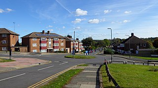
Eddington was a village in Kent, South East England to the south-east of Herne Bay, to the west of Beltinge and to the north of Herne. It is now a suburb of Herne Bay, in Greenhill and Eddington Ward, one of the five wards of Herne Bay. Its main landmark for over 100 years until 2010 was Herne Bay Court, a former school which once possessed one of the largest and best-equipped school engineering workshops in England; it later became a Christian conference centre.

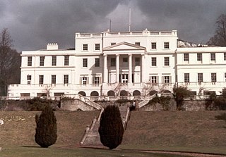
Burton Pynsent House is a historic country-house in the parish of Curry Rivel, Somerset, England. It is a Grade II* listed building. The house was built in stages between 1565 and 1765, when it was bequeathed to William Pitt, 1st Earl of Chatham by Sir William Pynsent, 2nd Baronet, who did not want the house to go to Lord North. Pitt had an additional wing built to a design by Lancelot Brown, and the subsequent owner demolished everything but this wing in 1805.

The College of All Saints was an ecclesiastical college in Maidstone, Kent, England, founded in 1395 by Archbishop Courtenay. It was part of the establishment of the nearby Archbishop's Palace, but was closed in 1546. The College church was the neighbouring Church of All Saints. Following its closure, the College estate was sold. The buildings and land passed through the ownership of three aristocratic families, being farmed until the late 19th century. A number of the College's buildings survive and all are listed buildings. Additionally, the whole site of the College is protected as a scheduled monument.
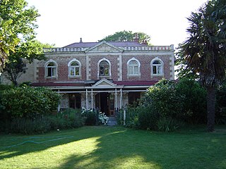
Linwood House was built as the homestead for Joseph Brittan, who as surgeon, newspaper editor, and provincial councillor, was one of the dominant figures in early Christchurch, New Zealand. The suburb of Linwood was named after Brittan's farm and homestead. Brittan's daughter Mary married William Rolleston, and they lived at Linwood House following Joseph Brittan's death. During that time, Rolleston was the 4th Superintendent of the Canterbury Province, and Linwood House served for many important political and public functions.
Linton Park, formerly Linton Place or Linton Hall, is a large 18th-century country house in Linton, Kent, England. Built by Robert Mann in 1730 to replace an earlier building, the house and estate passed through the ownership of several members of Mann's family before coming into the Cornwallis family. The house was enlarged to its current size in 1825.

Holland House, Kingsgate, in Kent, is a Georgian country house built between 1762 and 1768 as his retirement home by the politician Henry Fox, 1st Baron Holland (1705-1774), of Holland House in Kensington. It is a Grade II listed building.

