
The Province of Upper Canada was a part of British Canada established in 1791 by the Kingdom of Great Britain, to govern the central third of the lands in British North America, formerly part of the Province of Quebec since 1763. Upper Canada included all of modern-day Southern Ontario and all those areas of Northern Ontario in the Pays d'en Haut which had formed part of New France, essentially the watersheds of the Ottawa River or Lakes Huron and Superior, excluding any lands within the watershed of Hudson Bay. The "upper" prefix in the name reflects its geographic position along the Great Lakes, mostly above the headwaters of the Saint Lawrence River, contrasted with Lower Canada to the northeast.

The Trans-Canada Highway is a transcontinental federal–provincial highway system that travels through all ten provinces of Canada, from the Pacific Ocean on the west coast to the Atlantic Ocean on the east coast. The main route spans 7,476 km (4,645 mi) across the country, one of the longest routes of its type in the world. The highway system is recognizable by its distinctive white-on-green maple leaf route markers, although there are small variations in the markers in some provinces.

United Empire Loyalists is an honorific title which was first given by the 1st Lord Dorchester, the Governor of Quebec, and Governor General of the Canadas, to American Loyalists who resettled in British North America during or after the American Revolution. At the time, the demonym Canadian or Canadien was used to refer to the indigenous First Nations groups and the descendants of New France settlers inhabiting the Province of Quebec.

Guy Carleton, 1st Baron Dorchester, known between 1776 and 1786 as Sir Guy Carleton, was a British Army officer, peer and colonial administrator. He twice served as Governor of the Province of Quebec, from 1768 to 1778, concurrently serving as Governor General of British North America in that time, and again from 1785 to 1795. The title Baron Dorchester was created on 21 August 1786.

Canada has a large domestic and foreign tourism industry. The second largest country in the world, Canada's incredible geographical variety is a significant tourist attractor. Much of the country's tourism is centred in the following regions: Toronto, Montreal, Quebec City, Vancouver/Whistler, Niagara Falls, Vancouver Island, Canadian Rockies, British Columbia's Okanagan Valley, Churchill, Manitoba and the National Capital Region of Ottawa-Gatineau. The large cities are known for their culture, diversity, as well as the many national parks and historic sites.
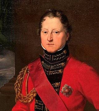
General Sir Gordon Drummond, GCB was a Canadian-born British Army officer and the first official to command the military and the civil government of Canada. As Lieutenant Governor of Upper Canada, Drummond distinguished himself on the Niagara front in the War of 1812 and later became Governor-General and Administrator of Canada.

The Intercolonial Railway of Canada, also referred to as the Intercolonial Railway (ICR), was a historic Canadian railway that operated from 1872 to 1918, when it became part of Canadian National Railways. As the railway was also completely owned and controlled by the Government of Canada, the Intercolonial was also one of Canada's first Crown corporations.

The Grand Trunk Railway was a railway system that operated in the Canadian provinces of Quebec and Ontario and in the American states of Connecticut, Maine, Michigan, Massachusetts, New Hampshire, and Vermont. The railway was operated from headquarters in Montreal, Quebec, with corporate headquarters in London, United Kingdom. It cost an estimated $160 million to build. The Grand Trunk, its subsidiaries, and the Canadian Government Railways were precursors of today's Canadian National Railway.

Ontario came into being as a province of Canada in 1867 but historians use the term to cover its entire history. This article also covers the history of the territory Ontario now occupies.

Eastern Ontario is a secondary region of Southern Ontario in the Canadian province of Ontario which lies in a wedge-shaped area between the Ottawa River and St. Lawrence River. It shares water boundaries with Quebec to the north and New York State to the east and south, as well as a small land boundary with the Vaudreuil-Soulanges region of Quebec to the east.
The National Transcontinental Railway (NTR) was a historic railway between Winnipeg and Moncton in Canada. Much of the line is now operated by the Canadian National Railway.

King's Highway 2, commonly referred to as Highway 2, is the lowest-numbered provincially maintained highway in the Canadian province of Ontario, and was originally part of a series of identically numbered highways which started in Windsor, stretched through Quebec and New Brunswick, and ended in Halifax, Nova Scotia. Prior to the 1990s, Highway 2 travelled through many of the major cities in Southern Ontario, including Windsor, Chatham, London, Brantford, Hamilton, Burlington, Mississauga, Toronto, Oshawa, Belleville, Kingston and Cornwall, amongst many other smaller towns and communities.

Wolfe Island is an island at the entrance to the Saint Lawrence River in Lake Ontario near Kingston, Ontario. Wolfe Island is part of Frontenac County, Ontario and the Township of Frontenac Islands. It is the largest of the Thousand Islands. The largest community on the island is Marysville.

The Quebec City–Windsor Corridor is the most densely populated and heavily industrialized region of Canada. As its name suggests, the region extends between Quebec City in the northeast and Windsor, Ontario, in the southwest, spanning 1,150 kilometres (710 mi). With more than 18 million people, it contains about half of the country's population, three of Canada's four largest metropolitan areas and seven of Canada's twelve largest metropolitan areas, all based on the 2016 census. Its relative importance to Canada's economic and political infrastructure renders it akin to the Northeast megalopolis in the United States. The name was first popularized by Via Rail, which runs frequent passenger rail service in the region in its service area known as "The Corridor".

Canterbury is a former village in York County, in the Canadian province of New Brunswick. It held village status prior to 2023 and is now part of the village of Lakeland Ridges. The community is west of the Trans-Canada Highway at the intersection of Route 122 and Route 630.

Fort Gaspareaux was a French fort at the head of Baie Verte near the mouth of the Gaspareaux River and just southeast of the modern community of Strait Shores, New Brunswick, Canada, on the Isthmus of Chignecto. It was built during Father Le Loutre's War and is now a National Historic Site of Canada overlooking the Northumberland Strait.
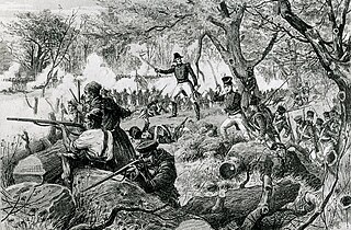
When the United States and the United Kingdom went to war against each other in 1812, the major land theatres of war were Upper Canada, Michigan Territory, Lower Canada and the Maritime Provinces of Nova Scotia, New Brunswick, Prince Edward Island and Cape Breton . Each of the separate British administrations formed regular and fencible units, and both full-time and part-time militia units, many of which played a major part in the fighting over the two and a half years of the war.
The technological and industrial history of Canada encompasses the country's development in the areas of transportation, communication, energy, materials, public works, public services, domestic/consumer and defense technologies. Most technologies diffused in Canada came from other places; only a small number actually originated in Canada. For more about those with a Canadian origin, see Invention in Canada.
104th Regiment of Foot was a regiment of the British Army. The regiment had its origins in the New Brunswick Regiment of Fencible Infantry, a unit of fencibles raised for the defence of the colony of New Brunswick in 1803. Recruits were drawn from across British North America, Scotland, Ireland and existing British Army units. The regiment was formally entered into the establishment in 1806 with a strength of around 650 enlisted men but grew to almost 1,100 by 1808. In 1810 the regiment's officers requested that it join the British Army as a regiment of foot. This request was granted on 13 September 1810 and the unit was renamed the 104th Regiment of Foot.

Section 68 of the Constitution Act, 1867 is a provision of the Constitution of Canada relating to the seats of government of the four original provinces, New Brunswick, Nova Scotia, Ontario and Quebec.