Hanover Township, Luzerne County, Pennsylvania

Last updated

Hanover Township,
Luzerne County,
Pennsylvania
Industry and Agriculture.jpg
Huber Breaker in Ashley Borough, as viewed from a farm in Hanover Township
Motto: 
"A progressive growing community"
Map of Luzerne County, Pennsylvania Highlighting Hanover Township.PNG
Map of Luzerne County highlighting Hanover Township
Map of Pennsylvania highlighting Luzerne County.svg
Map of Pennsylvania highlighting Luzerne County
Country United States
State Pennsylvania
County Luzerne
Settled1772
Incorporated1790
Area
[1]
  Total19.21 sq mi (49.77 km2)
  Land18.87 sq mi (48.86 km2)
  Water0.35 sq mi (0.90 km2)
Population
 (2020) [2]
  Total11,424 Increase2.svg
  Estimate 
(2021) [2]
11,418
  Density575.64/sq mi (222.25/km2)
Time zone UTC-5 (Eastern (EST))
  Summer (DST) UTC-4 (EDT)
ZIP codes
18634, mostly 18706
Area code(s) 570 & 272
FIPS code 42-079-32416
Website hanovertownship.org

Hanover Township is a township in Luzerne County, Pennsylvania. As of the 2020 census, [2] the population was 11,424, making it the most populous township in the county.

Contents

History

A 19th century map of Hanover Township MapHanoverTwp,LuzerneCounty.jpg
A 19th century map of Hanover Township

Hanover Township was one of the original townships laid out by the Susquehanna Company of Connecticut. Captain Lazarus Stewart and dozens of his followers moved from Lancaster County into the Wyoming Valley in 1770; they fought for Connecticut in the Yankee-Pennamite Wars. For their service to Connecticut, Captain Stewart and his followers were granted a tract of land which became Hanover Township. The community was named after Lazarus Stewart's hometown of Hanover in Dauphin County, Pennsylvania. In the early 1770s, Captain Lazarus Stewart built the first house in the Breslau section of the township (between Solomon Creek and the Susquehanna River). [3]

Native American raids were very common in the Wyoming Valley in the 18th century. On July 3, 1778, Loyalist and Iroquois forces routed the Patriot militia at the Battle of Wyoming in present-day Exeter. Over two dozen Hanover Township residents were killed in the fight. [3]

The original township occupied all the land from Wilkes-Barre to Newport Township, and all the land between the Susquehanna River and the Lehigh River. In the 19th century, the original township downsized when sections of it broke away to form new municipalities, including townships, boroughs, and cities.

In the following decades, coal mining became the major industry in and around Hanover Township. Coal breakers were constructed throughout the region. One, in particular, was built in modern-day Ashley; it was known as the Huber Breaker.

Following the collapse of the mining industry in Wyoming Valley, the breaker was demolished in 2014. Ashley Planes, a historic freight cable railroad in Hanover and Fairview Townships, was listed on the National Register of Historic Places in 1980. [4]

Geography

A satellite map of Solomon Creek flowing through Hanover Township. Solomon Creek satellite map.PNG
A satellite map of Solomon Creek flowing through Hanover Township.
Hanover Township (in foreground) borders Nanticoke City (middle); the South Cross Valley Expressway (PA 29) crosses over the Susquehanna River and links Hanover Township to Plymouth Township (on right). Nanticoke City.jpg
Hanover Township (in foreground) borders Nanticoke City (middle); the South Cross Valley Expressway (PA 29) crosses over the Susquehanna River and links Hanover Township to Plymouth Township (on right).
Hanover Area School District in Luzerne County Map of Luzerne County Pennsylvania School Districts.png
Hanover Area School District in Luzerne County

According to the United States Census Bureau, the township has a total area of 19.2 square miles (49.8 km2), of which 18.9 square miles (48.9 km2) is land and 0.35 square miles (0.9 km2), or 1.82%, is water. The Susquehanna River drains the municipality and separates it from Larksville Borough, Plymouth Borough, and Plymouth Township. The north side of the township — near the river — is mainly low-lying (500 to 650 ft or 150 to 200 m above sea level); most of the township's homes and businesses reside in the northern and central portions of the township. The southern portion of the municipality is mountainous, rising to 2,148 feet (655 m) at the summit of Haystack Mountain on the southeast border. The township lies directly between the cities of Wilkes-Barre and Nanticoke.

The main thoroughfares in Hanover Township are the South Cross Valley Expressway (PA 29), the four-lane Sans Souci Parkway (locally pronounced "San Suey"), and the two-lane South Main Street. The former connects I-81 in the southeast with U.S. 11 in West Nanticoke which connects Wilkes-Barre and Nanticoke.

I-81 and PA 309 provide access to Hazleton, Wilkes-Barre Township, and Scranton. In the northern portion of the community, the Carey Ave Bridge, also known as the 1st Battalion, 109th Field Artillery Pennsylvania Army National Guard Bridge. crosses the Susquehanna River, linking Hanover Township to Plymouth and Larksville. [5]

Hanover's 12 villages are Askam, Breslau, Buttonwood, Dundee, Hanover Green, Iona, Korn Krest, Lee Park, Lower Askam, Lyndwood, Newtown, and Preston. The township is part of Hanover Area School District, which is located in central Luzerne County.

Neighboring municipalities

Three boroughs, Ashley, Sugar Notch, and Warrior Run, are surrounded by Hanover Township.

Climate

The township has a humid continental climate (Dfa/Dfb) and the hardiness zone is 6a except in Dundee, where it is 6b. Average monthly temperatures in Askam range from 26.3 °F in January to 71.8 °F in July.

Government

Hanover Township is governed by a board of seven commissioners. The following is a list of current board members: [6]

Demographics

Historical population
CensusPop.Note
1970 12,102
1980 12,6014.1%
1990 12,050−4.4%
2000 11,488−4.7%
2010 11,076−3.6%
2020 11,4243.1%
2021 (est.)11,418 [2] −0.1%
[7]

As of the census [8] of 2000, there were 11,488 people, 4,951 households, and 3,153 families residing in the township. The population density was 610.5 inhabitants per square mile (235.7/km2). There were 5,338 housing units at an average density of 283.7 per square mile (109.5/km2). The racial makeup of the township was 98.08% White, 0.96% African American, 0.02% Native American, 0.17% Asian, 0.12% from other races, and 0.64% from two or more races. Hispanic or Latino of any race were 0.60% of the population.

There were 4,951 households, out of which 27.2% had children under the age of 18 living with them, 44.6% were married couples living together, 14.6% had a female householder with no husband present, and 36.3% were non-families. 32.4% of all households were made up of individuals, and 17.4% had someone living alone who was 65 years of age or older. The average household size was 2.29, and the average family size was 2.90.

In the township the population was spread out, with 22.0% under the age of 18, 7.9% from 18 to 24, 26.5% from 25 to 44, 23.0% from 45 to 64, and 20.7% who were 65 years of age or older. The median age was 40 years. For every 100 females, there were 86.2 males. For every 100 females age 18 and over, there were 82.1 males.

The median income for a household in the township was $30,043, and the median income for a family was $37,883. Males had a median income of $29,679, versus $21,691 for females. The per capita income for the township was $16,181. About 12.2% of families and 15.3% of the population were below the poverty line, including 23.0% of those under age 18 and 13.9% of those age 65 or over.

Transportation

Hanover Township is served by the Luzerne County Transportation Authority. The bus routes include:

Related Research Articles

<span class="mw-page-title-main">Wilkes-Barre, Pennsylvania</span> City in Pennsylvania, United States

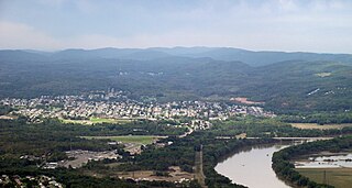
Wilkes-Barre is a city in and the county seat of Luzerne County, Pennsylvania, United States. Located at the center of the Wyoming Valley in Northeastern Pennsylvania, it had a population of 44,328 in the 2020 census. It is the second-largest city, after Scranton, in the Scranton–Wilkes-Barre–Hazleton, PA Metropolitan Statistical Area, which had a population of 567,559 as of the 2020 census, making it the fifth-largest metropolitan area in Pennsylvania after the Delaware Valley, Greater Pittsburgh, the Lehigh Valley, and Greater Harrisburg.

<span class="mw-page-title-main">Luzerne County, Pennsylvania</span> County in Pennsylvania, United States

Luzerne County is a county in the Commonwealth of Pennsylvania. According to the United States Census Bureau, the county has a total area of 906 square miles (2,350 km2), of which 890 square miles (2,300 km2) is land and 16 square miles (41 km2) is water. It is Northeastern Pennsylvania's second-largest county by total area. As of the 2020 census, the population was 325,594, making it the most populous county in the northeastern part of the state. The county seat and most populous city is Wilkes-Barre. Other populous communities include Hazleton, Kingston, Nanticoke, and Pittston. Luzerne County is included in the Scranton–Wilkes-Barre–Hazleton Metropolitan Statistical Area, which has a total population of 555,426 as of 2017. The county is part of the Northeastern Pennsylvania region of the state.

<span class="mw-page-title-main">Bear Creek Township, Pennsylvania</span> Township in Pennsylvania, United States

Bear Creek Township is a township in Luzerne County, Pennsylvania, United States. The township has a total area of 67.8 square miles (176 km2), making it is the largest municipality in Luzerne County. The population was 2,752 at the 2020 census.

<span class="mw-page-title-main">Exeter, Pennsylvania</span> Borough in Pennsylvania, United States

Exeter is a borough in the Greater Pittston-Wilkes-Barre area of Luzerne County, Pennsylvania, United States, about 10 miles (16 km) west of Scranton and a few miles north of Wilkes-Barre. It is located on the western bank of the Susquehanna River and has a total area of 5.0 square miles (12.9 km2). As of 2020, Exeter had a population of 5,513.

<span class="mw-page-title-main">Forty Fort, Pennsylvania</span> Borough in Pennsylvania, United States

Forty Fort is a borough in Luzerne County, Pennsylvania, United States. The population was 4,233 at the 2020 census. Its neighbors are Wyoming, Plains Township, Kingston, and Swoyersville. The Wilkes-Barre Wyoming Valley Airport and the Wyoming Seminary Lower School are both located in the borough.

<span class="mw-page-title-main">Kingston, Pennsylvania</span> Borough in Pennsylvania, United States

Kingston is a borough in Luzerne County, Pennsylvania, United States. It is located on the western bank of the Susquehanna River opposite Wilkes-Barre. Kingston was first settled in the early 1770s, and incorporated as a borough in 1857. As of the 2020 census, the population was 13,349, making it the most populous borough in Luzerne County.

<span class="mw-page-title-main">Kingston Township, Pennsylvania</span> Township in Pennsylvania, United States

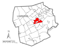
Kingston Township is a township in Luzerne County, Pennsylvania, United States. The population was 7,096 at the 2020 census. The villages of Trucksville and Shavertown are located within the township. It is home to Frances Slocum State Park. The township is described as "the gateway to the Back Mountain". The area includes the townships of Dallas, Franklin, Jackson, Kingston, Lake, and Lehman. The region also includes the boroughs of Dallas and Harveys Lake.

<span class="mw-page-title-main">Larksville, Pennsylvania</span> Borough in Pennsylvania, United States

Larksville is a borough in Luzerne County, Pennsylvania, United States. It is 2 miles (3 km) west of Wilkes Barre on the Susquehanna River. The population was 4,216 as of the 2020 census.

<span class="mw-page-title-main">Mountain Top, Pennsylvania</span> Census-designated place in Pennsylvania, United States

Mountain Top is an unincorporated area and census-designated place (CDP) in Luzerne County, Pennsylvania, United States. As of the 2010 census, its population was 10,982.

<span class="mw-page-title-main">Nanticoke, Pennsylvania</span> City in Luzerne County, Pennsylvania, United States

Nanticoke is a city in Luzerne County, Pennsylvania, United States. As of the 2020 census, the population was 10,628, making it the third largest city in Luzerne County. It occupies 3.6 square miles (9.3 km2) of land. Nanticoke is part of Northeastern Pennsylvania.

<span class="mw-page-title-main">Newport Township, Pennsylvania</span> First Class Township in Pennsylvania, United States

Newport Township is a township in Luzerne County, Pennsylvania, United States. As of 2020, the population was 4,444. Newport is located on the outskirts of Nanticoke City.

<span class="mw-page-title-main">Plains Township, Pennsylvania</span> Township in Pennsylvania, United States

Plains Township is a township in Luzerne County, Pennsylvania, United States. The population was 9,816 at the 2020 census. The municipality is the birthplace of Chicago White Sox hall of famer Ed Walsh and John J. Yeosock, a United States Army general who commanded the 3rd U.S. Army during Operation Desert Shield and Operation Desert Storm. Mohegan Pennsylvania is a casino in Plains Township.

<span class="mw-page-title-main">Plymouth Township, Luzerne County, Pennsylvania</span> Township in Pennsylvania, United States

Plymouth Township is located in Luzerne County, Pennsylvania, United States. The population was 1,712 at the 2020 census.

<span class="mw-page-title-main">Rice Township, Pennsylvania</span> Township in Pennsylvania, United States

Rice Township is a township in Luzerne County, Pennsylvania, United States. The population was 3,626 at the 2020 census.

<span class="mw-page-title-main">White Haven, Pennsylvania</span> Borough in Pennsylvania, United States

White Haven is a borough in Luzerne County, Pennsylvania, United States. It is located along the Lehigh River. The population was 1,163 at the 2020 census.

<span class="mw-page-title-main">Wyoming, Pennsylvania</span> Borough in Luzerne County, Pennsylvania, US

Wyoming is a borough in the Greater Pittston area of Luzerne County, Pennsylvania, United States. It is located 5 miles (8 km) north of Wilkes-Barre, along the Susquehanna River. The population was 3,097 as of the 2020 census.

<span class="mw-page-title-main">Wilkes-Barre Township, Pennsylvania</span> First class township with home rule in Pennsylvania, United States

Wilkes-Barre Township is a township with home rule status in Luzerne County, Pennsylvania, United States. It is adjacent to the city of Wilkes-Barre. The population of the township was 3,219 at the 2020 census.

<span class="mw-page-title-main">West Nanticoke, Pennsylvania</span> Census-designated place in Pennsylvania, United States

West Nanticoke is a census-designated place (CDP) in Plymouth Township, Luzerne County, Pennsylvania, United States, across the Susquehanna River from the city of Nanticoke. The population of the CDP was 749 at the 2010 census.

<span class="mw-page-title-main">Solomon Creek</span> River of the Susquehanna River, Pennsylvania

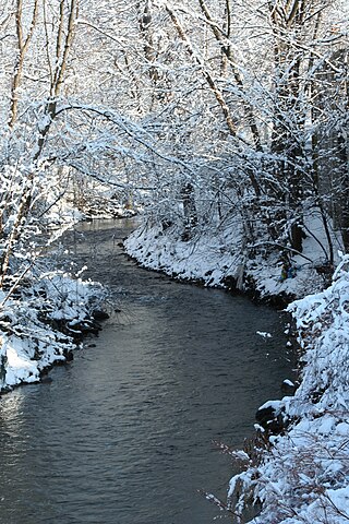
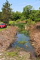
Solomon Creek is a tributary of the Susquehanna River in Luzerne County, Pennsylvania, in the United States. It is approximately 8.8 miles (14.2 km) long and flows through Fairview Township, Hanover Township, and Wilkes-Barre. The creek is affected by acid mine drainage and has significant loads of iron, aluminum, and manganese. The creek's named tributaries are Spring Run, Sugar Notch Run, and Pine Creek. The Solomon Creek watershed is located in the Anthracite Valley section of the ridge-and-valley geographical province. Major rock formations in the watershed include the Mauch Chunk Formation, the Spechty Kopf Formation, and the Catskill Formation.

<span class="mw-page-title-main">Nanticoke Creek</span> River in the United States of America

Nanticoke Creek is a tributary of the Susquehanna River in Luzerne County, Pennsylvania, in the United States. It is approximately 4.4 miles (7.1 km) long and flows through Hanover Township and Nanticoke. The watershed of the creek has an area of 7.57 square miles (19.6 km2). The creek has one named tributary, which is known as Espy Run. Nanticoke Creek impaired by pH and metals due to abandoned mine drainage. Abandoned mine drainage discharges in the creek's watershed include the Truesdale Mine Discharge and the Askam Borehole. The creek is located in the Northern Middle Anthracite Field and is in the Anthracite Valley Section of the ridge and valley physiographic province. The main rock formations in the watershed include the Mauch Chunk Formation, the Pottsville Group, and the Llewellyn Formation. The surficial geology consists of coal dumps, surface mining land, alluvium, Wisconsinan Outwash, Wisconsinan Till, urban land, and bedrock.

References

  1. "2016 U.S. Gazetteer Files". United States Census Bureau. Retrieved August 14, 2017.
  2. 1 2 3 4 Bureau, US Census. "City and Town Population Totals: 2020—2021". Census.gov. US Census Bureau. Retrieved July 24, 2022.
  3. 1 2 "Hanover Township".
  4. "National Register Information System". National Register of Historic Places . National Park Service. July 9, 2010.
  5. "Wilkes-Barre Bridge Renamed in Honor of Local Unit, 109th Field Artillery".
  6. "Hanover Township Commissioners".
  7. "Census 2020".
  8. "U.S. Census website". United States Census Bureau . Retrieved January 31, 2008.

41°12′00″N75°52′28″W / 41.20000°N 75.87444°W / 41.20000; -75.87444