Hansen Dam

Last updated

Hansen Dam
Hansen-dam01.jpg
Location map San Fernando Valley.png
Red pog.svg
Location of Hansen Dam in San Fernando Valley
CountryUnited States
LocationSan Fernando Valley
Coordinates 34°15′38″N118°23′08″W / 34.26047°N 118.38556°W / 34.26047; -118.38556
Purpose Flood control
StatusOperational
Construction began1939;84 years ago (1939)
Opening date1940;83 years ago (1940)
Owner(s) United States Army Corps of Engineers logo.svg U.S. Army Corps of Engineers, Los Angeles District
Dam and spillways
Impounds Tujunga Wash
Height97 feet (30 m)
Length2 miles (3.2 km)
Reservoir
Total capacity74,100 acre⋅ft (91,400,000 m3)
Website
Corps Lakes Gateway - Hansen Dam

Hansen Dam is a flood control dam in the northeastern San Fernando Valley, in the Lake View Terrace neighborhood of Los Angeles, California. [1] The dam was built by the U.S. Army Corps of Engineers, Los Angeles District in 1940. [2] Hansen Dam was named after horse ranchers Homer and Marie Hansen, who established a ranch in the 19th century.

Contents

The Hansen Dam Recreation Center is located in the flood control basin and surrounding slopes behind the dam. [3]

Aerial view of the Hansen Dam and Hansen Dam Golf Course (2022). HANSENDAM2022.jpg
Aerial view of the Hansen Dam and Hansen Dam Golf Course (2022).

Geography

Hansen Dam and its once-designed lake are now seasonal flood spreading grounds in the San Fernando Valley on Tujunga Wash. Tujunga Wash begins between the San Gabriel Mountains and Verdugo Mountains. The dam is 1 mile (1.6 km) downstream from the confluence of the Big Tujunga Creek and Little Tujunga Creek-Wash. The dam contains a 1,300-acre (530 ha) reservoir, which is sometimes referred to as Hansen Lake. [4] The spillway structure, outlet works and channel are located near the center of the Dam's rock embankment. The embankment itself follows a slight curve that creates a natural barrier by connecting the hills at either end of the dam. [5] It is southeast of the city of San Fernando.

Looking east along the axis of the dam, section of the spillway structure showing the cut-off wall between the spillway and the earth embankment Looking east along the axis of the dam at a section of the spillway structure showing the cut-off wall between the... - NARA - 295309.jpg
Looking east along the axis of the dam, section of the spillway structure showing the cut-off wall between the spillway and the earth embankment

History

The Los Angeles Flood of 1938, which included significant flooding along the Tujunga Wash and at its confluence with the Los Angeles River, resulted in increased support to dam and channelize the city's creeks and rivers. In 1939, due to repeated floods and the damage they caused in the eastern portions of the San Fernando Valley, the U.S. Army Corps of Engineers began the project. The Corps worked in conjunction with the Los Angeles County Flood Control District (LACFCD). They had already considered planning to implement flood risk management within the area since 1915 after a previous series of floods. [5] In 1939 the Corps, by use of eminent domain, seized the horse ranch of Homer and Marie Hansen to build the dam. [1] After a year of construction and over $11 million in initial costs, the dam and its corresponding facilities were finished. [5] The 2-mile (3.2 km) long, 97-foot (30 m) high dam was built to control the runoff and floodwaters. [6]

During storms and flooding, the dam is intended to catch water within the reservoir. Provisions in the dam's standards of operations promote water conservation efforts coordinated with the Los Angeles County Department of Public Works. The provisions allow the dam to discharge water onto spreading grounds located south of the dam, which then percolates into groundwater recharge basins and is stored as part of the city's water supply. [5]

Looking on the south side of the spillway structure and channel Hansen Dam looking northeast.jpg
Looking on the south side of the spillway structure and channel

Accumulation of debris from previous floods reduced the amount of storage capacity of the reservoir. As a result, in 1981, the Corps proposed raising the height of the dam rather than starting the expensive process of removing the build up of silt, sand, gravel and other debris. [7] The proposal did not pass, and responsibility was redirected back to the Corps providing maintenance of the dam. The Corps must occasionally excavate sediment and vegetative debris to clear clogged outlet works and maintain full capacity of the dam. [5] In the mid-1940s, the Hansen Dam Basin's recreational possibilities were considered as it attracted thousands of visitors every year. Development of recreational facilities began in 1952 with the creation of Holiday Lake, which was used by swimmers, boaters, and anglers. By 1991, the lake had become completely filled with sediment and was abandoned. [5]

Hansen Dam Recreation Area

Yucca (Hesperoyucca whipplei) blooming in upper Big Tujunga Wash Yucca in Bloom at Big Tujunga Canyon in Sunland.JPG
Yucca ( Hesperoyucca whipplei ) blooming in upper Big Tujunga Wash

The Hansen Dam Recreation Center and Park are located here, with extensive day use facilities operated by the City of Los Angeles Department of Recreation and Parks. Most facilities are accessed from Highways 5 and/or 210. [3]

The Hansen Dam Horse Park and Hansen Dam Aquatic Center are located behind the dam here, and Hansen Dam Golf Course in front. [8] [9]

Recreation Center and Park features a moderate size lake which is filled with circulated drinking water and offers fishing and public boating. The lake is open year-round, including holidays, but may be closed during times of severe weather or for planned events. Also at the site is located a smaller swim lake which features water that is filtered and chlorinated and has a capacity of 2,800 swimmers. [10]

The City of Los Angeles Department of Recreation and Parks provides lifeguards who service to the three lakes within the flood control basin. [11]

The recreation center and park areas also have: picnic tables and barbecue pits, children's play areas; and baseball diamonds and soccer fields. [3]

The park features equestrian and walking trails, that link to those exploring the nearby Angeles National Forest, and a walking pathway along the dam's top. The habitats include montane chaparral and woodlands and riparian in the rustic areas. The basin is a resource of large open space for the Los Angeles region. A large portion of the area remains undeveloped in an effort to conserve natural habitats and maintain the diverse animal and plant species. [12]

The entrance to the Discovery Cube Los Angeles located in the Hansen Dam recreation area. Discovery Cube Los Angeles.jpg
The entrance to the Discovery Cube Los Angeles located in the Hansen Dam recreation area.

The Hansen Dam Park natural area's ecology is being restored, with invasive plants removal and native plant reintroduction. [13] The proposed Rim of the Valley Trail Corridor would include Hansen Dam Park as a significant hub with trailheads. [14] [15]

The Discovery Cube Los Angeles is located at the northwest corner of the recreation area on the intersection of Osborne St. and Foothill Blvd. It was built in November 2014 and was intended to serve as an extension campus of the Discovery Cube Orange County. It has a mix of both traveling and permanent exhibits, which includes work done by the Los Angeles Bureau of Sanitation for waste reduction and resource conservation. It also has sponsored areas by the Los Angeles Department of Water and Power that educate visitors about sustainability, water conservation and preserving natural resources. [16]

In 2015, KTTV reported that unhoused people were camping at Hansen Dam as a result of California's growing housing crisis. [17] In September 2015, a $300,000 cleanup effort was initiated. [18]

Signage located within Hansen Dam Recreation Area Hansen Dam sign.jpg
Signage located within Hansen Dam Recreation Area

Recreational Assets

Hansen Dam and the riparian basin Hansen Dam, Lake View Terrace, California, United States.jpg
Hansen Dam and the riparian basin

See also

Related Research Articles

<span class="mw-page-title-main">Los Angeles River</span> River in Los Angeles County, California, US

The Los Angeles River, historically known as Paayme Paxaayt by the Tongva and the Río Porciúncula by the Spanish, is a major river in Los Angeles County, California. Its headwaters are in the Simi Hills and Santa Susana Mountains, and it flows nearly 51 miles (82 km) from Canoga Park through the San Fernando Valley, Downtown Los Angeles, and the Gateway Cities to its mouth in Long Beach, where it flows into San Pedro Bay. While the river was once free-flowing and frequently flooding, forming alluvial flood plains along its banks, it is currently notable for flowing through a concrete channel on a fixed course, which was built after a series of devastating floods in the early 20th century.

<span class="mw-page-title-main">San Fernando Valley</span> Large populated valley in Los Angeles County, California, US

The San Fernando Valley, known locally as the Valley, is an urbanized valley in Los Angeles County, California. Situated to the north of the Los Angeles Basin, it contains a large portion of the City of Los Angeles, as well as unincorporated areas and the incorporated cities of Burbank, Calabasas, Glendale, Hidden Hills, and San Fernando. The valley is well known for its iconic film studios such as Warner Bros. Studio and Walt Disney Studios. In addition, it is home to the Universal Studios Hollywood theme park.

<span class="mw-page-title-main">Sun Valley, Los Angeles</span> Neighborhood of Los Angeles in California, United States

Sun Valley is a neighborhood in Los Angeles, California in the San Fernando Valley region. The neighborhood is known for its overall youthful population and moderate racial diversity. There are three recreation centers in Sun Valley, one of which is a historic site. The neighborhood has thirteen public schools—including John H. Francis Polytechnic High School and Valley Oaks Center for Enriched Studies (VOCES)—and four private schools.

<span class="mw-page-title-main">Sepulveda Dam</span> Dam in San Fernando Valley, California

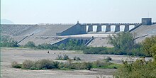
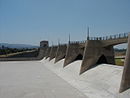
The Sepulveda Dam is a project of the U.S. Army Corps of Engineers designed to withhold winter flood waters along the Los Angeles River. Completed in 1941, at a cost of $6,650,561, it is located south of center in the San Fernando Valley, approximately eight miles east of the river's source in the western end of the Valley, in Los Angeles, California.

<span class="mw-page-title-main">San Gabriel River (California)</span> River in Los Angeles County, California, United States

The San Gabriel River is a mostly urban waterway flowing 58 miles (93 km) southward through Los Angeles and Orange Counties, California in the United States. It is the central of three major rivers draining the Greater Los Angeles Area, the others being the Los Angeles River and Santa Ana River. The river's watershed stretches from the rugged San Gabriel Mountains to the heavily developed San Gabriel Valley and a significant part of the Los Angeles coastal plain, emptying into the Pacific Ocean between the cities of Long Beach and Seal Beach.

<span class="mw-page-title-main">Lake View Terrace, Los Angeles</span> Neighborhood of Los Angeles in California, United States

Lake View Terrace is a suburban neighborhood in the San Fernando Valley region of the City of Los Angeles, California.

<span class="mw-page-title-main">Whittier Narrows</span>

The Whittier Narrows is a narrows or water gap in the San Gabriel Valley of Los Angeles County, California, United States, between the Puente Hills to the east and the Montebello Hills to the west. The gap is located at the southern boundary of the San Gabriel Valley, through which the Rio Hondo and the San Gabriel River flow to enter the Los Angeles Basin. The Narrows is located near the convergence of Interstate 605 and California State Route 60.

<span class="mw-page-title-main">Tujunga Wash</span> Stream in Los Angeles County, California, US

Tujunga Wash is a 13-mile-long (20.9 km) stream in Los Angeles County, California. It is a tributary of the Los Angeles River, providing about a fifth of its flow, and drains about 225 square miles (580 km2). It is called a wash because it is usually dry, especially the lower reaches, only carrying significant flows during and after storms, which usually only occur between November and April. The name of the wash derives from a Tongva village name.

<span class="mw-page-title-main">Canyon Lake (Texas)</span> Man-made reservoir in Texas, United States

Canyon Lake is a reservoir on the Guadalupe River in the Texas Hill Country in the United States. Canyon Lake is a U.S. Army Corps of Engineers reservoir formed on the Guadalupe River in Comal County by Canyon Dam, which is located about sixteen miles northwest of New Braunfels. The dam, lake, and all adjacent property are managed by the U.S. Army Corps Of Engineers. Water rights, waste water treatment, and hydroelectric generating facilities are managed by the Guadalupe-Blanco River Authority. Construction of the dam began in 1958 and was completed in 1964. The reservoir serves to provide flood control and water supply for the communities downstream from the dam. The lake is also a popular recreational destination.

<span class="mw-page-title-main">Los Angeles flood of 1938</span> 1938 flood in Southern California, United States

The Los Angeles flood of 1938 was one of the largest floods in the history of Los Angeles, Orange, and Riverside Counties in southern California. The flood was caused by two Pacific storms that swept across the Los Angeles Basin in February-March 1938 and generated almost one year's worth of precipitation in just a few days. Between 113–115 people were killed by the flooding. The Los Angeles, San Gabriel, and Santa Ana Rivers burst their banks, inundating much of the coastal plain, the San Fernando and San Gabriel Valleys, and the Inland Empire. Flood control structures spared parts of Los Angeles County from destruction, while Orange and Riverside Counties experienced more damage.

<span class="mw-page-title-main">Puddingstone Reservoir</span> Reservoir in Los Angeles County, California

Puddingstone Reservoir is a 250-acre (1 km²) artificial lake northeast of the interchange between the Orange Freeway and the San Bernardino Freeway in Los Angeles County, California, United States. Activities include fishing, swimming, sailing, windsurfing, and camping. It is fed by Live Oak Wash and drains into Walnut Creek.

Victory Boulevard is a major east–west arterial road that runs 25 miles (40 km) traversing the entire length of the San Fernando Valley in Los Angeles County, Southern California, United States.

The Sierra Madre Dam is a dam on Little Santa Anita Creek, at the mouth of Little Santa Anita Canyon, in Los Angeles County, California. It is in the San Gabriel Mountains, south of the Angeles National Forest, on the northern border of Sierra Madre.

<span class="mw-page-title-main">Pacoima Wash</span> River in the United States

Pacoima Wash, 33 miles (53 km) long, is a major tributary of the Tujunga Wash, itself a tributary of the Los Angeles River, in the San Fernando Valley of Los Angeles County, California.

<span class="mw-page-title-main">Santa Fe Dam</span> Dam in Irwindale, California

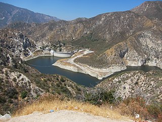
Santa Fe Dam is a flood-control dam on the San Gabriel River located in Irwindale in Los Angeles County, California, United States. For most of the year, the 92-foot (28 m)-high dam and its reservoir lie empty, but can hold more than 45,000 acre-feet (56,000,000 m3) of water during major storms. During the dry season, the basin behind the dam is used for groundwater recharge, as well as various recreational activities.

<span class="mw-page-title-main">Big Tujunga Creek</span> River in California, United States

Big Tujunga Creek is a major stream in Los Angeles County in the U.S. state of California. From its headwaters high in the San Gabriel Mountains, it flows generally southwest for 28.8 miles (46.3 km), joining Little Tujunga Creek to form the Tujunga Wash near Pacoima. The stream is sometimes considered as one with the Tujunga Wash, which is the continuation of Big Tujunga to the Los Angeles River, bringing the total length to more than 40 miles (64 km). The name of the stream is derived from a Tongva village name.

<span class="mw-page-title-main">Big Tujunga Dam</span> Dam in Los Angeles County, California

Big Tujunga Dam is a 244-foot-high (74 m) concrete arch dam in Los Angeles County, California, spanning Big Tujunga Canyon northeast of Sunland, in the foothills of the San Gabriel Mountains. Completed in 1931, it provides flood control and groundwater recharge for the San Fernando Valley.

<span class="mw-page-title-main">Mojave Forks Dam</span> Dam in Hesperia, California

The Mojave Forks Dam, most often known as the Mojave River Dam, is an earth-fill dry dam across the Mojave River in San Bernardino County, California in the United States. Completed in 1974 by the U.S. Army Corps of Engineers (USACE), the dam is located at the confluence of the West Fork Mojave River and Deep Creek, and can store approximately 179,400 acre⋅ft (221,300,000 m3) of water.

References

  1. 1 2 Pitarre, Alyson. "Where country living sidles up to the city." Los Angeles Times . June 12, 2005. 1. Retrieved March 19, 2010.
  2. "Dam Safety Program". U.S. Army Corps of Engineers. Retrieved April 7, 2014.
  3. 1 2 3 laparks: Hansen Dam recreation center . Retrieved February 1, 2012
  4. Barraclough, Laura (2011). Making the San Fernando Valley: Rural Landscapes, Urban Development, and White Privilege. University of Georgia Press. pp. 238–239.
  5. 1 2 3 4 5 6 "Hansen Dam Master Plan" (PDF). US Army Corps of Engineers. May 1, 2018.
  6. Barker, Mayerene. "Hansen Dam's Comeback Moves Slowly Recreation: Tons of silt have been hauled off, but restoration of the once-popular lake remains years away." Los Angeles Times . July 20, 1990. Metro Part B Metro Desk. Page 1. Retrieved March 19, 2010.
  7. Willman, Martha (January 3, 1982). "City Seeking Solution to Hansen Dam Debris". Los Angeles Times.
  8. Greg Wilcox (May 23, 2014). "Time to swim: Hansen Dam Aquatic Center, Burbank pools opening this weekend, others getting ready". Los Angeles Daily News . Retrieved February 2, 2020.
  9. Dana Bartholomew (February 6, 2015). "Recycled sewage water irrigates Hansen Dam Golf Course". Los Angeles Daily News . Retrieved February 2, 2020.
  10. "Hansen Dam Aquatic Center" (PDF). City of Los Angeles Department of Recreation and Parks. Summer 2013. Retrieved March 1, 2014.
  11. Shalby, Colleen (May 14, 2019). "More than 20 lifeguards develop 'swimmer's itch' after swim exam in man-made lake". Los Angeles Times . Retrieved May 15, 2019.
  12. 1 2 "Hansen Dam Park" (PDF). May 30, 2018.
  13. natural area restoration Archived February 19, 2004, at the Wayback Machine
  14. National Park Service: Rim of the Valley Corridor Study . Retrieved February 1, 2012
  15. Kamal, Sameea (March 4, 2015). "Three lawmakers urge Park Service action on Rim of the Valley study". Los Angeles Times.
  16. "Discovery Cube Los Angeles Debuts in the San Fernando Valley". Business Wire. November 13, 2014.
  17. "Homeless encampments invading the Hansen Dam area". KTTV. July 18, 2018. Retrieved February 2, 2020.
  18. Banks, Sandy (November 17, 2015). "Compassion, confusion and resentment in a city where the homeless are everywhere". Los Angeles Times . Retrieved December 7, 2018.