
Memphis is a city in the U.S. state of Tennessee. It is the seat of Shelby County, in the southwesternmost part of the state, and is situated along the Mississippi River. With a population of 633,104 at the 2020 U.S. census, Memphis is the second-most populous city in Tennessee after Nashville.

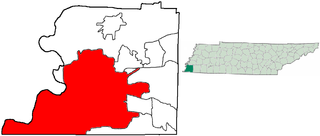
Shelby County is the westernmost county in the U.S. state of Tennessee. As of the 2020 census, the population was 929,744. It is the largest of the state's 95 counties, both in terms of population and geographic area. Its county seat is Memphis, a port on the Mississippi River and the second most populous city in Tennessee. The county was named for Governor Isaac Shelby (1750–1826) of Kentucky. It is one of only two remaining counties in Tennessee with a majority African American population, along with Haywood County.

The Memphis Pyramid, formerly known as the Great American Pyramid and the Pyramid Arena, and colloquially known as the Bass Pro Shops Pyramid, is a pyramid-shaped building located in downtown Memphis, Tennessee, United States, at the bank of the Mississippi River. Built in 1991 as a 20,142-seat arena, the facility was owned and operated jointly by the city of Memphis and Shelby County; Shelby County sold its share to Memphis in April 2009. Its structure plays on the city's namesake in Egypt, which is known for its ancient pyramids. It is 321 feet (98 m) tall and has base sides of 591 feet (180 m); it is by some measures the tenth-tallest pyramid in the world.

The Wolf River is a 105-mile-long (169 km) alluvial river in western Tennessee and northern Mississippi, whose confluence with the Mississippi River was the site of various Chickasaw, French, Spanish and American communities that eventually became Memphis, Tennessee. It is estimated to be about 12,000 years old, formed by glacier runoff carving into the region's soft alluvial soil. It should not be confused with The Wolf River which flows primarily in Middle Tennessee and southern Kentucky. The Wolf River rises in the Holly Springs National Forest at Baker's Pond in Benton County, Mississippi, and flows northwest into Tennessee, before entering the Mississippi River north of downtown Memphis.
Uptown Memphis is a neighborhood located near downtown Memphis, Tennessee. In 1999, the Uptown Partnership renamed the historic North Memphis Greenlaw neighborhood "Uptown" in concert with a public-private revitalization effort that defined Uptown as one hundred city blocks east of the Wolf River and North of A.W. Willis Avenue. The historic Greenlaw section of this neighborhood consists of the thirty city blocks closest to the Wolf River.

Downtown Memphis, Tennessee is the central business district of Memphis, Tennessee and is located along the Mississippi River between Interstate 40 to the north, Interstate 55 to the south and I-240 to the east, where it abuts Midtown Memphis.
The Wolf River Conservancy (WRC) is a non-profit 501(c)(3) organization whose stated purpose is "conserving and enhancing the Wolf River and its environs as a natural resource for public education and low-impact recreational activities." Headquartered in Memphis, Tennessee. It has approximately 1,500 members from throughout West Tennessee, led by an active Board of Directors and staff and advised by the Wolf River Conservancy Trustees. It is a fully accredited member of The Land Trust Alliance.

Mud Island is a small peninsula in Memphis, Tennessee. It is bordered by the Mississippi River to the west and the Wolf River and Harbor Town to the east. Mud Island River Park is within the Memphis city limits, 1.2 miles (1.9 km) from the coast of downtown. Mud Island includes a museum, restaurants, an amphitheater, and a residential area. It is accessible by the Memphis Suspension Railway, by foot, kayak, paddle board, or automobile. Activities on Mud Island include concerts/performances, kayaking, paddle boarding, and biking. The park is managed and operated by the Memphis River Parks Partnership. Admission to the park is free.
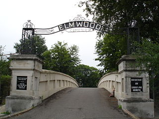
Elmwood Cemetery is the oldest active cemetery in Memphis, Tennessee. It was established in 1852 as one of the first rural cemeteries in the South.

The Memphis Suspension Railway, Mud Island Monorail, or Memphis Monorail was a suspended monorail that connects the city center of Memphis with the entertainment park on Mud Island. Celebrating its grand opening on July 3, 1982, it was located beneath a footbridge over the Wolf River Lagoon connecting to the southern tip of Mud Island. In 2018, multiple malfunctions occurred during passenger service, one of which required the fire department to attend to stranded passengers, and finally the motor failed.
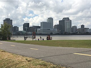
The City of Memphis is located on the eastern bank of the Mississippi River in the southwest corner of the U.S. state of Tennessee. It is the regional hub for a tri-state area of Arkansas, Mississippi and Tennessee.
The steamboat Pennsylvania was a side wheeler steamboat which suffered a boiler explosion in the Mississippi River and sank at Ship Island near Memphis, Tennessee, on June 13, 1858.
Looney Ricks Kiss is a Memphis-based full-service architecture firm founded in 1983 by Carson Looney, FAIA, Frank Ricks, FAIA, and Richard Kiss, AIA. In addition to architecture, its services include planning, interior architecture and environmental graphic design. LRK is known for a variety of projects including the Urban Land Institute Award of Excellence honored AutoZone Park and Harbor Town.

Randolph is a rural unincorporated community in Tipton County, Tennessee, United States, located on the banks of the Mississippi River. Randolph was founded in the 1820s and in 1827, the Randolph post office was established. In the 1830s, the town became an early center of river commerce in West Tennessee. Randolph shipped more cotton annually than Memphis until 1840. In 1834, the first pastor of the Methodist congregation was appointed. The fortunes of the community began to decline in the late 1840s due to failed railroad development, an unfavorable mail route and other factors. The first Confederate States Army fort in Tennessee was built at Randolph early in the Civil War in 1861, a second fortification at Randolph was constructed later that same year. During the Civil War, the town was burned down twice by Union Army forces.
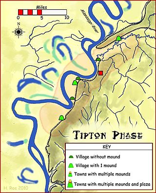
Randolph is an unincorporated rural community in Tipton County, Tennessee, United States, located on the banks of the Mississippi River. The lands of the Mississippi River Basin were inhabited by Paleo-Indians and later Native American tribes of the Mississippian culture for thousands of years. The Tipton phase people and the Chickasaw Indian tribe populated the Mississippi River valley near Randolph during the Mississippian period. In 1541, Spanish explorer Hernando de Soto crossed the Mississippi River at or near Randolph. French explorer Cavelier de La Salle built the first French fortification at or near Randolph on his 1682 canoe expedition of the Mississippi River.
The Mississippi River Trail is a designated bicycle and pedestrian trail that traverses the shores of the Mississippi River in the United States. The trail extends from the headwaters at Lake Itasca in Minnesota to near the mouth of the river in Venice, Louisiana. Much of the trail’s 3,000 miles (4,800 km) follows roadways used by motor vehicles, although some of the route is on multi-use trails. The segment in Minnesota has been designated as U.S. Bicycle Route 45, part of the U.S. Bicycle Route System.

The Pinch District is a historical district of downtown Memphis roughly bordered by the Wolf River lagoon on the west, Market Street on the south, Danny Thomas Boulevard on the east, and A.W. Willis Avenue on the north.

Northaven is an unincorporated community located in north Shelby County, Tennessee, United States, that is a part of the Memphis metropolitan area. Tennessee State Route 388 connects Northaven with Frayser and Shelby Forest. The Mississippi River Trail runs through the neighborhood.

Roy Perkins Harrover, FAIA was an American architect who designed the Memphis International Airport as well as numerous civic buildings across the southern United States. His designs range in style from New Formalist to Brutalist and are characterized by their strictly linear forms. He is largely credited with having established a modern architectural identity for Memphis, Tennessee.

South Bluffs is a gated neighborhood located south of Downtown Memphis, Tennessee. The bluff was previously occupied by a 25-acre (10 ha) railroad and switching yard, until 1989 when ground was broken on developing a residential neighborhood. The location of the neighborhood and the views of the Mississippi River have drawn Memphians, such as Pat Halloran and Henry Turley, to purchase homes within the neighborhood.


