Harlem, Florida

Last updated

Harlem, Florida
Hendry County Florida Incorporated and Unincorporated areas Harlem Highlighted.svg
Location in Hendry County and the state of Florida
Coordinates: 26°44′8″N80°57′5″W / 26.73556°N 80.95139°W / 26.73556; -80.95139
Country Flag of the United States.svg  United States
State Flag of Florida.svg  Florida
County   Hendry
Area
[1]
  Total1.05 sq mi (2.73 km2)
  Land1.05 sq mi (2.73 km2)
  Water0.00 sq mi (0.00 km2)
Elevation
20 ft (6 m)
Time zone UTC-5 (Eastern (EST))
  Summer (DST) UTC-4 (EDT)
ZIP code
33440 [2]
Area code 863
FIPS code 12-28925 [3]
GNIS feature ID0283738 [4]

Harlem is a census-designated place (CDP) in Hendry County, Florida, United States. It was established in 1931. Its population is predominantly African American. The population was 2,441 at the 2020 census, down from 2,658 at the 2010 census. It is part of the Clewiston, Florida Micropolitan Statistical Area (μSA).

Contents

Geography

Harlem is located in northeastern Hendry County at 26°44′8″N80°57′5″W / 26.73556°N 80.95139°W / 26.73556; -80.95139 (26.735457, -80.951462). [5] It is bordered to the north by the city of Clewiston. According to the United States Census Bureau, the CDP has a total area of 1.06 square miles (2.75 km2), all land. [6]

Demographics

Historical population
CensusPop.Note
1990 2,826
2000 2,730−3.4%
2010 2,658−2.6%
2020 2,441−8.2%
U.S. Decennial Census [7]

2020 census

Harlem, Florida – Racial and ethnic composition
Note: the US Census treats Hispanic/Latino as an ethnic category. This table excludes Latinos from the racial categories and assigns them to a separate category. Hispanics/Latinos may be of any race.
Race / Ethnicity (NH = Non-Hispanic)Pop 2000 [8] Pop 2010 [9] Pop 2020 [10] % 2000% 2010% 2020
White alone (NH)2924391.06%0.90%1.60%
Black or African American alone (NH)2,5872,5392,28994.76%95.52%93.77%
Native American or Alaska Native alone (NH)5460.18%0.15%0.25%
Asian alone (NH)1100.04%0.04%0.00%
Pacific Islander alone (NH)0000.00%0.00%0.00%
Some Other Race alone (NH)0000.00%0.00%0.00%
Mixed race or Multiracial (NH)369251.32%0.34%1.02%
Hispanic or Latino (any race)7281822.64%3.05%3.36%
Total2,7302,6582,441100.00%100.00%100.00%

2000 census

As of the census [3] of 2000, there were 2,730 people, 877 households, and 644 families residing in the CDP. The population density was 2,820.9 inhabitants per square mile (1,089.2/km2). There were 926 housing units at an average density of 956.8 per square mile (369.4/km2). The racial makeup of the CDP was 95.38% African American, 2.31% White, 0.18% Native American, 0.11% Asian, 0.51% from other races, and 1.50% from two or more races. Hispanic or Latino of any race were 2.64% of the population.

There were 877 households, out of which 43.6% had children under the age of 18 living with them, 31.9% were [married couples living together, 35.1% had a female householder with no husband present, and 26.5% were non-families. 22.6% of all households were made up of individuals, and 7.6% had someone living alone who was 65 years of age or older. The average household size was 3.11 and the average family size was 3.67.

In the CDP, the population was spread out, with 39.5% under the age of 18, 10.0% from 18 to 24, 24.1% from 25 to 44, 18.1% from 45 to 64, and 8.3% who were 65 years of age or older. The median age was 25 years. For every 100 females, there were 88.5 males. For every 100 females age 18 and over, there were 78.0 males.

The median income for a household in the CDP was $21,232, and the median income for a family was $22,574. Males had a median income of $21,771 versus $20,156 for females. The per capita income for the CDP was $11,571. About 31.2% of families and 40.4% of the population were below the poverty line, including 58.6% of those under age 18 and 23.0% of those age 65 or over.

Related Research Articles

<span class="mw-page-title-main">Hendry County, Florida</span> County in Florida, United States

Hendry County is a county in the Florida Heartland region of the U.S. state of Florida. As of the 2020 census, the population was 39,619, down from 42,022 at the 2010 census. Its county seat is LaBelle.

<span class="mw-page-title-main">Goulding, Florida</span> Census-designated place in Florida, United States

Goulding is a census-designated place (CDP) in Escambia County, Florida, United States. The population was 4,102 at the 2010 census. It is part of the Pensacola–Ferry Pass–Brent Metropolitan Statistical Area.

<span class="mw-page-title-main">Clewiston, Florida</span> City in Florida, United States

Clewiston is a city in Hendry County, Florida, United States. Its location is 80 miles (130 km) northwest of Fort Lauderdale on the Atlantic coastal plain. The population was 7,327 at the 2020 census, up from 7,155 at the 2010 census. It is the principal city in the Clewiston, Florida Micropolitan Statistical Area (μSA).

<span class="mw-page-title-main">Port LaBelle, Florida</span> Census-designated place in Florida, United States

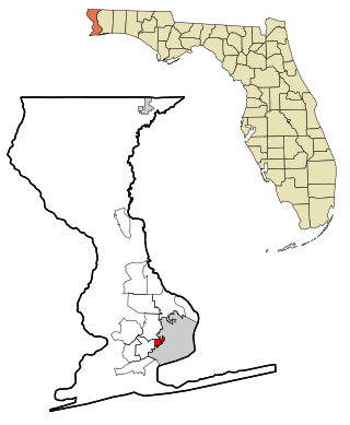
Port LaBelle is a census-designated place (CDP) in Hendry and Glades counties, Florida, United States. The population was 5,450 at the 2020 census, up from 3,530 at the 2010 census. It is part of the Clewiston, Florida Micropolitan Statistical Area (μSA).

<span class="mw-page-title-main">Coral Terrace, Florida</span> Census-designated place in Florida

Coral Terrace is a suburban unincorporated community and census-designated place (CDP) in Miami-Dade County, Florida, United States. It is part of the Miami metropolitan area of South Florida. The population was 23,142 at the 2020 census, down from 24,376 in 2010.

<span class="mw-page-title-main">Gladeview, Florida</span> Census-designated place in Florida

Gladeview is a census-designated place (CDP) in Miami-Dade County, Florida, United States. It is part of the Miami metropolitan area of South Florida. The population was 14,927 at the 2020 census, up from 11,535 in 2010.

<span class="mw-page-title-main">Homestead Base, Florida</span> Census-designated place in Florida

Homestead Base is a census-designated place (CDP) in Miami-Dade County, Florida, United States. The CDP comprises the extent of Homestead Air Reserve Base plus some surrounding land. It is part of the Miami metropolitan area of South Florida. The population was 999 at the 2020 census.

<span class="mw-page-title-main">Leisure City, Florida</span> Census-designated place in Florida

Leisure City is an unincorporated community and census-designated place (CDP) in Miami-Dade County, Florida, United States, that includes the smaller, older community of Modello in its northwestern section. The CDP is most notable for the Coral Castle Museum, located in the Modello area. It is located in the Miami metropolitan area of South Florida. The population was 26,324 at the 2020 census, up from 22,655 in 2010.

<span class="mw-page-title-main">Palmetto Estates, Florida</span> Census-designated place in Florida

Palmetto Estates is an unincorporated area and census-designated place (CDP) in Miami-Dade County, Florida, United States. It is part of the Miami metropolitan area of South Florida. The population was 13,498 at the 2020 census.

<span class="mw-page-title-main">Princeton, Florida</span> Census-designated place in Florida

Princeton is a census-designated place (CDP) and unincorporated community in Miami-Dade County, Florida, United States. It is part of the Miami metropolitan area of South Florida. The population was 39,208 at the 2020 census, up from 22,038 at the 2010 census.

<span class="mw-page-title-main">Sunset, Florida</span> Census-designated place in Florida

Sunset is a census-designated place (CDP) in Miami-Dade County, Florida, United States. It is part of the Miami metropolitan area of South Florida. The population was 15,912 at the 2020 census. The U.S. Postal Service uses the ZIP Codes of 33173 and 33183 for Sunset.

<span class="mw-page-title-main">The Crossings, Florida</span> CDP in Florida

The Crossings is a census-designated place (CDP) and suburb of Miami in Miami-Dade County, Florida, United States. It is part of the Miami metropolitan area of South Florida. The CDP includes the neighborhoods of The Crossings, Devon Aire, and Calusa. The population was 23,276 at the 2020 census.

<span class="mw-page-title-main">Three Lakes, Florida</span> Census-designated place in Florida

Three Lakes is a census-designated place (CDP) and planned community in Miami-Dade County, Florida, United States. It is part of the Miami metropolitan area of South Florida. The population was 16,540 at the 2020 census, up from 15,047 in 2010.

<span class="mw-page-title-main">West Perrine, Florida</span> Census-designated place in Florida

West Perrine is a census-designated place (CDP) in Miami-Dade County, Florida, United States. It is part of the Miami metropolitan area of South Florida. The population was 10,602 at the 2020 census, up from 9,460 in 2010.

<span class="mw-page-title-main">Westview, Florida</span> Census-designated place in Florida

Westview is a census-designated place (CDP) in Miami-Dade County, Florida, United States. It is part of the Miami metropolitan area of South Florida. The population was 9,923 at the 2020 census.

<span class="mw-page-title-main">Cypress Quarters, Florida</span> CDP in Florida, United States

Cypress Quarters is a census-designated place (CDP) in Okeechobee County, Florida, United States. The population was 1,215 at the 2010 census.

Limestone Creek is a census-designated place (CDP) in Palm Beach County, Florida, United States. It is part of the Miami metropolitan area of South Florida. The population was 1,316 at the 2020 US census.

Stacy Street is a residential street and surrounding census-designated place (CDP) in Palm Beach County, Florida, United States. In the 2010 and 2020 US Census, the CDP is misspelled as Stacey Street. It is part of the Miami metropolitan area of South Florida. The population was 978 at the 2020 US census.

<span class="mw-page-title-main">South Miami Heights, Florida</span> Census-designated place in Florida

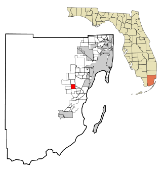
South Miami Heights is a census-designated place (CDP), originally known as Eureka, in Miami-Dade County, Florida. It is part of the Miami metropolitan area of South Florida. The population was 36,770 as of the 2020 census.

<span class="mw-page-title-main">LaBelle, Florida</span> City in Florida, United States

LaBelle is a city in and the county seat of Hendry County, Florida, United States. The population was 4,966 at the 2020 census, up from 4,640 at the 2010 census. It is part of the Clewiston, FL Micropolitan Statistical Area (μSA).

References

  1. "2020 U.S. Gazetteer Files". United States Census Bureau. Retrieved October 31, 2021.
  2. "Harlem FL ZIP Code". zipdatamaps.com. 2023. Retrieved February 17, 2023.
  3. 1 2 "U.S. Census website". United States Census Bureau . Retrieved January 31, 2008.
  4. "US Board on Geographic Names". United States Geological Survey. October 25, 2007. Retrieved January 31, 2008.
  5. "US Gazetteer files: 2010, 2000, and 1990". United States Census Bureau. February 12, 2011. Retrieved April 23, 2011.
  6. "Geographic Identifiers: 2010 Demographic Profile Data (G001): Harlem CDP, Florida". American Factfinder. U.S. Census Bureau. Retrieved April 26, 2017.[ dead link ]
  7. "Census of Population and Housing". Census.gov. Retrieved June 4, 2016.
  8. "P004 Hispanic or Latino, and Not Hispanic or Latino by Race – 2000: DEC Summary File 1 – Harlem CDP, Florida". United States Census Bureau.
  9. "P2: Hispanic or Latino, and Not Hispanic or Latino by Race – 2010: DEC Redistricting Data (PL 94-171) – Harlem CDP, Florida". United States Census Bureau.
  10. "P2: Hispanic or Latino, and Not Hispanic or Latino by Race – 2020: DEC Redistricting Data (PL 94-171) – Harlem CDP, Florida". United States Census Bureau.