Harrisville, New Hampshire

Last updated

Harrisville, New Hampshire
Town
Harrisville NH.jpg
The historic mill village of Harrisville
Cheshire-Harrisville-NH.png
Coordinates: 42°56′42″N72°05′47″W / 42.94500°N 72.09639°W / 42.94500; -72.09639
Country United States
State New Hampshire
County Cheshire
Incorporated 1870
Villages
Government
   Board of Selectmen
  • Andrew Maneval, Chair
  • Kathleen Scott
  • Andrea Hodson
Area
[1]
  Total20.2 sq mi (52.4 km2)
  Land18.6 sq mi (48.3 km2)
  Water1.6 sq mi (4.1 km2)  7.79%
Elevation
1,335 ft (407 m)
Population
 (2020) [2]
  Total984
  Density53/sq mi (20.4/km2)
Time zone UTC-5 (Eastern)
  Summer (DST) UTC-4 (Eastern)
ZIP code
03450
Area code 603
FIPS code 33-34420
GNIS feature ID0873620
Website www.harrisvillenh.org

Harrisville is a town in Cheshire County, New Hampshire, United States. Besides the town center, it also includes the villages of Chesham and Eastview. The population of the town was 984 at the 2020 census. [2]

Contents

It is a preserved 19th-century mill town located in the Monadnock region of southern New Hampshire. There are nine bodies of water in the town, many back roads and trails to explore, and two original train depots at Harrisville and Chesham.

History

First known as "Twitchell's Mills", a combination sawmill and gristmill was built here in 1774. The town of Harrisville was formed in 1870 from lands ceded by Marlborough, Dublin, Hancock, Nelson, and Roxbury. The Manchester & Keene Railroad opened in 1878, helping it prosper as a textile mill town. [3] It was named for Milan Harris, whose stone and brick Cheshire Mills operated until 1970, but look virtually unchanged since the mid-19th century. [4]

Today, the Cheshire Mills are protected as part of the Harrisville Historic District, a National Historic Landmark which includes the center of town. With its red brick buildings and mills reflected in Harrisville Pond and canal, the village is frequently photographed as an iconic example of picturesque old New England. [5] The Harrisville Rural District includes the southern part of the town near the Dublin border.

Geography

According to the United States Census Bureau, the town has a total area of 20.2 square miles (52.4 km2), of which 18.6 square miles (48.3 km2) are land and 1.6 square miles (4.1 km2) are water, comprising 7.79% of the town. [1] The highest point in Harrisville is the summit of Cobb Hill, at 1,909 feet (582 m) above sea level. Roughly the western half of Harrisville, drained by Minnewawa Brook, lies within the Ashuelot River watershed, part of the Connecticut River basin, while the eastern half, drained by Nubanusit Brook, is in the Contoocook River watershed, part of the Merrimack River basin. [6] Significant water bodies include Silver Lake, Seaver Reservoir, and Chesham Pond on the western side, and Harrisville Pond and Skatutakee Lake draining to the east. [7]

Adjacent municipalities

Churches

The Community Church of Harrisville and Chesham was formed from Chesham Baptist Church and Harrisville Congregational Church. Chesham Baptist Church dates back to 1785. The church building was originally built in 1797, re-modeled in 1830, and again re-modeled in 1844. The Evangelical Congregational Church of Harrisville dates back to 1840, and the church building was erected in 1840–1843.

The Community Church is a member of the United Church of Christ (UCC) and the American Baptist Association, and it retains a united congregation using only the brick church in Harrisville village. The church in Chesham is owned by the American Baptist Association of Vermont & New Hampshire and is no longer used by the Community Church of Harrisville & Chesham.

Harrisville was home to St. Denis Parish of the Roman Catholic Church from 1902 to 2010, when services ended following the merger with Saint Peter Parish in Peterborough and Saint Patrick Parish in Bennington. [8] The church building is now owned by Historic Harrisville and is referred to as St. Denis Hall. [9]

Demographics

Historical population
CensusPop.Note
1880 870
1890 748−14.0%
1900 7915.7%
1910 623−21.2%
1920 559−10.3%
1930 512−8.4%
1940 509−0.6%
1950 5192.0%
1960 459−11.6%
1970 58427.2%
1980 86047.3%
1990 98114.1%
2000 1,0759.6%
2010 961−10.6%
2020 9842.4%
U.S. Decennial Census [2] [10]

At the 2000 census, [11] there were 1,075 people, 449 households and 306 families residing in the town. The population density was 57.4 per square mile (22.2/km2). There were 698 housing units at an average density of 37.2 per square mile (14.4/km2). The racial make-up of the town was 97.77% White, 0.09% African American, 0.56% Native American, 0.28% Asian and 1.30% from two or more races. Hispanic or Latino of any race were 0.56% of the population.

There were 449 households of which 31.2% had children under the age of 18 living with them, 55.2% were married couples living together, 8.9% had a female householder with no husband present and 31.8% were non-families. 26.5% of all households were made up of individuals and 7.8% had someone living alone who was 65 years of age or older. The average household size was 2.39 and the average family size was 2.87.

24.8% of the population were under the age of 18, 4.6% from 18 to 24, 25.7% from 25 to 44, 30.0% from 45 to 64 and 15.0% were 65 years of age or older. The median age was 43 years. For every 100 females, there were 92.3 males. For every 100 females age 18 and over, there were 87.0 males.

The median household income was $48,625 and the median family income was $55,083. Males had a median income of $34,625 and females $27,171. The per capita income was $25,397. About 4.3% of families and 5.7% of the population were below the poverty line, including 8.0% of those under age 18 and 3.8% of those age 65 or over.

Education

The elementary school is Wells Memorial School in Chesham.

Related Research Articles

<span class="mw-page-title-main">Cheshire County, New Hampshire</span> County in New Hampshire, United States

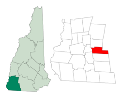
Cheshire County is a county in the southwestern corner of the U.S. state of New Hampshire. As of the 2020 census, the population was 76,458. Its county seat is the city of Keene. Cheshire was one of the five original counties of New Hampshire, and is named for the county of Cheshire in England. It was organized in 1771 at Keene. Sullivan County was created from the northern portion of Cheshire County in 1827.

<span class="mw-page-title-main">Cheshire, Massachusetts</span> Town in Massachusetts, United States

Cheshire is a town in Berkshire County, Massachusetts, United States. It is part of the Pittsfield, Massachusetts Metropolitan Statistical Area. The population was 3,258 at the 2020 census.

<span class="mw-page-title-main">Chesterfield, New Hampshire</span> Town in New Hampshire, United States

Chesterfield is a town in Cheshire County, New Hampshire, United States. The population was 3,552 at the 2020 census. It includes the villages of Spofford and West Chesterfield. Chesterfield is home to Spofford Lake, Chesterfield Gorge Natural Area, and parts of Pisgah State Park and Wantastiquet Mountain State Forest.

<span class="mw-page-title-main">Dublin, New Hampshire</span> Town in New Hampshire, United States

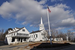
Dublin is a town in Cheshire County, New Hampshire, United States. The population was 1,532 at the 2020 census. It is home to Dublin School and Yankee magazine.

<span class="mw-page-title-main">Gilsum, New Hampshire</span> Town in New Hampshire, United States

Gilsum is a town in Cheshire County, New Hampshire, United States. The population was 752 at the 2020 census. Home to Bear's Den Natural Area, Gilsum includes Gilsum Lower Village.

<span class="mw-page-title-main">Nelson, New Hampshire</span> Town in New Hampshire, United States

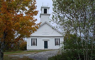
Nelson is a town in Cheshire County, New Hampshire, United States. The population was 629 at the 2020 census, down from 729 at the 2010 census. Nelson includes the village of Munsonville.

<span class="mw-page-title-main">Richmond, New Hampshire</span> Town in New Hampshire, United States

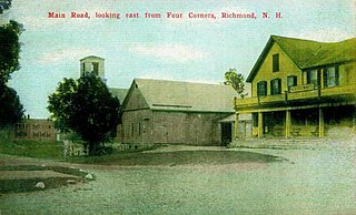
Richmond is a town in Cheshire County, New Hampshire, United States. The population was 1,197 at the 2020 census.

<span class="mw-page-title-main">Rindge, New Hampshire</span> Town in New Hampshire, United States

Rindge is a town in Cheshire County, New Hampshire, United States. The population was 6,476 at the 2020 census, up from 6,014 at the 2010 census. Rindge is home to Franklin Pierce University, the Cathedral of the Pines and part of Annett State Forest.

<span class="mw-page-title-main">Roxbury, New Hampshire</span> Town in New Hampshire, United States

Roxbury is a town in Cheshire County, New Hampshire, United States. The population was 220 at the 2020 census.

<span class="mw-page-title-main">Troy, New Hampshire</span> Town in New Hampshire, United States

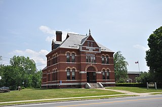
Troy is a town in Cheshire County, New Hampshire, United States. The population was 2,130 at the 2020 census. It is situated west of Mount Monadnock.

<span class="mw-page-title-main">Greenfield, New Hampshire</span> Town in New Hampshire, United States

Greenfield is a town in Hillsborough County, New Hampshire, United States. The population was 1,716 at the 2020 census. Greenfield is home to the Crotched Mountain Rehabilitation Center, to Greenfield State Park, and to part of the Wapack Trail.

<span class="mw-page-title-main">Hancock, New Hampshire</span> Town in New Hampshire, United States

Hancock is a town in Hillsborough County, New Hampshire, United States. The population was 1,731 at the 2020 census. Hancock is home to the Welch Family Farm Forest.

<span class="mw-page-title-main">Danville, New Hampshire</span> Town in New Hampshire, United States

Danville is a town in Rockingham County, New Hampshire, United States. The population was 4,408 at the 2020 census. Danville is part of the Timberlane Regional School District, with students attending Danville Elementary School, Timberlane Regional Middle School, and Timberlane Regional High School.

<span class="mw-page-title-main">New Durham, New Hampshire</span> Town in New Hampshire, United States

New Durham is a town in Strafford County, New Hampshire, United States. The population was 2,693 at the 2020 census. It is drained by the Merrymeeting, Cocheco and Ela rivers, and is known for Merrymeeting Lake. New Durham is home to the Powder Mill Fish Hatchery, located on Merrymeeting Road. Also located here is the Lions Club's Camp Pride, a camp for children and adults with special needs.

<span class="mw-page-title-main">Cornish, New Hampshire</span> Town in New Hampshire, United States

Cornish is a town in Sullivan County, New Hampshire, United States. The population was 1,616 at the 2020 census. Cornish has four covered bridges. Each August, it is home to the Cornish Fair.

Harrisville is a hamlet and former village in Lewis County, New York, United States. The community is now a census-designated place. The population was 628 at the 2010 census.

<span class="mw-page-title-main">Jaffrey, New Hampshire</span> Town in New Hampshire, United States

Jaffrey is a town in Cheshire County, New Hampshire, United States. The population was 5,320 at the 2020 census.

<span class="mw-page-title-main">Marlborough, New Hampshire</span> Town in New Hampshire, United States

Marlborough is a town in Cheshire County, New Hampshire, United States. The population was 2,096 at the 2020 census. The town is home to the Kensan-Devan Wildlife Sanctuary at Meetinghouse Pond.

<span class="mw-page-title-main">Winchester, New Hampshire</span> Town in New Hampshire, United States

Winchester is a town in Cheshire County, New Hampshire, United States. The population was 4,150 at the 2020 census. The primary community in the town, where 1,606 people resided at the 2020 census, is defined by the U.S. Census Bureau as the Winchester census-designated place (CDP). The town also includes the village of Ashuelot and part of Pisgah State Park.

<span class="mw-page-title-main">Antrim, New Hampshire</span> Town in New Hampshire, United States

Antrim is a town in Hillsborough County, New Hampshire, United States. The population was 2,651 at the 2020 census. The main village in the town, where 1,395 people lived at the 2020 census, is defined as the Antrim census-designated place (CDP) and is located at the intersection of U.S. Route 202 and New Hampshire Route 31. The town of Antrim also includes the villages of Antrim Center, North Branch, and Clinton Village.

References

  1. 1 2 "2021 U.S. Gazetteer Files – New Hampshire". United States Census Bureau. Retrieved November 3, 2021.
  2. 1 2 3 "Harrisville town, Cheshire County, New Hampshire: 2020 DEC Redistricting Data (PL 94-171)". U.S. Census Bureau. Retrieved November 3, 2021.
  3. Harrisville Railroad Depot, Harrisville, New Hampshire
  4. History of Harrisville, Cheshire County, New Hampshire
  5. "History of Harrisville". Archived from the original on March 25, 2006. Retrieved March 16, 2006.
  6. Foster, Debra H.; Batorfalvy, Tatianna N.; Medalie, Laura (1995). Water Use in New Hampshire: An Activities Guide for Teachers. U.S. Department of the Interior and U.S. Geological Survey.
  7. U.S. Geological Survey. Dublin, NH 1:25,000-scale quadrangle, 1984
  8. Decree Archived May 12, 2014, at the Wayback Machine "Merging Saint Peter Parish in Peterborough, New Hampshire, Saint Patrick Parish in Bennington, New Hampshire and Saint Denis Parish in Harrisville, New Hampshire, to form one new canonical person", Diocese of Manchester NH, June 25, 2006.
  9. St. Denis Catholic Church, Historic Harrisville.
  10. "Census of Population and Housing". Census.gov. Retrieved June 4, 2016.
  11. "U.S. Census website". United States Census Bureau . Retrieved January 31, 2008.