Havering London Borough Council | |
---|---|
Type | |
Type | |
History | |
Founded | 1 April 1965 |
Leadership | |
Andrew Blake-Herbert since 31 March 2016 [1] | |
Structure | |
Seats | 55 Councillors |
Political groups |
|
Committees | 7
|
Joint committees | Thames Chase Joint Committee Thames Gateway London Partnership East London Waste Authority London Councils |
Length of term | Whole council elected every four years |
Elections | |
Plurality-at-large | |
Last election | 5 May 2022 |
Next election | 7 May 2026 |
Motto | |
Liberty | |
Meeting place | |
Havering Town Hall, Main Road, Romford, RM1 3BB | |
Website | |
www | |
Constitution | |
Constitution |
Havering London Borough Council, also known as Havering Council, is the local authority for the London Borough of Havering in Greater London, England. It is a London borough council, one of 32 in London. The council has been under no overall control since 2014; since 2022 it has been run by a coalition of the Havering Residents Association and Labour. The council is based at Havering Town Hall in Romford.
The borough was created in 1965 under the London Government Act 1963, covering the combined area of the former Municipal Borough of Romford and Hornchurch Urban District. The area was transferred from Essex to Greater London to become one of the 32 London Boroughs. [2]
Romford had been a local board district from 1851. [3] It was converted into an urban district in 1894, was enlarged in 1934 to take in the neighbouring parishes of Havering-atte-Bower and Noak Hill, and was incorporated to become a municipal borough in 1937. [4] The parish of Hornchurch had been made an urban district in 1926, which was enlarged in 1934 to take in the parishes of Cranham, Great Warley, Rainham, Upminster and Wennington. [5]
The new borough was named after the former Royal Liberty of Havering, which had covered a similar area. The council's full legal name is "The Mayor and Burgesses of the London Borough of Havering". [6]
From 1965 until 1986 the council was a lower-tier authority, with upper-tier functions provided by the Greater London Council. The split of powers and functions meant that the Greater London Council was responsible for "wide area" services such as fire, ambulance, flood prevention, and refuse disposal; with the boroughs (including Havering) responsible for "personal" services such as social care, libraries, cemeteries and refuse collection. As an outer London borough council Havering has been a local education authority since 1965. The Greater London Council was abolished in 1986 and its functions passed to the London Boroughs, with some services provided through joint committees. [7]
Since 2000 the Greater London Authority has taken some responsibility for highways and planning control from the council, but within the English local government system the council remains a "most purpose" authority in terms of the available range of powers and functions. [8]
In September 2023, the leader of the council warned the authority could be six months away from triggering a Section 114 notice because of the increasing cost of social care and housing. [9] [10] The council managed to set a budget in 2024, but only through relying on an exceptional £54 million loan from the government. [11]
The local authority derives its powers and functions from the London Government Act 1963 and subsequent legislation, and has the powers and functions of a London borough council. It sets council tax and as a billing authority also collects precepts for Greater London Authority functions plus levies on behalf of the East London Waste Authority, the Lee Valley Regional Park Authority and others. [12] [13] It sets planning policies which complement Greater London Authority and national policies, and decides on almost all planning applications accordingly. It is a local education authority and is also responsible for council housing, social services, libraries, waste collection and disposal, traffic, and most roads and environmental health. [14]
The council has been under no overall control since 2014.
The first election was held in 1964, initially operating as a shadow authority alongside the outgoing authorities until it came into its powers on 1 April 1965. Political control of the council since 1965 has been as follows: [15]
Party in control | Years | |
---|---|---|
No overall control | 1965–1968 | |
Conservative | 1968–1971 | |
Labour | 1971–1974 | |
No overall control | 1974–1978 | |
Conservative | 1978–1986 | |
No overall control | 1986–2006 | |
Conservative | 2006–2014 | |
No overall control | 2014–present |
The role of mayor in Havering is largely ceremonial, usually being held by a different councillor each year. Political leadership is instead provided by the leader of the council. The leaders since 1965 have been: [16] [17]
Councillor | Image | Party | From | To | |
---|---|---|---|---|---|
Jack Moultrie | Conservative | 1965 | 1971 | ||
Michael Ward | Labour | 1971 | 1974 | ||
Jack Moultrie | Conservative | 1974 | 1977 | ||
William Sibley | Conservative | 1977 | 1978 | ||
Jack Moultrie | Conservative | 1978 | 1984 | ||
Roger Ramsey | Conservative | 1984 | 1990 | ||
Arthur Latham | Labour | 1990 | 1996 | ||
Louise Sinclair | Residents' Association | 1996 | 1997 | ||
Wilf Mills | Labour | 1997 | 1998 | ||
Ray Harris | Labour | 1998 | 2002 | ||
Eric Munday | Conservative | 2002 | 2004 | ||
Michael White | Conservative | 2004 | 29 Jan 2014 | ||
Steven Kelly | Conservative | 29 Jan 2004 | 11 Jun 2014 | ||
Roger Ramsey | Conservative | 11 Jun 2014 | 23 May 2018 | ||
Damian White | Conservative | 23 May 2018 | 25 May 2022 | ||
Ray Morgon | Havering Residents Association | 25 May 2022 |
Following the 2022 election and a subsequent by-election and changes of allegiance up to April 2024, the composition of the council was:
Party | Councillors | |
---|---|---|
Havering Residents Association | 25 | |
Conservative | 16 | |
Labour | 9 | |
Residents Association | 3 | |
Independent | 2 | |
Total | 55 |
The Havering Residents Association is registered as a political party with the Electoral Commission, but is also an umbrella group covering several other residents associations which are also registered as parties. Some of the association's councillors stood directly as candidates for it, others stood as candidates for the other associations, including the Hornchurch Residents Association, Rainham Independent Residents Association and Upminster and Cranham Residents Association. The group also includes seven councillors elected in 2022 as Conservatives who subsequently defected. [18] [19] [20] The other three councillors elected for a residents association were all elected for the Harold Wood Hill Park Residents Association, which does not form part of the Havering Residents Association; those three councillors sit together as the East Havering Residents Group. The two independent councillors (both elected for the Upminster and Cranham Residents Association) left the Havering Residents Association group and sit together as the Residents Associations Independent Group. [21] [19] [22] The next election is due in 2026.
The council is based at Havering Town Hall on Main Road in Romford, which was completed in 1937 as 'Romford Town Hall' for the old Romford Urban District Council. It was formally opened on 16 September 1937, on which day Romford was also presented with its charter of incorporation turning the urban district into a borough. [23] The building was subsequently extended in 1960 and 1988. [24]
Since the last boundary changes in 2022 the council has comprised 55 councillors representing 20 wards, with each ward electing two or three councillors. Elections are held every four years. [25]
As part of the process of reviewing the boundaries leading up to the 2022 changes, there were accusations that the Conservative administration was attempting to gerrymander the new boundaries. The council's then leader, Damian White, was secretly recorded outlining plans to modify ward boundaries to the advantage of the party. White reportedly said the Local Government Boundary Commission had so few staff it was "highly unlikely they'll put in the effort" to scrutinise the changes and that "they only look at what was discussed... at the full council meeting. So there will be only one option." [26] Following the emergence of the recording there was a local outcry. The Local Government Boundary Commission consequently revised its proposals for the new wards and carried out further public consultation, which led to notable changes in the final boundaries from the earlier draft proposals. [27]
The current composition of Havering Council's Cabinet is as follows.
Party key | Havering Residents Association | |
---|---|---|
Labour |
Post | Councillor | Ward | |
---|---|---|---|
Mayor and Deputy Mayor | |||
Mayor of Havering | Stephanie Nunn | Beam Park | |
Deputy Mayor of Havering | Patricia Brown | Elm Park | |
Cabinet members | |||
Leader of the Council | Ray Morgon | Hacton | |
Deputy Leader of the Council Cabinet Member for Adults and Health | Gillian Ford | Cranham | |
Cabinet Member for Development and Regeneration | Graham Williamson | South Hornchurch | |
Cabinet Member for Children's' Services | Oscar Ford | Upminster | |
Cabinet Member for Housing | Paul McGeary | Gooshays | |
Cabinet Member for Finance and Transformation | Chris Wilkins | Upminster | |
Cabinet Member for Environment | Barry Mugglestone | Elm Park | |
Cabinet Member for Corporate, Culture & Leisure Services | Paul Middleton | St Andrew's | |
Cabinet Member for Climate | Keith Darvill | Heaton | |
Cranham is a residential area of east London, and part of the London Borough of Havering. It is located 17.5 miles (28 km) east-northeast of Charing Cross and comprises an extensive built-up area to the north and a low density conservation area to the south surrounded by open land. It was historically a rural village in the county of Essex and formed an ancient parish. It is peripheral to London, forming the eastern edge of the urban sprawl. The economic history of Cranham is characterised by a shift from agriculture to housing development. As part of the suburban growth of London in the 20th century, Cranham significantly increased in population, becoming part of Hornchurch Urban District in 1934 and has formed part of Greater London since 1965. The 2011 Census population of Cranham was included in Upminster.
Harold Wood is a suburban neighbourhood in East London in the London Borough of Havering. It is situated 16.5 miles (26.6 km) east-northeast of Charing Cross. Harold Wood was part of the ancient parish of Hornchurch, which became the Liberty of Havering. Most of the current area of Harold Wood became part of Hornchurch Urban District in 1926. It is near to the Greater London boundary with Essex.
Hornchurch is a suburban town in East London in the London Borough of Havering. It is located 15.2 miles (24.5 km) east-northeast of Charing Cross. It comprises a number of shopping streets and a large residential area. It historically formed a large ancient parish in the county of Essex that became the manor and liberty of Havering. The economic history of Hornchurch is underpinned by a shift away from agriculture to other industries with the growing significance of nearby Romford as a market town and centre of administration. As part of the suburban growth of London in the 20th century, Hornchurch significantly expanded and increased in population, becoming an urban district in 1926 and has formed part of Greater London since 1965. It is the location of Queen's Theatre, Havering Sixth Form College and Havering College of Further and Higher Education.
Romford is a large town in East London, England, 14 miles (23 km) northeast of Charing Cross. Part of the London Borough of Havering, the town is one of the major metropolitan centres of Greater London identified in the London Plan.
Upminster is a suburban town in East London, England, within the London Borough of Havering. Located 16.5 miles (26.6 km) east-northeast of Charing Cross, it is one of the locally important district centres identified in the London Plan.
The London Borough of Havering in East London, England, forms part of Outer London. It has a population of 259,552 inhabitants; the principal town is Romford, while other communities are Hornchurch, Upminster, Collier Row and Rainham. The borough is mainly suburban, with large areas of protected open space. Romford is a major retail and night time entertainment centre, and to the south the borough extends into the London Riverside redevelopment area of the Thames Gateway. The name Havering is a reference to the Royal Liberty of Havering which occupied the area for several centuries. The local authority is Havering London Borough Council. It is the easternmost London borough.
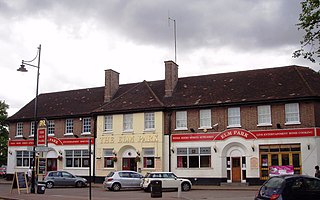
Elm Park is a suburban planned community in East London and part of the London Borough of Havering. Located 14.3 miles (23.0 km) east-northeast of Charing Cross, it is identified as a district centre in the London Plan with several streets of shops and a priority for regeneration. Prior to the construction of the extensive Elm Park Garden City development in the 1930s it was a scattered settlement of farms in the south of the parish of Hornchurch. Elm Park has been connected to central London by the electrified District line service since 1935 and the planned development of the area formed part of the interwar private housing boom that was interrupted by World War II. After the war Elm Park expanded with social housing and it has formed part of Greater London since 1965.
North Ockendon is the easternmost settlement of Greater London, England, and part of the London Borough of Havering. It is 18 miles (29 km) east-northeast of Central London and consists of a dispersed settlement within the Metropolitan Green Belt. It was historically an ancient parish in the county of Essex, which was abolished for civil purposes in 1936. North Ockendon is the only inhabited area in Greater London outside the M25 London Orbital Motorway. North Ockendon is north of South Ockendon, in Thurrock, Essex.
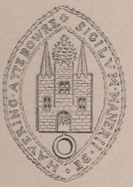
Havering, also known as Havering-atte-Bower, was a royal manor and ancient liberty whose area now forms part of, and gives its name to, the London Borough of Havering in Greater London. The manor was in the possession of the Crown from the 11th to the 19th centuries and was the location of Havering Palace from the 13th to the late 17th century. It occupied the same area as the ancient parish of Hornchurch which was divided into the three chapelries of Havering, Hornchurch and Romford.
Hornchurch was a borough constituency represented in the House of Commons of the Parliament of the United Kingdom. It elected one Member of Parliament (MP) by the first past the post system of election. At the 2010 general election parts formed the new seats of Hornchurch and Upminster; and Dagenham and Rainham.
Romford is a constituency in Greater London represented in the House of Commons of the UK Parliament since 2001 by Andrew Rosindell, a Conservative.
Hornchurch was a local government district in southwest Essex from 1926 to 1965, formed as an urban district for the civil parish of Hornchurch. It was greatly expanded in 1934 with the addition of Cranham, Great Warley, Rainham, Upminster and Wennington; and in 1936 by gaining North Ockendon. Hornchurch Urban District Council was based at Langtons House in Hornchurch from 1929. The district formed a suburb of London and with a population peaking at 131,014 in 1961, it was one of the largest districts of its type in England. It now forms the greater part of the London Borough of Havering in Greater London.
South Hornchurch is a locality to the south of Hornchurch in London Borough of Havering, east London. It is a suburban development situated 13.6 miles (21.8 km) east of Charing Cross. The area is a relatively recent addition, compared with the more mature suburbs in Havering. It was built on open farmland and the former site of RAF Hornchurch.
Hornchurch and Upminster is a constituency in Greater London represented in the House of Commons of the UK Parliament by Julia Lopez, a member of the Conservative Party, currently Minister of State for Media, Tourism and Creative Industries, who succeeded Angela Watkinson in 2017. Watkinson had been elected in 2010 as the constituency's first MP.
Romford Rural District was a local government district in southwest Essex, England from 1894 to 1934. It surrounded, but did not include, Romford which formed a separate urban district. During the life of the district the area changed in use from rural farm land to sprawling London suburb and in 1926 much of it was removed to form new urban districts.
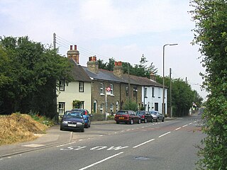
Rainham is a suburb of East London, England, in the London Borough of Havering. Historically an ancient parish in the county of Essex, Rainham is 13.6 miles (21.9 km) east of Charing Cross and is surrounded by a residential area, which has grown from the historic village, to the north and a commercial area, fronting the River Thames, to the south. As part of the suburban growth of London in the 20th century, Rainham significantly expanded and increased in population, becoming part of Hornchurch Urban District in 1934, and has formed part of Greater London since 1965. The economic history of Rainham is underpinned by a shift from agriculture to industry and manufacture and is now in a period of regeneration, coming within the London Riverside section of the Thames Gateway redevelopment area.
Havering Residents Association (HRA) is a group of residents' associations and registered political party in London, England. It is active in the London Borough of Havering and as of 2023 forms a 21-councillor group on Havering London Borough Council. At the 2022 London borough council elections they were the largest party on Havering Council, largest elected residents group in London, and the fourth largest political party represented on all London borough councils. Not all residents groups in Havering are affiliated with the HRA, usually indicating this by standing as 'independent resident' candidates. In 2014 eight members of the Havering Residents Association group split off to form the East Havering Residents Group.
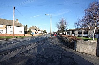
St Andrew's is an electoral ward in the London Borough of Havering. The ward has existed since the creation of the borough on 1 April 1965 and was first used in the 1964 elections. It returns three councillors to Havering London Borough Council.
The 2018 Havering London Borough Council election was held on 3 May 2018 to elect members of Havering London Borough Council in Greater London. Elections were held for all 54 seats on the council. This was on the same day as other local elections.
The 2022 Havering London Borough Council election was held on 5 May 2022 to elect all 55 members of Havering London Borough Council. The elections took place alongside local elections in the other London boroughs and elections to local authorities across the United Kingdom.