
The Droitwich Canal is a synthesis of two canals in Worcestershire, England; the Droitwich Barge Canal and the Droitwich Junction Canal. The Barge Canal is a broad canal which opened in 1771 linking Droitwich Spa to the River Severn at Hawford Bottom Lock, Claines. The Droitwich Junction Canal is a narrow canal, opened in 1854, which linked Droitwich to the Worcester and Birmingham Canal. Both were built to carry salt, and were abandoned in 1939. They have been the subject of a restoration plan since 1973, and the Barge Canal was officially reopened in 2010, while the Junction Canal reopened in July 2011. Following the opening of the canal, ownership transferred to the newly created Canal and River Trust

The King's School, Worcester is an English independent day school refounded by Henry VIII in 1541. It occupies a site adjacent to Worcester Cathedral on the banks of the River Severn in the centre of the city of Worcester. It offers mixed-sex mainstream education that follows the UK National Curriculum to around 1,465 pupils aged 2 to 18. At age 11, approximately two thirds of pupils join the senior school from its two junior schools, King's Hawford and King's St Albans, while others come from maintained schools in the city of Worcester and the surrounding areas that include Malvern, Redditch, Kidderminster, Evesham and Pershore.

Badminton House is a large country house and Grade I Listed Building in Badminton, Gloucestershire, England, and has been the principal seat of the Dukes of Beaufort since the late 17th century, when the family moved from Raglan Castle, which had been ruined in the English Civil War. The house gives its name to the sport of badminton. The gardens and park surrounding the house are Grade I on the Register of Historic Parks and Gardens.

Burrowbridge is a village and civil parish in Somerset, England, situated on the River Parrett and A361 road in the Somerset West and Taunton district, on the edge of the Somerset Levels. It is located 5 miles (8.0 km) south east of Bridgwater, and has a population of 508.

A dovecote or dovecot, doocot (Scots) or columbarium is a structure intended to house pigeons or doves. Dovecotes may be free-standing structures in a variety of shapes, or built into the end of a house or barn. They generally contain pigeonholes for the birds to nest. Pigeons and doves were an important food source historically in the Middle East and Europe and were kept for their eggs and dung.
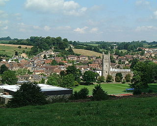
Bruton is a market town, electoral ward, and civil parish in Somerset, England, on the River Brue and the A359 between Frome and Yeovil. It is 7 miles south-east of Shepton Mallet, just south of Snakelake Hill and Coombe Hill, 10 miles north-west of Gillingham and 12 miles south-west of Frome in South Somerset district. The town and ward have a population of 2,907. The parish includes the hamlets of Wyke Champflower and Redlynch. Bruton has a museum of items from the Jurassic era onwards. It includes a table used by the author John Steinbeck on a six-month stay. The Brue is flood-prone – in 1768 it wrecked a stone bridge. The 242.8 mm of rain that fell on 28 June 1917 left a river watermark on a pub wall 20 feet above the mean. In 1984 a protective dam was built upstream.
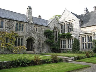
Cotehele is a medieval house with Tudor additions, situated in the parish of Calstock in the east of Cornwall, England, and now belonging to the National Trust. It is a rambling granite and slate-stone manor house on the banks of the River Tamar that has been little changed over five centuries. It was built by the Edgecumbe family in 1458 after the original Manor House was pulled down. Sir Richard Edgecumbe came into the property after fighting for Henry Tudor in the Battle of Bosworth. He was gifted with money and the original Manor House and estate and then proceeded to build Cotehele.

Antony House is the name of an early 18th-century house, which today is in the ownership of the National Trust. It is located between the town of Torpoint and the village of Antony in the county of Cornwall, England, United Kingdom. It is a Grade I listed building.

Kinwarton is a village in the valley of the River Alne, Warwickshire, to the north east of the market town of Alcester. The population of the civil parish at the 2011 census was 1,082. The ground is mostly low-lying, with a maximum altitude of 206 ft. and some of the fields near the river are liable to floods. The road from Alcester to Henley-in-Arden runs through the middle of the parish. A branch road leads off to the church and rectory about a quarter of a mile to the south and thence continues as a field-path down to a ford across the River Alne below Hoo Mill. From the north side of the main road a by-road branches off to Coughton.
Bruton Abbey in Bruton, Somerset was founded as a house of Augustinian canons in about 1127, and became an abbey in 1511, shortly before its dissolution in 1539. It was endowed with manors, churches and other properties in the area and also in Normandy in France.

Bretforton is a rural village in Worcestershire, England, 4.4 miles (7.1 km) east of Evesham, in the Vale of Evesham. It is the largest farming village near Evesham. At the 2001 census, Bretforton had a population of 1,023 in 428 households. The area of the parish is 2.83 square miles.
The Droitwich Canals Trust is an English limited company created in 1973 to work towards the restoration of the Droitwich Canal. From 2001 it worked as part of a larger group, the Droitwich Canals Restoration Partnership, and in 2004, following a successful application for a grant of £4.6 million from the Heritage Lottery Fund surrendered its lease on the canal to British Waterways, who then managed the restoration through to the reopening of the canals in 2011.
The River School is an independent Christian School, affiliated with the Christian Schools Trust. The school is located in Worcester, England, in a large, late Georgian, Grade 2 listed building, with many outbuildings, set in 8.5 acres (34,000 m2) of wooded and open grassed areas, near the A38 road in the Fernhill Heath suburb of Worcester, England.
Wichenford is a village and civil parish in the Malvern Hills District in the county of Worcestershire, England. It lies 7 miles (11km) to the north-west of the city of Worcester and has a population of c 400 for around 250 households. Primary education is provided in the nearby villages of and Hallow, and Martley which also has a secondary school.
Philip Hawford alias Ballard was the parish priest at Elmley Lovett, Worcestershire. He was also the last Abbot of Evesham and also Dean of Worcester.

Mertoun House is a country house situated by the River Tweed, 2 miles east of St Boswells in the Scottish Borders. It is home to the Duke of Sutherland. The early 18th-century house is an A listed building, and was designed by Sir William Bruce. The gardens of the house are open to the public, and are included on the Inventory of Gardens and Designed Landscapes in Scotland, the national listing of significant gardens.
Salwarpe is a small village and civil parish in the Wychavon district of Worcestershire, England, less than two miles south west of Droitwich, but in open country. The name is also spelled Salwarp, and in the time of John Leland was recorded as Salop. Since 2003, Salwarpe has shared a parish council with Hindlip and Martin Hussingtree.
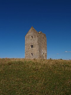
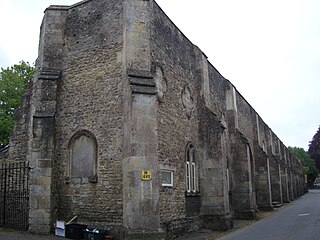
The Bruton Dovecote is a limestone tower that was built between the 15th and 17th century in Bruton in the English county of Somerset. The structure was once used as a dovecote, and may have been a watchtower or prospect tower prior to this. It is a Grade II* listed building and scheduled monument.

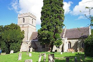
North Claines is a civil parish in Wychavon district, Worcestershire, England, immediately north of the city of Worcester. It includes the settlements of Fernhill Heath, Bevere, Lower Town, and Hawford. It is bordered to the west and north west by the River Severn and the River Salwarpe, with the Droitwich Canal running parallel to the Salwarpe.

