
Khyber Pakhtunkhwa, formerly known as North West Frontier Province, is a province of Pakistan. Located in the northwestern region of the country, Khyber Pakhtunkhwa is the fourth largest province of Pakistan by land area and the third-largest province by population. It is bordered by the Pakistani provinces of Balochistan to the south, Punjab to the south-east, the territory of Gilgit-Baltistan to the north and north-east, Islamabad Capital Territory to the east and Azad Kashmir to the north-east. It shares an international border with Afghanistan to the west. Khyber Pakhtunkhwa has a varied landscape ranging from rugged mountain ranges, valleys, plains surrounded by hills, undulating submontane areas and dense agricultural farms.

Peshawar is the sixth most populous city of Pakistan, with a population of over 4.7 million in the 2023 census. It is situated in the north-west of the country, lying in the Valley of Peshawar. It is the capital of the province of Khyber Pakhtunkhwa, where it is the largest city. Peshawar is primarily populated by Pashtuns, who comprise the second-largest ethnic group in the country. Situated in the Valley of Peshawar, a broad area situated east of the historic Khyber Pass, Peshawar's recorded history dates back to at least 539 BCE, making it one of the oldest cities in South Asia. Peshawar also remained the capital of Gandhara civilization and is among the oldest continuously inhabited cities in the country.
Dera Ismail Khan District, often abbreviated as D.I. Khan is a district in the Dera Ismail Khan division of the Khyber Pakhtunkhwa province of Pakistan. The capital of the district is the town of Dera Ismail Khan. The district has an area of 9,334 km2 (3,604 sq mi) and a population of 1,627,132 as of the 2017 Census.

Peshawar District is a district in the Peshawar Division of the Khyber Pakhtunkhwa province of Pakistan. It is located about 160 km west of the Pakistan's capital Islamabad. The district headquarter is the city of Peshawar, which is also the capital of Khyber Paktunkhwa.

Ayub Medical College is a leading public medical institute located in Abbottabad, Pakistan. It is one of the medical colleges affiliated to Khyber Medical University. AMC is the second oldest medical college of Khyber Pakhtunkhwa.

Bannu also called Bana and Bani is a city located on the Kurram River in southern Khyber Pakhtunkhwa, Pakistan. It is the capital of Bannu Division. Bannu's residents are primarily members of the Banuchi tribe and speak Banuchi (Baniswola), a dialect of Pashto which is similar to the distinct Waziristani dialect. The residents regardless of their tribes are commonly called Banusi, Banuchi or Banisi.

Khyber Teaching Hospital, also known as "Sherpao Hospital", is a university hospital and the primary teaching affiliate of Khyber Medical College.

Aftab Ahmad Khan Sherpao is a Pakistani politician who is the current chairman of the centre-left Pashtun nationalist Qaumi Watan Party, after previously being a member of the Pakistan Peoples Party. He was a member of the National Assembly of Pakistan from November 2002 to May 2018.
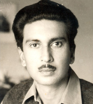
Hayat Mohammad Khan Sherpao, simply known as Hayat Sherpao, was a left-wing intellectual and socialist, serving as the 15th Governor of North West Frontier Province of Pakistan, as well as vice-chairman of Pakistan People's Party. Sherpao held important executive offices, including served as the Interior minister and had held a number of provincial ministries of the North West Frontier Province. He was assassinated in 1975, and his death was blamed on a rival political party in the province - the Awami National Party of Khan Abdul Wali Khan.
Karkhano is a market area on the western side of Peshawar, Khyber Pakhtunkhwa, Pakistan. Located in the Hayatabad suburb of the city, it is located near the Khyber District, which in turn borders Afghanistan. It is considered to be the largest business hub in Peshawar.
Landi Arbab is a village in Peshawar, Pakistan. The village is a 15-minute drive away from Peshawar International Airport and Peshawar Saddar. The village is largely populated by the Qazi, Arbab, Murad Khel, Malaks, Syed, Ahmad Zai, Fateh Khan Khel, Qasab and Ghorghust clans. It is the only village in the area that provides direct routes to Ring Road Peshawar, Peshawar City, Gulberg Peshawar, Peshawar Saddar, Peshawar Cantt, Peshawar International Airport, Kohat Road, Bara Gate, and University Road. The economy is primarily sourced from agriculture and small industries.
The Hayatabad Medical Complex is a large medical complex and hospital located in the Hayatabad suburb of Peshawar in Khyber Pakhtunkhwa, Pakistan. The second largest hospital in the city, it is a medical postgraduate training centre. The hospital provides medical and surgical specialties in the fields of Optometry, Cardiology, Paediatrics, Physiotherapy, Plastic Surgery, Psychiatry, as well as Dentistry and Dermatology. Apart from the western parts of Peshawar, the hospital also serves patients coming from surrounding regions and neighboring Afghanistan for treatment.
KMU Institute of Medical and dental Sciences, in Kohat, Khyber Pakhtunkhwa, Pakistan, is a public sector medical college, established in April 2006.
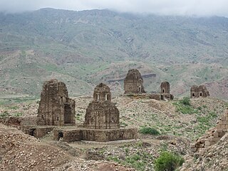
The following is a timeline of the history of the city of Peshawar, Khyber Pakhtunkhwa, Pakistan.

Government Superior Science College Peshawar is a public sector college located in Wazir Bagh Peshawar, Khyber Pakhtunkhwa, Pakistan. The college offers programs for intermediate and degree levels in Science and Arts groups. The college is affiliated for its degree programs with University of Peshawar.

Bagh-e-Naran is a recreational park located in Phase 1, Hayatabad, Peshawar, Pakistan. It is one of the largest gardens in Hayatabad, part of it is zoo. The literal meaning of "Bagh-e-Naran" in local languages is "Garden Valley". It is located close to Tatara Park.


