
Lac qui Parle County is a county in the U.S. state of Minnesota. As of the 2020 census, the population was 6,719. Its county seat is Madison. The largest city in the county is Dawson.
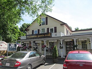
Williamsburg is a town in Hampshire County, Massachusetts, United States. The population was 2,504 at the 2020 census. It is part of the Springfield, Massachusetts Metropolitan Statistical Area.
Rollins is an unincorporated community in Ault Township, Saint Louis County, Minnesota, United States.
Collegeville is an unincorporated community in St. Wendel Township, Stearns County, Minnesota, United States, near St. Joseph. The community is located near the junction of Collegeville Road and Old Collegeville Road. Nearby is Saint John's Abbey, a large Benedictine monastery.

Minnesota Glacier is a broad glacier, about 40 nautical miles long and 5 nautical miles wide, flowing east through the Ellsworth Mountains in Antarctica, separating the Sentinel Range and the Heritage Range. It is nourished by ice from the plateau west of the mountains and by Nimitz Glacier and Splettstoesser Glacier, and merges into the larger Rutford Ice Stream at the eastern margin of the Ellsworth Mountains.

Green Township is one of the eleven townships of Hocking County, Ohio, United States. As of the 2020 census the population was 3,224.

Haydenville is an unincorporated community and census-designated place (CDP) in southern Green Township, Hocking County, Ohio, United States. As of the 2020 census the population of the CDP was 337.
Kelsey is an unincorporated community in Kelsey Township, Saint Louis County, Minnesota, United States.
Peary is an unincorporated community in Saint Louis County, Minnesota, United States.
Payne is an unincorporated community in Meadowlands Township, Saint Louis County, Minnesota, United States.
Burnett is an unincorporated community in Industrial Township, Saint Louis County, Minnesota, United States.
Keenan is an unincorporated community in Clinton Township, Saint Louis County, Minnesota, United States.
Peyla is an unincorporated community in Vermilion Lake Township, Saint Louis County, Minnesota, United States.
Robinson is an unincorporated community in Morse Township, Saint Louis County, Minnesota, United States.
Soudan is an unincorporated community and census-designated place (CDP) in Breitung Township, Saint Louis County, Minnesota, United States. As of the 2010 census, its population was 446.
Exum Glacier is a small glacier flowing north between Hughes Point and Bonnabeau Dome, in the Jones Mountains of Antarctica. It was mapped by the University of Minnesota – Jones Mountains Party, 1960–61, and was named by the party for Glenn Exum, a mountaineer who provided training in rock and ice climbing for the University of Minnesota field parties of 1960–61 and 1961–62.
Gopher Glacier is a glacier descending from Christoffersen Heights and draining north between Bonnabeau Dome and Anderson Dome, in the Jones Mountains of Antarctica. It was mapped and named by the University of Minnesota Jones Mountains Party, 1960–61; "Gopher" is the nickname of the University of Minnesota and of the State.

Bear Valley is a census-designated place in Mariposa County, California, United States. It is located 10.5 miles (16.9 km) south-southeast of Coulterville, at an elevation of 2,054 feet (626 m). Bear Valley has been designated California Historical Landmark #331. The population was 156 at the 2020 census.
Haydenville may refer to:
Wahlsten is an unincorporated community in Kugler Township, Saint Louis County, Minnesota, United States.


