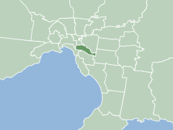
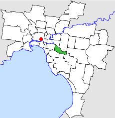
The City of Stonnington is a local government area located within the metropolitan area of Melbourne, Australia. It comprises the inner south-eastern suburbs, between 3 and 13 km, from the Melbourne CBD. The city covers an area of 25.7 km2 (9.9 sq mi).

Glen Iris is a suburb in Melbourne, Victoria, Australia, 10 kilometres (6.2 mi) south-east of Melbourne's Central Business District, located within the Cities of Boroondara and Stonnington local government areas. Glen Iris recorded a population of 26,131 at the 2021 census.
Armadale is an inner suburb in Melbourne, Victoria, Australia, 7 km south-east of Melbourne's Central Business District, located within the City of Stonnington local government area. Armadale recorded a population of 9,368 at the 2021 census.

Kooyong is a suburb in Melbourne, Victoria, Australia, 7 km south-east of Melbourne's Central Business District, located within the City of Stonnington local government area. Kooyong recorded a population of 842 at the 2021 census.

Malvern is a suburb of Melbourne, Victoria, Australia, 8 km south-east of Melbourne's Central Business District, located within the City of Stonnington local government area. Malvern recorded a population of 9,929 at the 2021 census.
Malvern East is a suburb in Melbourne, Victoria, Australia, 13 km south-east of Melbourne's Central Business District, located within the City of Stonnington local government area. Malvern East recorded a population of 22,296 at the 2021 census.
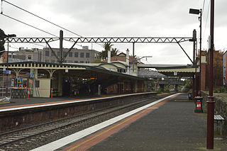
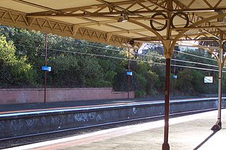
Malvern railway station is a commuter railway station on the southern border of Malvern, a suburb of Melbourne, Victoria, Australia. The station is listed on the Victorian Heritage Register and was opened on 7 May 1879. The station consists of an island platform and two side platforms all accessed by a pedestrian bridge. There are two principal station buildings located on the central platform and on platform 4, consisting of a small two and one-story brick buildings. These buildings were provided in 1914, as ticketing and staff offices. The station is only partially accessible due to a multiple steep access ramps.

Melbourne is Australia's second largest city and widely considered to be a garden city, with Victoria being nicknamed "the Garden State". Renowned as one of the most livable cities in the world, there is an abundance of parks, gardens and green belts close to the CBD with a variety of common and rare plant species amid landscaped vistas, pedestrian pathways, and tree-lined avenues, all managed by Parks Victoria.

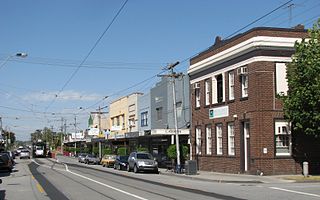
Glenferrie Road is a major north–south thoroughfare in Melbourne, Australia. It runs from Kew to Caulfield North, and includes major shopping districts at both Hawthorn and Malvern. There are a number of rail transport options on Glenferrie Road and also some landmarks.

The Gardiners Creek Trail is a shared use path for cyclists and pedestrians, which follows Gardiners Creek through the eastern suburbs of Melbourne, Victoria, Australia.
Waverley Road was a station on the Outer Circle railway line, opened on 3 March 1890 as "Waverley" on the section between Burnley and Oakleigh stations, and was renamed on 23 June 1890. It became a junction on 30 May 1890 when the line from Camberwell opened, and was a Staff and Ticket station, being provided with a signal box of 28 levers. Two platforms were provided, with the junction of the two lines at the North (Camberwell) end, as was a goods siding located near the current East Malvern station in Malvern East, Victoria, Australia, in what is now the Malvern Urban Forest. The platform, the mound of which can still be seen, was located approximately 120 metres SSE of where the line crossed Waverley Road.
Malvern Town Hall is the former town hall of the municipality of Malvern in the state of Victoria, Australia. It is the seat of the local government area of the City of Stonnington.
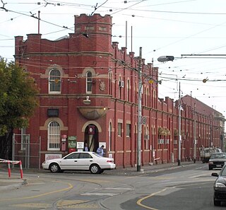
Malvern tram depot is located in Coldblo Road, Armadale, Victoria, a suburb of Stonnington, Australia. Operated by Yarra Trams, it is one of eight tram depots on the Melbourne tram network.

Prahran Town Hall is a civic building located on the corner of Chapel Street and Greville Street in Prahran, a suburb of Melbourne, Australia.

The Scotchmans Creek Trail is a shared use path for cyclists and pedestrians, which follows Scotchmans Creek through the eastern suburbs of Melbourne, Victoria, Australia.
Neighbourhood character refers to the 'look and feel of an area', in particular a residential area. It also includes the activities that occur there. In everyday usage, it can often be synonymous with local character, residential character, urban character and place identity, but those terms can have more specific meanings in connection with urban planning and conservation.

Stonington is a private residence and former Australian Government House located in the Melbourne suburb of Malvern, at 336 Glenferrie Road. The house was built for John Wagner, a partner in Cobb and Co coaches. Stonington gave its name to the City of Stonnington, a Melbourne municipality.
The City of Malvern was a local government area about 9 kilometres (6 mi) southeast of Melbourne, the state capital of Victoria, Australia. The city covered an area of 15.88 square kilometres (6.13 sq mi), and existed from 1856 until 1994, when it was merged with the City of Prahran to create the City of Stonnington.

The City of Prahran was a local government area about 5 kilometres (3 mi) southeast of Melbourne, the state capital of Victoria, Australia. The city covered an area of 9.55 square kilometres (3.69 sq mi), and existed from 1855 until 1994, when it was merged with the City of Malvern to create the City of Stonnington.

The Harold Holt Memorial Swimming Centre is a public swimming pool complex located on the corner of High Street and Edgar Street, Glen Iris, Melbourne, Australia. Built in the 1960s by Australian architects Kevin Borland and Daryl Jackson, the Swimming Centre is considered to be a fine example of Brutalist architecture. Originally built as a municipal swimming baths, in 1927, the facilities were renovated in 1967 by Borland and Jackson to accommodate for higher swimming participation numbers. It is named in honour of Prime Minister Harold Holt, whose apparent drowning death was announced during its construction and who was the local member of parliament.

