Hemingway, South Carolina

Last updated

Hemingway, South Carolina
HemingwayWaterTower.jpg
Water tower in downtown Hemingway
SCMap-doton-Hemingway.PNG
Location of Hemingway, South Carolina
Coordinates: 33°45′12″N79°26′45″W / 33.75333°N 79.44583°W / 33.75333; -79.44583
Country United States
State South Carolina
County Williamsburg County, South Carolina
Area
[1]
  Total0.86 sq mi (2.24 km2)
  Land0.86 sq mi (2.24 km2)
  Water0.00 sq mi (0.00 km2)
Elevation
52 ft (16 m)
Population
 (2020) [2]
  Total504
  Density583.33/sq mi (225.28/km2)
Time zone UTC-5 (Eastern (EST))
  Summer (DST) UTC-4 (EDT)
ZIP code
29554
Area code(s) 843, 854
FIPS code 45-33145 [3]
GNIS feature ID1245951 [4]
Website www.townofhemingway.org

Hemingway is a town in Williamsburg County, South Carolina, United States. The population was 459 at the 2010 census.

Contents

History

Hemingway was created from a crossroads community named Lamberts in 1911 by Dr. W. C. Hemingway, in an effort to secure a depot for the proposed Seaboard Coast Line Railroad, which was to run from Mullins to Andrews. Land owned by Dr. Hemingway was surveyed and the lots auctioned off. Subsequently, the railroad established a Hemingway depot, and the post office name was changed to Hemingway.

With rail access, Hemingway grew into a market town for local agricultural products. Cotton declined after 1921, when the boll weevil arrived, but was already being replaced by flue-cured tobacco as the primary money crop for farmers. Other local products were naval stores from the pine forests (later replaced by timbering), corn, soybeans, wheat, and vegetables.

Hemingway is near the Pee Dee River, which was the main commercial route for the area until the coming of the railroad. Snows Lake is near Hemingway. This is also a site in the Revolutionary War camp of US war hero General Francis Marion. The river was named by early explorers after the Pee Dee tribe. A major tributary is the Waccamaw River, likewise named.

Pleasant Hill Consolidated School was listed on the National Register of Historic Places in 1998. [5]

Geography

According to the United States Census Bureau, the town has a total area of 0.9 square miles (2.3 km2), all of it land.

Demographics

Historical population
CensusPop.Note
1920 371
1930 351−5.4%
1940 53652.7%
1950 82153.2%
1960 95115.8%
1970 1,0267.9%
1980 853−16.9%
1990 829−2.8%
2000 573−30.9%
2010 459−19.9%
2020 5049.8%
U.S. Decennial Census [6] [2]

As of the census [3] of 2000, 573 people, 259 households, and 182 families resided in the town. The population density was 653.2 inhabitants per square mile (252.2/km2). The 278 housing units averaged 316.9 per square mile (122.0/km2). The racial makeup of the town was 80.80% White, 18.50% African American, 0.35% Native American, 0.17% from other races, and 0.17% from two or more races. Hispanics or Latinos of any race were 0.17% of the population. Of the 259 households, 26.3% had children under the age of 18 living with them, 49.4% were married couples living together, 15.8% had a female householder with no husband present, and 29.7% were not families. About 29.3% of all households were made up of individuals, and 15.4% had someone living alone who was 65 years of age or older. The average household size was 2.21 and the average family size was 2.71.

In the town, the population was distributed as 22.3% under the age of 18, 5.9% from 18 to 24, 21.3% from 25 to 44, 26.7% from 45 to 64, and 23.7% who were 65 years of age or older. The median age was 45 years. For every 100 females, there were 82.5 males. For every 100 females age 18 and over, there were 75.2 males.

The median income for a household in the town was $28,250, and for a family was $50,179. Males had a median income of $28,125 versus $20,987 for females. The per capita income for the town was $17,888. About 9.9% of families and 13.1% of the population were below the poverty line, including 18.2% of those under age 18 and 15.6% of those age 65 or over.

Economy

Besides agriculture, the manufacture of textiles has been important in the past, with numerous sewing factories, but most of these have closed. Talous, where insect-resistant suits for sportsmen are sewed, and Hemingway Apparel, are exceptions. Important industries today are Tupperware (plastic kitchenware), House of Raeford (meat products), C-V Unlimited (remanufactured auto parts), Don's Scrap Iron and Metal Co., Southeastern Wire Fabricators, Inc. (manufactured wire products), and Palmetto Paper Tube. Some people commute to Wellman Industries in Johnsonville, South Carolina or to International Paper Company or Georgetown Steel in Georgetown. Williamsburg County runs a bus service for workers who commute to nearby Myrtle Beach, which offers jobs in the hospitality industry and construction.

Hemingway has always been associated with Johnsonville, which, though divided by a county line, is only 4 miles north, and they are sometimes referred to locally as the twin cities. Hemingway recently completed a new industrial park midway between the two cities, with a deep well and sewer service.

Arts and culture

Hemingway hosts the annual Bar-B-Q Shag Festival held in the spring. This features a cookoff of low country-style pork barbecue, and dancing of the official state dance of South Carolina - the Carolina shag.

Hemingway has a public library, a branch of the Williamsburg County Library. [7]

Notable people

Related Research Articles

<span class="mw-page-title-main">Williamsburg County, South Carolina</span> County in South Carolina, United States

Williamsburg County is a county located in the U.S. state of South Carolina. As of the 2020 census its population was 31,026. The county seat and largest community is Kingstree. After a previous incarnation of Williamsburg County, the current county was created in 1804.

<span class="mw-page-title-main">Marlboro County, South Carolina</span> County in South Carolina, United States

Marlboro County is a county located in the Pee Dee region on the northern border of the U.S. state of South Carolina. As of the 2020 census, its population was 26,667. Its county seat is Bennettsville. The Great Pee Dee River runs through it.

<span class="mw-page-title-main">Marion County, South Carolina</span> County in South Carolina, United States

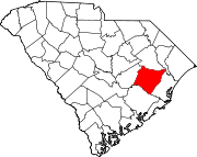
Marion County is a county located in the coastal plain of the U.S. state of South Carolina. As of the 2020 census, its population was 29,183. Its county seat is Marion. It is a majority-minority county.

<span class="mw-page-title-main">Georgetown County, South Carolina</span> County in South Carolina, United States

Georgetown County is a county located in the U.S. state of South Carolina. As of the 2020 census, the population was 63,404. Its county seat is Georgetown. The county was founded in 1769. It is named for George III of the United Kingdom.

<span class="mw-page-title-main">Florence County, South Carolina</span> County in South Carolina, United States

Florence County is a county located in the U.S. state of South Carolina. As of the 2020 census, its population was 137,059. Its county seat is Florence.

<span class="mw-page-title-main">Dillon County, South Carolina</span> County in South Carolina, United States

Dillon County is a county located in the U.S. state of South Carolina. As of the 2020 census, the county's population was 28,292. The county seat is Dillon.

<span class="mw-page-title-main">Williamsburg, Iowa</span> City in Iowa, United States

Williamsburg is a city in Iowa County, Iowa, United States. The population was 3,346 at the time of the 2020 census. Williamsburg is known for Holden's Foundation Seeds, a foundation seed corn company, and Kinze Manufacturing, Inc., a farm implement manufacturer. Aviation pioneer Eugene Ely was born outside Williamsburg.

<span class="mw-page-title-main">Norwood, North Carolina</span> Town in North Carolina, United States

Norwood is a town in Stanly County, North Carolina, United States. The population was 2,379 at the 2010 census.

<span class="mw-page-title-main">Byars, Oklahoma</span> Town in Oklahoma, United States

Byars is a town in McClain County, Oklahoma, United States. The population was 184 at the 2020 census, down from 255 at the 2010 census.

<span class="mw-page-title-main">Wagener, South Carolina</span> Town in South Carolina

Wagener is a town in Aiken County, South Carolina, United States. The population was 797 at the 2010 census, making it the largest settlement in the county north of the South Fork Edisto River. It is part of the Augusta, Georgia metropolitan area.

<span class="mw-page-title-main">Society Hill, South Carolina</span> Town in South Carolina, United States

Society Hill is a town in Darlington County, South Carolina, United States alongside the Pee Dee River. It is the oldest community in Darlington County and one of the first towns founded in South Carolina. The town was once the intellectual center of the Pee Dee region. However, the town's fortunes declined in the 19th century after rivers became less important as means of transportation. It is part of the Florence Metropolitan Statistical Area.

<span class="mw-page-title-main">Johnsonville, South Carolina</span> City in South Carolina, United States

Johnsonville is a city in Florence County, South Carolina, United States. The population was 1,480 at the 2010 census. It is part of the Florence Metropolitan Statistical Area.

<span class="mw-page-title-main">Lake City, South Carolina</span> City in South Carolina, United States

Lake City is a city in Florence County, South Carolina, United States. The population was 6,675 at the 2010 census. Located in central South Carolina, it is south of Florence and included as part of the Florence Metropolitan Statistical Area.

<span class="mw-page-title-main">Conway, South Carolina</span> City in South Carolina, United States

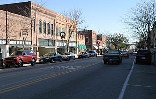
Conway is a city and the county seat of Horry County, South Carolina, United States. The population was 24,849 at the 2020 census, up from 17,103 in the 2010 census, making it the 18th-most populous city in the state. The city is part of the Myrtle Beach metropolitan area. It is the home of Coastal Carolina University.

<span class="mw-page-title-main">Bethune, South Carolina</span> Town in South Carolina, United States

Bethune is a small town in Kershaw County, South Carolina, United States. The population was 334 at the 2010 census. It is part of the Columbia, South Carolina Metropolitan Statistical Area.

<span class="mw-page-title-main">Marion, South Carolina</span> City in South Carolina, United States

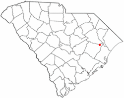
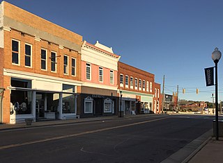
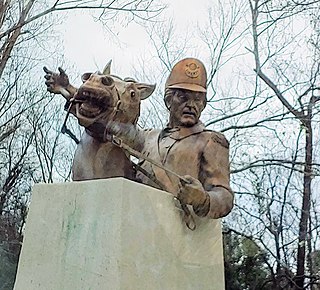
Marion is a city in and the county seat of Marion County, South Carolina, United States. It is named for Francis Marion, a brigadier general from South Carolina in the American Revolutionary War. The population was 6,939 at the 2010 census.

<span class="mw-page-title-main">McColl, South Carolina</span> Town in South Carolina, United States

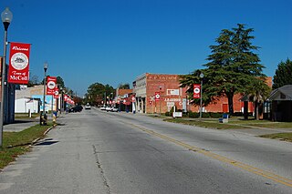
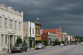
McColl is a town in Marlboro County, South Carolina, United States. It lies in the state's Pee Dee region, 8 miles (13 km) from the North Carolina border. The population was 2,174 at the 2010 census.

<span class="mw-page-title-main">Lane, South Carolina</span> Town in South Carolina, United States

Lane is a town in Williamsburg County, South Carolina, United States. The population was 480 at the 2020 census.

<span class="mw-page-title-main">New Johnsonville, Tennessee</span> City in Tennessee, United States

New Johnsonville is a city in Humphreys County, Tennessee, United States. The population was 1,951 at the 2010 census.

<span class="mw-page-title-main">Andrews, South Carolina</span> Town in South Carolina, United States

Andrews is a town in both Georgetown and Williamsburg counties in the U.S. state of South Carolina. Its total population was 2,861 at the 2010 census, down from 3,068 in 2000. General aviation airfield Robert F. Swinnie Airport is 2 miles (3 km) east of its central business district.

References

  1. "ArcGIS REST Services Directory". United States Census Bureau. Retrieved October 15, 2022.
  2. 1 2 "Census Population API". United States Census Bureau. Retrieved October 15, 2022.
  3. 1 2 "U.S. Census website". United States Census Bureau . Retrieved January 31, 2008.
  4. "US Board on Geographic Names". United States Geological Survey. October 25, 2007. Retrieved January 31, 2008.
  5. "National Register Information System". National Register of Historic Places . National Park Service. July 9, 2010.
  6. "Census of Population and Housing". Census.gov. Retrieved June 4, 2015.
  7. "Homepage". Carvers Bay Library. Retrieved June 8, 2019.
  8. "Rodneys" . Retrieved January 19, 2023.
  9. Why The Best Southern Barbecue Takes Weeks To Make — Southern Foodways Alliance , retrieved January 19, 2023
  10. "8 Bizarre Food Jobs That You May Want". Spoon University. March 22, 2017. Retrieved March 29, 2022.