Henderskelfe

Last updated

Henderskelfe
Civil parish
Centenary Way footpath - geograph.org.uk - 3635892.jpg
Centenary Way footpath in Henderskelfe parish
North Yorkshire UK location map (2023).svg
Red pog.svg
Henderskelfe
Location within North Yorkshire
Population50 (2015) NYCC [1]
OS grid reference SE719700
Unitary authority
Ceremonial county
Region
Country England
Sovereign state United Kingdom
Post town YORK
Postcode district YO60
Police North Yorkshire
Fire North Yorkshire
Ambulance Yorkshire
UK Parliament
List of places
UK
England
Yorkshire
54°07′19″N0°54′43″W / 54.122°N 0.912°W / 54.122; -0.912

Henderskelfe is a civil parish in North Yorkshire, England. The parish does not contain any villages, though it is named after a previous settlement and castle which occupied the land on which Castle Howard is now built. Historically the area was a township in the ecclesiastical parish of Bulmer, however it has been its own civil parish since 1866.

Contents

History

Originally, the area had been called Hinderskelfe, and the manor lands of Hinderskelfe stretched between Stamford Bridge, what is now Castle Howard and Lastingham. [2] Mentioned in the Domesday Book, the area was home to a village and a church, both now lost, with Castle Howard being built on top of the village, and Henderskelfe/Hinderskelfe Castle. [3] As the church had been destroyed, no clergy were assigned to the area, and it became known as an extra-parochial area. [4] The site of the rectory and the church now lie underneath the South Lake, and the garden respectively on the Castle Howard estate. In 1846, a private bill was passed in the House of Commons and the House of Lords, which effectively swapped the two parcels of land in Henderskelfe, with land in Sheriff Hutton; the Archbishop of York owned the parcel of land beneath the lake, and no longer needed it. [5] The township of Henderskelfe remained in the ecclesiastical parish of Bulmer for marriages births and baptisms after it had been created as a civil parish. [6]

Henderskelfe Castle was built during the reign of Edward III to a quadrangular design, though it was listed as being in ruins by 1359. [7]

Foundations of a 16th century house, Henderskelfe 16th century house, Henderskelfe (rubble foundation).png
Foundations of a 16th century house, Henderskelfe

Leland states in Collectanea, that in 1070, a Scottish raiding party under King Malcolm, "...came to a place called Hinderskelfe and slew some English nobility." [8] At the time of the Domesday survey, the land belonged to Berengar of Tosny, who died without issue and so it passed to his sister, Adeliza, who married Roger Bigod. Henderskelfe passed to the monarchy in 1306, when Bigod died, and all his honours were transferred to the crown. [9] The manor was owned by the Greystoke family in the 16th and 17th centuries. [10] Henderskelfe Castle and village were rebuilt in 1683, but destroyed by fire in 1693. The building of Castle Howard started c.1699, and some of the external walls by the gate were built from stone sourced from the ruined castle. [11] [12] Henderskelfe Castle and village were both located immediately west of Ray Wood, which still exists today. A map of 1694, drawn a year after fire destroyed the castle, shows the layout of the village and castle. [13]

The name of Henderskelfe has been suggested by Smith to be an Old Norse combination of Hildar and skjálf; a female personal name and either shelf or seat. [14] However, Morris suggests the name stems from Hundred-Hill, as the site was the meeting place of the wapentakes of Ryedale and Bulmer. [15] The remains of the village of Hinderskelfe/Henderskelfe were demolished when the current Castle Howard buildings were erected in 1699. A map of 1690 shows 24 houses present, though no document records what happened to the villagers. Beresford suggested that the villagers were given houses in either Coneysthorpe or Welburn. [16] The area was classified as a township until 1866, when it was redesignated as a civil parish. [17] Previous to this, the township of Henderskelfe was in the parish of Bulmer, and consisted of 1,500 acres (610 ha), most of which was given over to the Castle Howard estate. [18] By 1872, the parish area was defined as being 1,620 acres (660 ha), [17] which had grown to 1,705 acres (690 ha) by 1890. [19]

In 1987, the whole of the parish became part of the newly created Howardian Hills Area of Outstanding Natural Beauty. [20] The Centenary Way long-distance footpath crosses the eastern side of the parish. [21] [22]

Governance

Henderskelfe was historically in the wapentake of Bulmer, and part of the Malton Rural District in the North Riding of Yorkshire. It is now in the shire district of Ryedale in North Yorkshire. [23] The parish forms part of the Thirsk and Malton Constituency for national government purposes. [24]

In the 2001 census, the parish details were listed as being "below the Office for National Statistics threshold data" (the population was less than 100), so the details were contained within the adjacent parish of Coneysthorpe. [25]

Population of Henderskelfe 1801–2015
18011811182118311841185118611871188118911901191119211931195119611971200120112015
137 [26] 137 [26] 159 [26] 150 [26] 157 [26] 148 [26] 157 [26] 162 [26] 132 [26] 108 [26] 99 [26] 100 [17] 72 [17] 89 [17] 85 [17] 94 [17] 65 [27] N/A [note 1] 60 [note 2] 50 [note 3]

Notable residents

Notes

  1. The population of Henderskelfe was included with that of the neighbouring parish of Coneysthorpe
  2. Estimated population. [1]
  3. Estimated population. [1]

Related Research Articles

<span class="mw-page-title-main">Castle Howard</span> Stately home in North Yorkshire, England

Castle Howard is a stately home in North Yorkshire, England, within the civil parish of Henderskelfe, located 15 miles (24 km) north of York. It is a private residence and has been the home of the Carlisle branch of the Howard family for more than 300 years. Castle Howard is not a fortified structure, but the term "castle" is sometimes used in the name of an English country house that was built on the site of a former castle.

<span class="mw-page-title-main">Welburn-on-Derwent</span> Village and civil parish in North Yorkshire, England

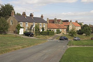
Welburn is a village and civil parish in North Yorkshire, England, on the north bank of the River Derwent. It lies on the edge of the Howardian Hills, near to the stately home Castle Howard. It is about 14 miles from York and 5 miles south-west of Malton/Norton. It is a popular area for walkers and bird-watchers. The parish's population was estimated at 523 people in 2013. This figure includes the developments at Crambeck, Holmes Crescent and Chestnut Avenue that are some distance outside the heart of the village.

<span class="mw-page-title-main">Bulmer, North Yorkshire</span> Village and civil parish in North Yorkshire, England

Bulmer is a village and civil parish in North Yorkshire, England. According to the 2001 census it had a population of 174, increasing to 202 at the census 2011. The village is about 7 miles (11 km) south-west of Malton.

<span class="mw-page-title-main">Gate Helmsley</span> Village and civil parish in North Yorkshire, England

Gate Helmsley is a village and civil parish in North Yorkshire, England, about seven miles east of York. The village lies on the border with the East Riding of Yorkshire.

<span class="mw-page-title-main">Holtby</span> Village and civil parish in North Yorkshire, England

Holtby is a small village and civil parish in the unitary authority of the City of York in North Yorkshire, England. The population at the 2011 Census was 166. It lies close to the A166 about 5 miles (8 km) east of York.

<span class="mw-page-title-main">Whenby</span> Village and civil parish in North Yorkshire, England

Whenby is a civil parish and village in North Yorkshire, England. The village and parish is largely agricultural in nature, and although the village has a parish church. it was declared redundant in 1983. It is now maintained by the Churches Conservation Trust.

<span class="mw-page-title-main">Gilling East</span> Village and civil parish in North Yorkshire, England

Gilling East is a village and civil parish in North Yorkshire, England, on the main B1363 road between York and Helmsley, 2 miles (3.2 km) south of Oswaldkirk and 5 miles (8 km) south of Helmsley. It is named "East" to distinguish it from Gilling West near Richmond, some 32 miles (51 km) away. It had a population of 321 at the 2001 Census, which had risen to 345 at the 2011 census. In 2015, North Yorkshire County Council estimated the population to be 360. The village lies in the Howardian Hills just south of the North York Moors National Park and close to Ampleforth Abbey and College.

<span class="mw-page-title-main">Crambe, North Yorkshire</span> Village and civil parish in North Yorkshire, England

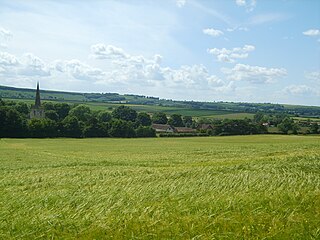
Crambe is a village and civil parish in the Ryedale district of North Yorkshire, England. It is near the River Derwent and 6 miles (10 km) south-west of Malton. The population as of the 2011 census was less than 100. Details are included in the civil parish of Whitwell-on-the-Hill. The village is located in the Howardian Hills Area of Outstanding Natural Beauty. The father of the renowned mathematician Karl Pearson was born in the village.

<span class="mw-page-title-main">Terrington</span> Village and civil parish in North Yorkshire, England

Terrington is a village and civil parish in the Ryedale district of North Yorkshire, England. It is situated in the Howardian Hills, 4 miles (6.4 km) west of Malton.

<span class="mw-page-title-main">Stonegrave</span> Village and civil parish in North Yorkshire, England

Stonegrave is a village and civil parish in North Yorkshire, England. At the 2011 Census the population was less than 100 and so the details are included in the civil parish of Nunnington. By 2015, North Yorkshire County Council estimated the population as 110. It is situated in the Howardian Hills Area of Outstanding Natural Beauty (AONB) and 5 miles (8 km) south east of Helmsley on the Helmsley to Malton road.

<span class="mw-page-title-main">Scackleton</span> Village and civil parish in North Yorkshire, England

Scackleton is a village and civil parish in the Ryedale district of North Yorkshire, England. It is in the Howardian Hills and 2 miles (3.2 km) south-west of Hovingham.

<span class="mw-page-title-main">Hovingham</span> Village and civil parish in North Yorkshire, England

Hovingham is a large village and civil parish in the Ryedale district of North Yorkshire, England. It is on the edge of the Howardian Hills and about 7 miles (11 km) south of Kirkbymoorside.

<span class="mw-page-title-main">Wintringham, North Yorkshire</span> Village and civil parish in North Yorkshire, England

Wintringham is a village and civil parish in North Yorkshire, England. The village is near the A64 road and 6 miles (9.7 km) east of Malton.

<span class="mw-page-title-main">Butterwick, Foxholes</span> Village in North Yorkshire, England

Butterwick is a village and former civil parish, now in the parish of Foxholes (1.75 miles to the east, near the village of Weaverthorpe, in North Yorkshire, England. The village lies in the Great Wold Valley and the course of the winterbourne stream the Gypsey Race passes through it. Until 1974 the village lay in the historic county boundaries of the East Riding of Yorkshire. From 1974 to 2023 it was part of the Ryedale district.

Swinton is a village and civil parish in North Yorkshire, England. It is about 2 miles (3.2 km) west of Malton on the B1257 road, and is on the edge of the Howardian Hills AONB to the immediate north. The village appears in the Domesday Book as 'Swintune' which is derived from 'pig farm'.

<span class="mw-page-title-main">Argam</span> Former parish in the East Riding of Yorkshire, England

Argam, or Argham, was a civil parish and village in the East Riding of Yorkshire, England. The site is listed in many historical documents, but was deserted by the early 19th century, now being part of the civil parish of Grindale. The village was depopulated, becoming one of the known deserted Medieval villages in Yorkshire.

<span class="mw-page-title-main">Lillings Ambo</span> Civil parish in North Yorkshire, England

Lillings Ambo is a civil parish in North Yorkshire, England. It is between the villages of Strensall and Sheriff Hutton, and its southern edge is the border between the unitary authorities of North Yorkshire Council and the City of York Council. The River Foss flows through the parish, and in 2020, a scheme was approved to build a leaky dam to store water in the south of the parish in times of flood.

<span class="mw-page-title-main">Marishes</span> Civil parish in North Yorkshire, England

Marishes is a civil parish in North Yorkshire, England. The parish has an area of some 2,960 acres, and is located between Malton and Pickering in the low-lying Vale of Pickering. Whilst the main occupation of the residents in the parish is agricultural in nature, the area is known for its onshore gas field. In 2015, the population of the parish was estimated to be 140.

<span class="mw-page-title-main">Henderskelfe Castle</span> Ruined castle in England

Henderskelfe Castle, or Henderskelf Castle in older texts, was a Medieval castle in the English county of North Yorkshire. It stood on what is now the site of Castle Howard, a large stately home.

<span class="mw-page-title-main">Saxton with Scarthingwell</span> Civil parish in North Yorkshire, England

Saxton with Scarthingwell is a civil parish just south of Tadcaster in North Yorkshire, England. The parish contains the villages of Saxton and Scarthingwell, with two churches and the remains of a castle. Historically the area was a township, however it has been its own civil parish since 1866. Although the main part of the Battle of Towton was fought to the north out of the parish, some of the dead were interred in the parish, and at least one minor skirmish was fought within the parish boundaries.

References

  1. 1 2 3 "2015 Population Estimates Parishes" (PDF). northyorks.gov.uk. December 2016. p. 16. Archived from the original (PDF) on 4 June 2022. Retrieved 25 March 2023.
  2. 1 2 "A majestic gem rises from the ruins". Gazette & Herald. 6 May 2009. Retrieved 27 September 2022.
  3. "Henderskelfe | Domesday Book". opendomesday.org. Retrieved 27 September 2022.
  4. "Genuki: Extraparochial, Yorkshire (North Riding)". www.genuki.org.uk. Retrieved 27 September 2022.
  5. Beresford 1952, pp. 284–285.
  6. Wilson, Ellen (1995). The parish register of Bulmer, 1571-1837. Leeds: Privately printed for the Parish Register Section. p. xi. ISBN   0902122703.
  7. "Henderskelfe Castle". www.heritagegateway.org.uk. Retrieved 30 September 2022.
  8. Whellan, T. (1859). History and Topography of the City of York, and the North Riding of Yorkshire: embracing a general review of the early history of Great Britain, and a general history and description of the County of York, Volume 2. Beverley: John Green. p. 581. OCLC   74378767.
  9. Scurfield, C (2011). "A Proposed Caravan Club Site At Park Farm, The Castle Howard Estate, North Yorkshire: An Archaeological Desk-Based Assessment". CS Archaeology Series: 15. doi:10.5284/1017260.
  10. Dockray, Keith (23 September 2004). "Greystoke family". Oxford Dictionary of National Biography (online ed.). Oxford University Press. doi:10.1093/ref:odnb/54524.(Subscription or UK public library membership required.)
  11. Pevsner, Nikolaus, Sir (2002). Yorkshire, the North Riding. New Haven: Yale University Press. p. 107. ISBN   0300096658.{{cite book}}: CS1 maint: multiple names: authors list (link)
  12. Levine 2009, p. 337.
  13. Levine 2009, p. 331.
  14. Smith, A. H. (1979) [1928]. The Place Names of the North Riding of Yorkshire. English Place Name Society. p. 40. OCLC   19714705.
  15. Morris, Frances Orpen (1881). The county seats of the noblemen and gentlemen of Great Britain and Ireland. London: Longman Green & Co. p. 11.
  16. Beresford 1952, p. 286.
  17. 1 2 3 4 5 6 7 "Henderskelf CP/Tn". visionofbritain.org.uk. Retrieved 28 September 2022.
  18. Page 1968, p. 107.
  19. Bulmer 1890, p. 656.
  20. The Howardian hills, proposed area of outstanding natural beauty: Statement of intent by the local planning authorities. North Yorkshire: Ryedale District Council. 1984. p. 15. OCLC   59345684.
  21. Rushby, Kevin (1 March 2013). "Unsung Britain: Walking North Yorkshire's Howardian Hills". The Guardian. Retrieved 28 September 2022.
  22. Somerville, Christopher (5 January 2019). "A good walk: Howardian Hills, North Yorkshire" . The Times. Retrieved 28 September 2022.
  23. North Yorkshire gazetteer of townships and parishes. Northallerton: North Yorkshire County Council. 1991 [1986]. p. 16. ISBN   0-906035-29-5.
  24. "Election Maps - Henderskelfe". www.ordnancesurvey.co.uk. Retrieved 28 September 2022.
  25. "2011 Census Profiles for Ryedale Civil Parishes" (PDF). datanorthyorkshire.org. Retrieved 27 September 2022.
  26. 1 2 3 4 5 6 7 8 9 10 11 Page, William, ed. (1907). The Victoria history of the county of York. vol 3. London: Constable & Co. p. 507. OCLC   500092527.
  27. Census 1971, England and Wales, county report / Yorkshire, North Riding. Part 1. London: H.M.S.O. 1974 [1973]. p. 8. ISBN   0-11-690379-1.
  28. Ellis, Steven G. (23 September 2004). "Dacre, William, third Baron Dacre of Gilsland and seventh Baron Greystoke". Oxford Dictionary of National Biography (online ed.). Oxford University Press. doi:10.1093/ref:odnb/46514.(Subscription or UK public library membership required.)
  29. Bulmer 1890, p. 657.

Sources